Advertisement
If you have a new account but are having problems posting or verifying your account, please email us on hello@boards.ie for help. Thanks :)
Hello all! Please ensure that you are posting a new thread or question in the appropriate forum. The Feedback forum is overwhelmed with questions that are having to be moved elsewhere. If you need help to verify your account contact hello@boards.ie
Hi all,
Vanilla are planning an update to the site on April 24th (next Wednesday). It is a major PHP8 update which is expected to boost performance across the site. The site will be down from 7pm and it is expected to take about an hour to complete. We appreciate your patience during the update.
Thanks all.

Hurricane Dorian

2456714

Comments

  • Registered Users Posts: 39,415 ✭✭✭✭Itssoeasy


    igCorcaigh wrote: »
    The slow movement of it is concerning. It won't stall, but the amount of rain it could put down.

    Yeah It seems the models are in agreement that it's not going into the gulf of mexico now and will make landfall in florida and go up the state.


  • Registered Users Posts: 9,233 ✭✭✭sdanseo


    Cat 4.
    000
    WTNT65 KNHC 310027
    TCUAT5

    Hurricane Dorian Tropical Cyclone Update
    NWS National Hurricane Center Miami FL AL052019
    830 PM EDT Fri Aug 30 2019

    ...DORIAN STRENGTHENS TO A CATEGORY 4 HURRICANE...

    Data from the NOAA Hurricane Hunters indicate that Dorian has
    strengthened to an extremely dangerous category 4 hurricane with
    maximum sustained winds near 130 mph (215 km/h). This increase in
    intensity will be reflected in the forecast issued at 1100 pm EDT
    (0300 UTC).

    SUMMARY OF 830 PM AST...0030 UTC...INFORMATION
    LOCATION...25.3N 71.0W
    ABOUT 400 MI...645 KM E OF THE NORTHWESTERN BAHAMAS
    ABOUT 575 MI...925 KM E OF WEST PALM BEACH FLORIDA
    MAXIMUM SUSTAINED WINDS...130 MPH...215 KM/H
    PRESENT MOVEMENT...WNW OR 300 DEGREES AT 10 MPH...17 KM/H
    MINIMUM CENTRAL PRESSURE...950 MB...28.05 INCHES

    $$
    Forecaster Cangialosi/Latto


  • Registered Users Posts: 8,219 ✭✭✭Gaoth Laidir


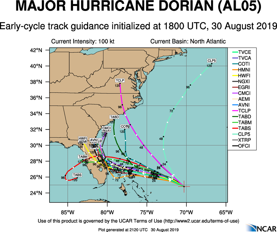
    I still think it's increasingly likely that this may not actually make landfall at all and could stay offshore, at least until it moves well north. The more it slows down the more chance an upper trough over the US has to dig down and pull it away northwards. The models are all going that way too, and by this time tomorrow these charts could look very different.

    aal05_2019083018_track_early.png


  • Registered Users Posts: 39,415 ✭✭✭✭Itssoeasy


    Okay it's a Cat4 now and it's 8:35pm florida time on a friday and the hurricane isn't meant to make landfall until monday night florida time. My question to the great and good on this forum, what will stop this from being a Cat 5 at landfall ?


  • Registered Users Posts: 4,813 ✭✭✭deisedude


    In Orlando on a family holiday until Thursday. Bricking it is putting it mildly. Contacted Tour America and they basically told us either wait it out or pay up to Aer Lingus to change flights. Orlando International Airport is closed from 2am Monday morning now


  • Advertisement
  • Registered Users Posts: 23,434 ✭✭✭✭Kermit.de.frog


    Mandatory evacuations now in some coastal counties of Florida. Not even hurricane warnings yet.


  • Registered Users Posts: 9,233 ✭✭✭sdanseo


    Itssoeasy wrote: »
    Okay it's a Cat4 now and it's 8:35pm florida time on a friday and the hurricane isn't meant to make landfall until monday night florida time. My question to the great and good on this forum, what will stop this from being a Cat 5 at landfall ?

    Low ocean temperatures and vertical windshear are the two things that will kill a tropical cyclone dead the fastest.

    The former means no fuel, and the latter quite literally pulls it apart.

    At the moment, ocean temperatures are high, and there is little windshear.

    https://www.weatheronline.co.uk/cgi-bin/expertcharts?LANG=en&MENU=0000000000&CONT=namk&MODELL=sst&MODELLTYP=3&BASE=-&VAR=1&HH=0&ARCHIV=0&PANEL=0&ZOOM=0&PERIOD=


  • Registered Users Posts: 23,434 ✭✭✭✭Kermit.de.frog


    I still think it's increasingly likely that this may not actually make landfall at all and could stay offshore, at least until it moves well north. The more it slows down the more chance an upper trough over the US has to dig down and pull it away northwards. The models are all going that way too, and by this time tomorrow these charts could look very different.

    aal05_2019083018_track_early.png

    The eye staying just offshore (as most models currently indicate) is worst possible scenario.

    Well off shore or straight onland for the eye is best scenario.


  • Registered Users Posts: 8,219 ✭✭✭Gaoth Laidir


    The eye staying just offshore (as most models currently indicate) is worst possible scenario.

    Well off shore or straight onland for the eye is best scenario.

    Just offshore would be bad, but if the current trend continues it could be well offshore. This is still all to play for, with even a southerly dive not out of the question either.


  • Registered Users Posts: 9,233 ✭✭✭sdanseo


    deisedude wrote: »
    In Orlando on a family holiday until Thursday. Bricking it is putting it mildly. Contacted Tour America and they basically told us either wait it out or pay up to Aer Lingus to change flights. Orlando International Airport is closed from 2am Monday morning now

    It's all about the preparation.

    Florida is exceptionally well prepared for Hurricanes. Follow the local authorities' advice.

    Compare Katrina, which hit Louisiana and caused untold devastation, to Michael last year which had a comparatively small human effect (everything being relative.. it still killed 31 people).


  • Advertisement
  • Registered Users Posts: 23,434 ✭✭✭✭Kermit.de.frog


    Just offshore would be bad, but if the current trend continues it could be well offshore. This is still all to play for, with even a southerly dive not out of the question either.

    Agree. Can't call anything yet.

    I also disagree somewhat with the upgrade to CAT 4 now. They state winds are "near" 130 mph. They either are or they aren't over 130 mph.

    We have seen liberties like this being taken before and I don't agree with it. That said, most recent recon does show 131 mph SL (but that is not what the NHC update was based on).

    Still they should be accurate but that's probably nit picking these days.


  • Registered Users Posts: 23,434 ✭✭✭✭Kermit.de.frog


    Latest pass

    recon_NOAA2-2105A-DORIAN_timeseries.png

    Definitely in CAT 4 territory now and continuing to strengthen.


  • Moderators, Recreation & Hobbies Moderators Posts: 11,056 Mod ✭✭✭✭igCorcaigh


    It's the rain will be the issue though, not the winds, or the landfall.


  • Registered Users Posts: 5,862 ✭✭✭RobAMerc


    In South beach Miami - 3 streets back from the Atlantic sea front. Hard to believe anything could be in the offing bar what we are hearing on the telly.

    Due to fly out Sunday night 10pm, ****ting it a little, my hotel doesnt seem terribly well prepared !

    Latest projections suggest it might be going about 100 miles north of us, heres hoping we are ling gone by the time this is near us !


  • Registered Users Posts: 23,434 ✭✭✭✭Kermit.de.frog


  • Registered Users Posts: 23,434 ✭✭✭✭Kermit.de.frog


    00z GFS keeping this off shore of Florida by a good 150 miles.

    Not so good for the Carolinas and Virgina.


  • Registered Users Posts: 8,219 ✭✭✭Gaoth Laidir


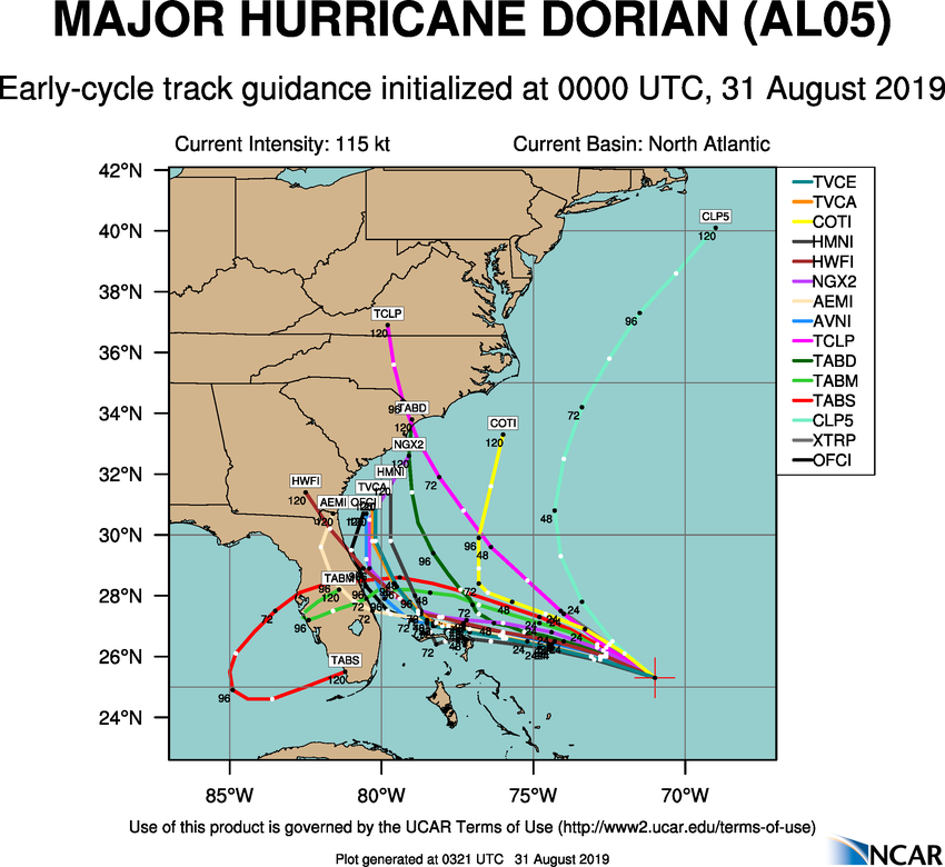
    The overall offshore trend continues, so the focus should be shifting away from the US and more on the Bahamas, which will be most effected by this. If it does affect the Carolinas its will most likely be in a much reduced state, with increased shear and drier air taking their toll.

    aal05_2019083100_track_early.png

    In the meantime, we should start to see some eyewall replacement cycles affect the overall intensity, so with a bit of luck that plus the Bahamas islands will limit the effects there. Those max winds quoted really are still only in a very tiny area.


  • Registered Users Posts: 8,219 ✭✭✭Gaoth Laidir


    The latest official track

    489537.jpg


  • Registered Users Posts: 8,219 ✭✭✭Gaoth Laidir


    With ocean heat content

    489538.jpg


  • Registered Users Posts: 8,230 ✭✭✭Merkin


    When is this due to reach land?


  • Advertisement
  • Registered Users Posts: 18,097 ✭✭✭✭JCX BXC


    Merkin wrote: »
    When is this due to reach land?

    Read through the thread, looking like late Monday


  • Registered Users Posts: 8,219 ✭✭✭Gaoth Laidir


    So it looks like Florida will dodge the bullet. With this new track the worst winds would be east or northeast of the centre and well offshore so it's more rain and sea effects that it would have to deal with. By landfall in SC it would be in a weakened state. But poor Bahamas...

    489544.png

    2019AL05_OHCNFCST_201908310600.GIF
    Hurricane Dorian Discussion Number 28
    NWS National Hurricane Center Miami FL
    AL052019 500 AM EDT Sat Aug 31 2019

    Dorian continues to look impressive in satellite imagery this morning, with a fairly symmetric area of cold cloud tops surrounding a 10-15 n mi wide eye. There have been no new aircraft data from the storm since the last advisory. However, the satellite appearance has changed little since the aircraft were last in the storm, and the various subjective and objective satellite intensity estimates have changed little over the past several hours. Based on this, the initial intensity remains 120 kt.

    The initial motion is now 290/10. A low- to mid-level subtropical ridge to the north of the hurricane should steer it west- northwestward to westward for the next 48 h or so, with the forward speed becoming very slow as the center passes near or over the Abacos and Grand Bahama. The track guidance for this part of the track is tightly clustered, and the new forecast track is near the ECMWF, UKMET, and HCCA corrected consensus models. The track forecast becomes much more problematic after 48 h. The global models the NHC normally uses, along with the regional HWRF and HMON models, have made another shift to the east to the point where none of them forecast Dorian to make landfall in Florida. However, the UKMET ensemble mean still brings the hurricane over the Florida peninsula, as do several GFS and ECMWF ensemble members. The new track forecast for 72-120 h will be moved eastward to stay east of the coast of Florida, and it lies between the old forecast and the various consensus models. Additional adjustments to the forecast track may be necessary later today if current model trends continue. It should be noted that the new forecast track does not preclude Dorian making landfall on the Florida coast, as large portions of the coast remain in the track cone of uncertainty. Also, significant impacts could occur even if the center stays offshore.

    Dorian should remain in a generally favorable environment for the next 3-4 days, and the intensity guidance indicates it will remain a powerful hurricane during this time. The new intensity forecast calls for a little more strengthening today, then it shows a slow weakening that follows the trend of the intensity guidance. During this time, the biggest intensity changes may come from hard-to- forecast eyewall replacement cycles. Late in the forecast period, increased vertical shear and proximity to land is expected to cause some weakening.


  • Moderators, Science, Health & Environment Moderators Posts: 11,803 Mod ✭✭✭✭Meteorite58


    Certainly looks like it is on the route up along the Eastern Seaboard. Added interest for Ireland for the latter stages of it's life span to see what the remnants have in store for us if any if they reach these latitudes in about 10 to 12 days. One thing for sure is that it will play havoc with the models with probable big swings from run to run , very much a time to watch for trends over the coming days. Models in fair agreement of its route as far as Newfoundland anyway at this stage. Could easily just head up towards Greenland / Iceland, jet will be important and if it merges with other areas of LP etc etc


    sEXAfxz.gif

    DPUtmgs.gif

    snHiCUp.png


  • Registered Users Posts: 2,815 ✭✭✭sparrowcar


    Any idea what time landfall on the Bahamas will be and any decent webcam or live streams to watch?

    Edit: Just seen cherryghosts post on first page.


  • Registered Users Posts: 7,114 ✭✭✭pad199207


    A Cat 5 or strong Cat 4 up along the coast of Florida would still cause huge damage even if it doesn’t make landfall.

    Latest models still startling.


  • Registered Users Posts: 19 orkyorky


    Heading straight for ireland coming fast across the atlantic, forget about america ;)


  • Registered Users Posts: 7,114 ✭✭✭pad199207


    Sustained winds are at 145mph now.


  • Registered Users Posts: 9,233 ✭✭✭sdanseo


    Another one potentially spinning up off Africa also.


  • Registered Users Posts: 7,114 ✭✭✭pad199207


    Unconfirmed yet by NOAA that latest recorded surface winds are near 160mph!

    Confirmed as 150mph now so still just under Cat 5.
    West side of the storm doesn’t look as organized perhaps due to some mid level shear. Still obviously not having any effect on the storms intensification

    Someone’s prayers were answered. What a dodge.
    5-FC82-AF4-E360-4649-8-D45-A5-DEFA9-EDF25.jpg


  • Advertisement
  • Registered Users Posts: 8,219 ✭✭✭Gaoth Laidir


    pad199207 wrote: »
    Unconfirmed yet by NOAA that latest recorded surface winds are near 160mph!

    Confirmed as 150mph now so still just under Cat 5.
    West side of the storm doesn’t look as organized perhaps due to some mid level shear. Still obviously not having any effect on the storms intensification

    That was an isolated 138-kt SFMR reading, followed by one of 127 kts.

    142730 2603N 07319W 7477 02145 9555 +165 +161 096112 131 138 004 00

    recon_NOAA2-2205A-DORIAN_timeseries.png

    It's good to see that track now.moving further offshore and even more away from the northern Bahamas. This could turn into a fishstorm after all that!


Advertisement