Advertisement
If you have a new account but are having problems posting or verifying your account, please email us on hello@boards.ie for help. Thanks :)
Hello all! Please ensure that you are posting a new thread or question in the appropriate forum. The Feedback forum is overwhelmed with questions that are having to be moved elsewhere. If you need help to verify your account contact hello@boards.ie
Hi all,
Vanilla are planning an update to the site on April 24th (next Wednesday). It is a major PHP8 update which is expected to boost performance across the site. The site will be down from 7pm and it is expected to take about an hour to complete. We appreciate your patience during the update.
Thanks all.

2020 Hurricane Season (Atlantic & East Pacific)

15791011

Comments

  • Registered Users Posts: 8,219 ✭✭✭Gaoth Laidir


    The eye is now moving off to the northwest of the island, with strong southwesterly winds from the southern eyewall getting in. Weather is Blowing Spray and a nearby shower.
    METAR TXKF 141055Z 24048G62KT 3200 BPLY VCSH OVC010TCU 26/25 Q0977 RMK TCU E=


  • Registered Users Posts: 7,114 ✭✭✭pad199207


    We now have Vicky

    43986459-2524-42-E5-BD62-31-A723-A75-C1-A.jpg


  • Registered Users Posts: 8,219 ✭✭✭Gaoth Laidir


    Vicky has made a cameo appearance but will be short-lived, shear weakening it again over the next day or two.

    526325.png


  • Registered Users Posts: 17,797 ✭✭✭✭hatrickpatrick


    Sally is yet another Rapidly Intensifying Gulf storm. At the point it wouldn't surprise me in the least to see a Category 3 landfall, as has been the case so often in recent years she hit the warm Eddy in the GoM and has been bombing out ever since.

    It's a very worrying trend to see these RI events occurring so close to landfall. It undermines the ability of weather forecasters and government officials alike to make predictions as to how large scale an evacuation may be needed, etc. The tightrope of "overstate it too often and people become immune to the threat and ignore future warnings, understate it and it's too late to evacuate" is become a lot more difficult in light of this.

    Jeff Masters did a post on it a few weeks ago:

    https://yaleclimateconnections.org/2020/08/climate-change-is-causing-more-rapid-intensification-of-atlantic-hurricanes/

    2020 will surely be remembered as the year of last-minute monsters. I don't know enough about modelling science to say whether weather models could be theoretically designed to take this new era of rapid intensification into account when predicting landfall strength, but at the moment it seems that all of the models under-perform in this regard, with the exception of the ICON and HWRF models which, unfortunately, have the opposite issue in that they tend to falsely predict RI events too often such that when one is genuinely about to occur, too many people say "sure, but the HWRF / ICON models are always doing this, it's nothing to be concerned about really".


  • Registered Users Posts: 8,219 ✭✭✭Gaoth Laidir


    Sally is yet another Rapidly Intensifying Gulf storm. At the point it wouldn't surprise me in the least to see a Category 3 landfall, as has been the case so often in recent years she hit the warm Eddy in the GoM and has been bombing out ever since.

    It's a very worrying trend to see these RI events occurring so close to landfall. It undermines the ability of weather forecasters and government officials alike to make predictions as to how large scale an evacuation may be needed, etc. The tightrope of "overstate it too often and people become immune to the threat and ignore future warnings, understate it and it's too late to evacuate" is become a lot more difficult in light of this.

    Jeff Masters did a post on it a few weeks ago:

    https://yaleclimateconnections.org/2020/08/climate-change-is-causing-more-rapid-intensification-of-atlantic-hurricanes/

    2020 will surely be remembered as the year of last-minute monsters. I don't know enough about modelling science to say whether weather models could be theoretically designed to take this new era of rapid intensification into account when predicting landfall strength, but at the moment it seems that all of the models under-perform in this regard, with the exception of the ICON and HWRF models which, unfortunately, have the opposite issue in that they tend to falsely predict RI events too often such that when one is genuinely about to occur, too many people say "sure, but the HWRF / ICON models are always doing this, it's nothing to be concerned about really".

    Sally has actually been over a cold eddy, not a warm one.

    526349.gif

    The increase in aircraft recon missions, sometimes with two or three aircraft in and around a storm at the same time, most definitely has something to do with the increase in detection of RI events. Several storms have been upped in intensity solely due to last-minute recon data. The record is not homogeneous and therefore the type of language of certainty by Masters in his blog is a bit unwarranted.


  • Advertisement
  • Banned (with Prison Access) Posts: 1,075 ✭✭✭smellyoldboot


    Will we see any action from these yokes that are knocking about the mid Atlantic?


  • Registered Users Posts: 8,219 ✭✭✭Gaoth Laidir


    Will we see any action from these yokes that are knocking about the mid Atlantic?

    Very unlikely.


  • Closed Accounts Posts: 127 ✭✭New Era


    Will we see any action from these yokes that are knocking about the mid Atlantic?

    I asked that same question in the current weather - Autumn 2020 thread. I just checked the normally reliable ecmwf charts for the next seven days. Paulette is hovering around the North Atlantic but is expected to weaken and dissipate by the end of the week.

    I also noticed of a very large and deepening area potentially horrendous low pressure system, that at the moment could impact Greenland and has a chance to impact ourselves early next week, but hopefully the high pressure over the British Isles will become some kind of blocking high for next weeks weather.

    At this time I don't look no further than seven days ahead in the weather forecasts, due to this volatile hurricane situation in the North and mid Atlantic.


  • Registered Users Posts: 12,955 ✭✭✭✭bnt


    Five named systems in the Atlantic: this has only happened once before since we developed the capability to monitor the whole ocean, and that was back in September 1971. There were six storms then: Edith, Fern, Ginger, Heidi and Irene, plus one officially named "Unnamed".

    From out there on the moon, international politics look so petty. You want to grab a politician by the scruff of the neck and drag him a quarter of a million miles out and say, ‘Look at that, you son of a bitch’.

    — Edgar Mitchell, Apollo 14 Astronaut


  • Registered Users Posts: 2,656 ✭✭✭Darwin


    Teddy is set to develop into a major hurricane by Friday with Bermuda a possible landfall if it continues along its current vector. Really hope our high pressure hangs on, the jetstream looks to be keeping away from us for another 10 days at least.


  • Advertisement
  • Registered Users Posts: 8,219 ✭✭✭Gaoth Laidir


    NOAA aircraft that measured SFMR winds up to 78 knots in the northwest eyewall of Sally earlier is about to come in around for another pass into that area now. Interesting to see what it measures. There were some suspect SFMR readings immediately after that 78 knots one, so we'll see if we get anything that high or higher now.

    recon_NOAA3-0719A-SALLY.png

    recon_NOAA3-0719A-SALLY_timeseries.png


  • Registered Users Posts: 8,219 ✭✭✭Gaoth Laidir


    That KVOA station is a Petronius oil platform and is the closest to the centre now. It's reporting northeast winds of 56 gust 69 knots at an anemometer height of 16 metres. The 56-knot 10-minute mean wind would equate to around 64 knots 1-minute in NHC speak. Pressure 966.4 hPa.

    https://www.wrh.noaa.gov/map/?&zoom=7&scroll_zoom=true&center=28.7000,-87.2000&basemap=OpenStreetMap&boundaries=true,false,false&hazard=true&hazard_type=hi-all&hazard_opacity=60&obs=true&obs_type=weather&elements=temp,dew,wind,rh,gust,slp&obs_popup=true&obs_density=1


  • Registered Users Posts: 8,219 ✭✭✭Gaoth Laidir


    Aircraft measured max SFMR wind of 78 knots in the NW eyewall now, but flight level wind of only 69 knots in the same area. Unusual to have a FL wind lower than the SFMR. Minimum pressure 988.6 hPa.

    That oil platform is now up to 65 gusting 80 knots.


  • Moderators, Society & Culture Moderators Posts: 1,706 Mod ✭✭✭✭star gazer


    Slow moving Sally is a serious threat between storm surge and rainfall totals as well as the wind speed.
    STORM SURGE: The combination of a dangerous storm surge and the
    tide will cause normally dry areas near the coast to be flooded by
    rising waters moving inland from the shoreline. The water could
    reach the following heights above ground somewhere in the indicated
    areas if the peak surge occurs at the time of high tide...

    Mouth of the Mississippi River to Ocean Springs, MS including Lake
    Borgne...7-11 ft
    Ocean Springs, MS to Dauphin Island, AL...6-9 ft
    Mobile Bay...5-8 ft
    Lake Pontchartrain and Lake Maurepas...3-5 ft
    Dauphin Island, AL to AL/FL Border...4-6 ft
    Port Fourchon, LA to Mouth of the Mississippi River...2-4 ft
    AL/FL Border to Chassahowitzka, FL including Pensacola Bay,
    Choctawhatchee Bay, and Saint Andrew Bay...1-3 ft
    Burns Point, LA to Port Fourchon, LA...1-2 ft

    Overtopping of local levees outside of the Hurricane and Storm
    Damage Risk Reduction System is possible where local inundation
    values may be higher than those shown above.

    RAINFALL: Sally is expected to be a slow moving system as it
    approaches land, producing 8 to 16 inches of rainfall with isolated
    amounts of 24 inches over portions of the central Gulf Coast from
    the western Florida Panhandle to far southeast Louisiana through the
    middle of the week. Life-threatening flash flooding is likely. In
    addition, this rainfall will likely lead to widespread minor to
    isolated major flooding on area rivers.
    About 300mm = 1 foot/12 inches NHC


  • Registered Users Posts: 7,114 ✭✭✭pad199207


    Sally now a Cat 2


  • Registered Users Posts: 8,219 ✭✭✭Gaoth Laidir


    That oil platform KVOA actually has an anemometer height of 160 metres above the sea surface, which is why reported a peak 8-minute wind of 87 knots (converting to a 1-minute mean of around 96 knots) and a gust of 102 knots as the northwestern eyewall passed through. At the standard 10 metres height the 96 knots would reduce to around 77 knots.

    Buoy 42040, 30 miles to the west, has reported peak 8-minute of 39 knots (44 knots 1-minute).

    526375.png


  • Registered Users Posts: 8,219 ✭✭✭Gaoth Laidir


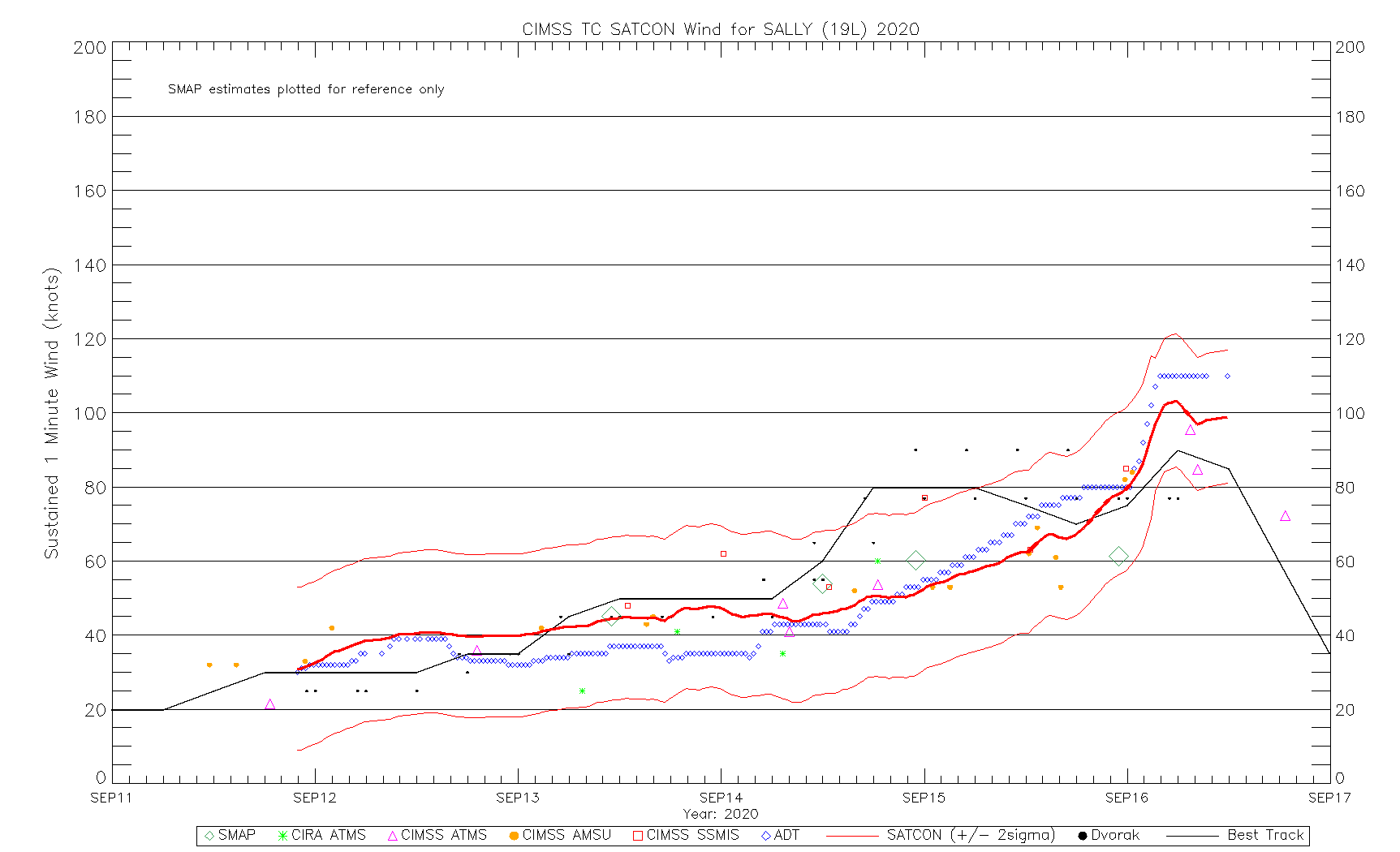
    The latest satcon intensity estimate shows what I was saying earlier about the difference frequent aircraft recon data have on official intensity fixes. The classical satellite estimates are all shown in various colours while the official NHC best track estimate is in grey. The NHC have gone way above all of the satcon estimates today as recon data have come in. Without these the official intensity would have been more like somewhere around 60 knots. This has happened on several other occasions too, which calls into question the validity of comparing rapid intensity trends of recent years, when recon aircraft have become like bees around a hive. How many historical storms have had similar real intensities and not had them measured by aircraft?

    202019L_wind_ssmis.gif


  • Registered Users Posts: 8,219 ✭✭✭Gaoth Laidir


    Sally has weakened overnight and aircraft data haven't found any surface winds above 58 knots, nor have there been surface buoy or platform winds that high, yet the NHC continue to give it an intensity of 75 knots. I sometimes struggle to understand their logic.
    Hurricane Sally Discussion Number 16...Corrected
    NWS National Hurricane Center Miami FL AL192020
    400 AM CDT Tue Sep 15 2020

    Corrected Key Messages 2 and 3

    There has been little change overall in Sally's convective
    structure in both satellite and Doppler radar data. An eye has tried
    to close off several times this morning, but after less than 30
    minutes the southern eyewall has eroded. Until just recently, the
    central pressure had been steady for the past several hours at 986
    mb. However, the most recent Air Force Reserve reconnaissance pass
    through Sally's center reported a dropsonde pressure of 984 mb and
    13 kt winds, which equals a pressure of 983 mb. Maximum 700-mb
    flight-level winds observed have only been 63 kt and peak SFMR
    winds have been 58 kt. Also, reports from nearby oil rigs have
    dropped off significantly since yesterday are are now in the 40-50
    kt range. Based on these data, the initial intensity has been
    lowered to 75 kt.

    The initial motion estimate to 300/02 kt. After a brief jog due
    west, it appears that Sally has resumed a slow drift toward the
    west-northwest. Sally is embedded within weak steering flow based
    on 0000Z upper-air data indicating 500-mb heights of 5900 meters
    and slightly higher surrounding the cyclone from Florida northward
    into the Tennessee Valley and then westward into the central and
    southern Plains. This weak steering pattern is expected to persist
    for the next few days, with a weak mid-level trough forecast to
    move into the Missouri and Tennessee Valleys by Wednesday and
    Thursday, which will gradually lift Sally northward and then
    northeastward. Sally is forecast to merge with a frontal system by
    day 4 or 5. The new NHC forecast track is similar to the previous
    advisory and lies down the middle of the rather divergent model
    guidance envelope.

    Sally is now expected to remain in a moderate to high mid-to
    upper-level wind shear environment. Ina addition, some modest
    upwelling is likely occurring in the inner-core region based a SST
    decrease of nearly 2 deg F during the past 24 hours based on data
    from buoy 42012. After the Sally makes landfall, rapid weakening is
    forecast and Sally should become post-tropical in 3 days or less.

    Users are reminded to not focus on the exact forecast track or the
    specific timing and location of landfall. Hurricane-force winds,
    dangerous storm surge, and flooding rainfall will affect a large
    portion of the north-central Gulf Coast during the next few days.

    KEY MESSAGES:

    1. It is still too early to determine where Sally's center will move
    onshore given the uncertainty in the timing and location of Sally's
    northward turn near the central Gulf Coast. Users should not focus
    on the details of the official forecast track, since NHC's average
    forecast error at 36 hours is around 60 miles, and dangerous storm
    surge, rainfall, and wind hazards will extend well away from the
    center.

    2. An extremely dangerous and life-threatening storm surge is
    expected for areas outside the southeastern Louisiana Hurricane and
    Storm Damage Risk Reduction System from the Mouth of the Mississippi
    River to the Okaloosa/Walton County Line in the Florida Panhandle,
    where a Storm Surge Warning is in effect. Residents in these areas
    should follow any advice given by local officials.

    3. Hurricane conditions are expected today within the Hurricane
    Warning area along the Mississippi and Alabama coastlines and the
    western Florida Panhandle. Tropical storm conditions are already
    occurring in some of these areas.

    4. Historic flooding is possible with extreme life-threatening flash
    flooding likely through Wednesday along and just inland of the
    central Gulf Coast from the western Florida Panhandle to far
    southeastern Mississippi. Widespread moderate to major flooding on
    area rivers is forecast along and just inland of the central Gulf
    Coast. Significant flash and urban flooding, as well as widespread
    minor to moderate river flooding is likely across inland portions of
    Mississippi, Alabama, northern Georgia, and the western Carolinas
    through the week.


    FORECAST POSITIONS AND MAX WINDS

    INIT 15/0900Z 28.9N 88.1W 75 KT 85 MPH
    12H 15/1800Z 29.2N 88.4W 75 KT 85 MPH
    24H 16/0600Z 29.9N 88.5W 75 KT 85 MPH
    36H 16/1800Z 30.6N 88.3W 60 KT 70 MPH...INLAND
    48H 17/0600Z 31.4N 87.5W 35 KT 40 MPH...INLAND
    60H 17/1800Z 32.2N 86.2W 25 KT 30 MPH...INLAND
    72H 18/0600Z 32.8N 84.6W 20 KT 25 MPH...POST-TROP/REMNT LOW
    96H 19/0600Z 33.2N 81.3W 20 KT 25 MPH...POST-TROP/EXTRATROP
    120H 20/0600Z...DISSIPATED

    2020al19_airctcwa_202009150600_swhr.gif

    I like the subtle pun in the discussion on TS Teddy, which is forecast to become a Cat 3 later on.
    ....
    Teddy bears watching in the long range for
    category 4 strength, but regardless of the details, all of the
    guidance show it becoming a classical large and powerful September
    hurricane.
    ...


  • Registered Users Posts: 14,318 ✭✭✭✭M.T. Cranium


    Teddy bears down on Bermuda would make a good headline (earlier on it was supposed to miss by a small margin to the east, the 00z GFS takes it right over top of Bermuda).

    Looked earlier like neither Paulette nor Sally would have any time as a major so the count remains 20/7/1 until Teddy boosts it to 20/8/1 or 20/8/2 perhaps tonight or tomorrow. (added later _ Sally moving at a snail's pace towards landfall has intensified more than predicted and is a borderline cat-3 storm now, advisory not out yet but 110 mph winds detected) ... Vicky does not seem to have much of a future either (although she stubbornly clings to 50 mph intensity).

    So really if the season were to be at 13/8/1 or 2 it would seem rather anemic, and there have been at least seven weak tropical storms, so ... it continues to underwhelm somewhat.

    Just as with 2005, it's female named storms that are the stronger of the two.


  • Registered Users Posts: 107 ✭✭savj2


    Check out the Medicane off the coast of Greece.

    https://earth.nullschool.net/#current/wind/surface/level/orthographic=-340.11,35.77,1002/loc=4.004,33.009

    Going to strengthen as well into a powerful tropical like storm and hit Greece.


  • Advertisement
  • Registered Users Posts: 8,219 ✭✭✭Gaoth Laidir


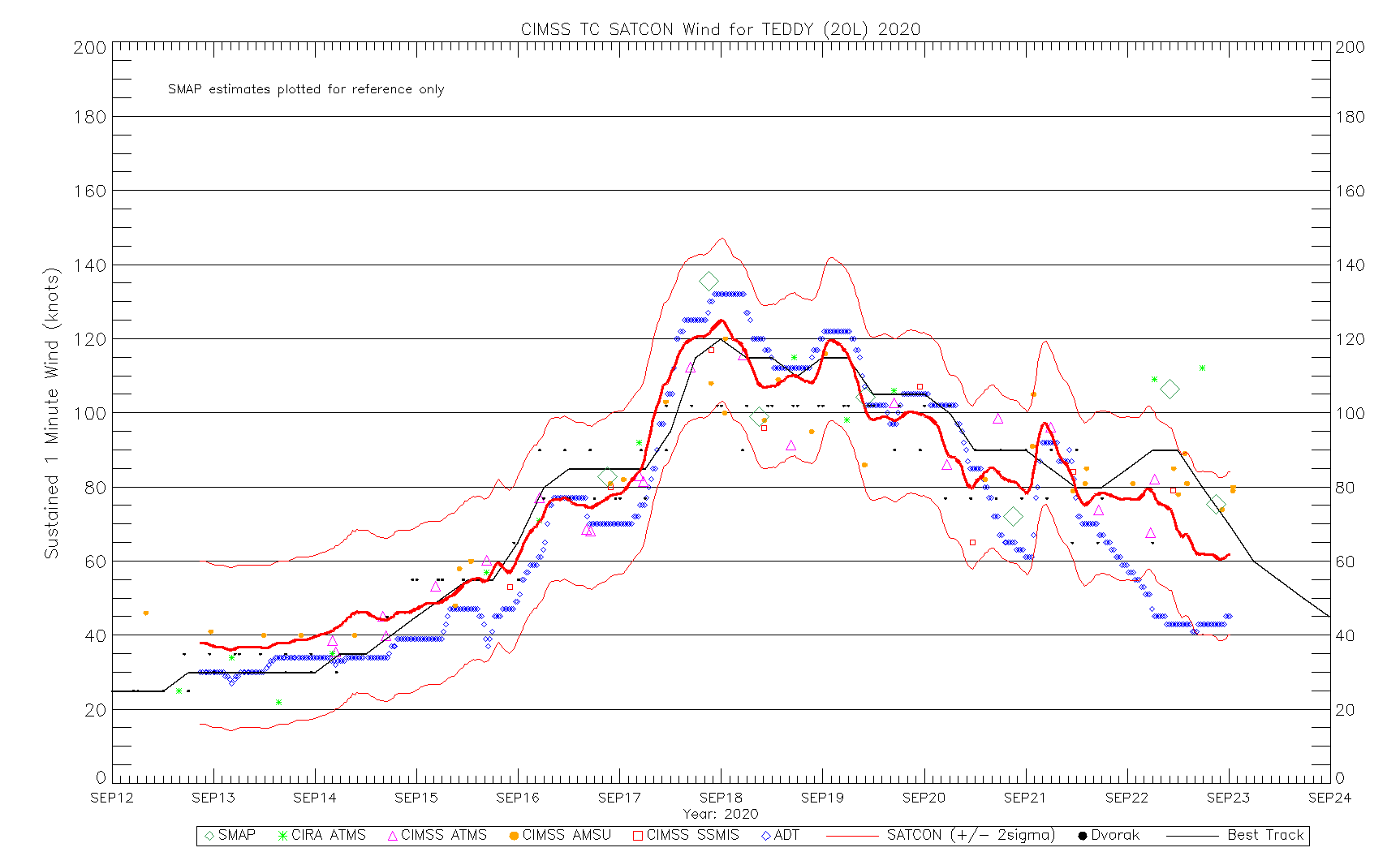
    Teddy intensified to 120 knots (Cat 4) this evening due to a combination of low shear and water temperatures of around 28.5 degrees, heat content around 55 kJ/cm². It is the second major hurricane of the season. It could strengthen slightly more overnight before levelling off and then slowly decreasing as mid levels dry out slightly and heat content reduces around the upwelled wake of Paulette. It could come close to Bermuda Sunday/Monday, but at that stage it's looking more like Cat 2/1.

    526641.png

    202020L_wind_ssmis.gif


  • Registered Users Posts: 8,219 ✭✭✭Gaoth Laidir


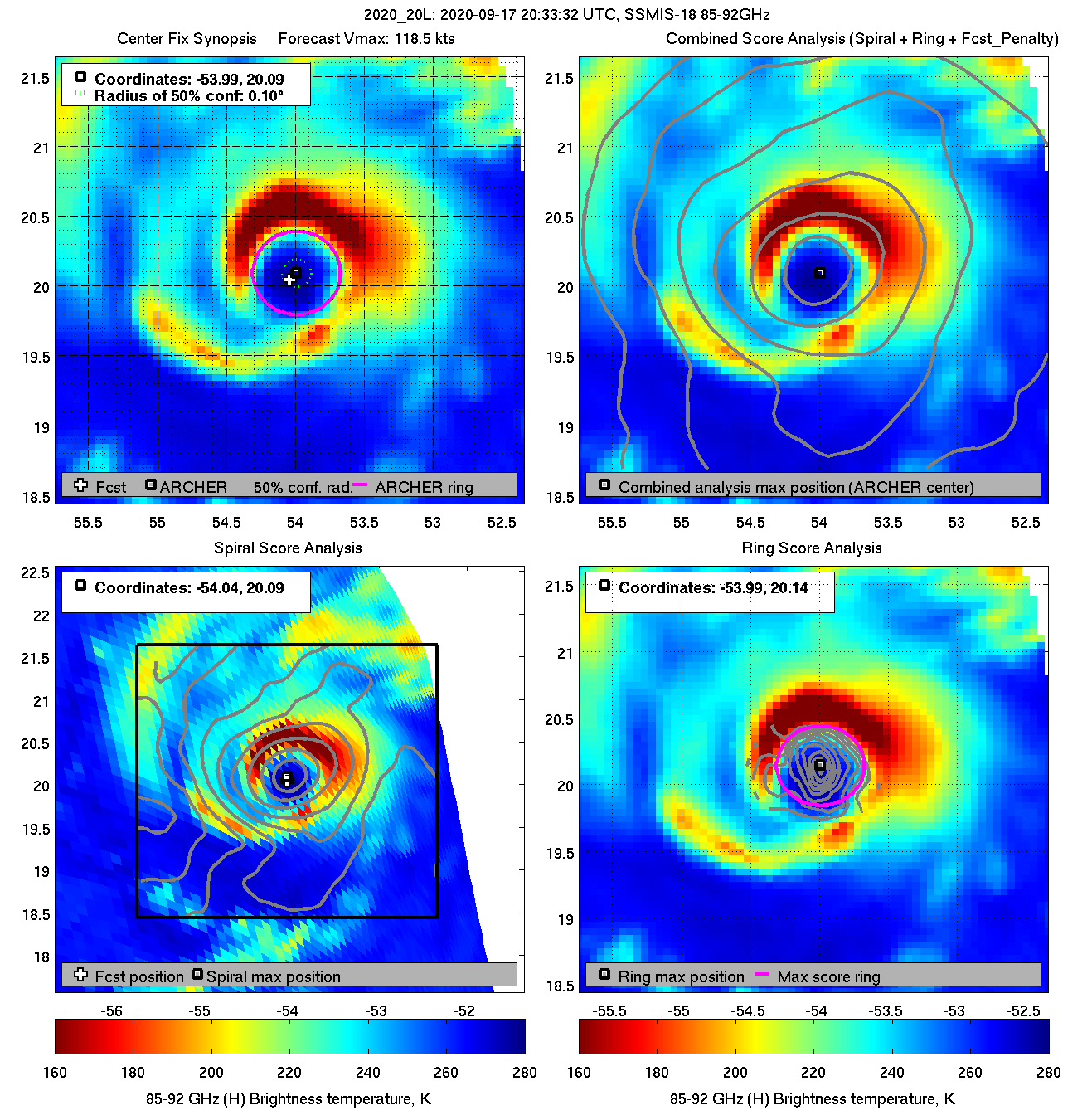
    A good eyewall has formed around most of the centre. Finally a proper Atlantic hurricane this season.

    diag20200917T203332_ssmis18_85.png


  • Registered Users Posts: 9,233 ✭✭✭sdanseo


    A good eyewall has formed around most of the centre. Finally a proper Atlantic hurricane this season.

    Laura wasn't a proper Hurricane when it destroyed a decent chunk of Louisiana? :eek: :pac:


  • Registered Users Posts: 8,219 ✭✭✭Gaoth Laidir


    sdanseo wrote: »
    Laura wasn't a proper Hurricane when it destroyed a decent chunk of Louisiana? :eek: :pac:

    I mean it's a proper major hurricane from the MDR that's slowly developed in the traditional way and will last for a decent amount of time. Laura was of course major too but it was a bit more messy on satellite most of the time.


  • Registered Users Posts: 8,219 ✭✭✭Gaoth Laidir


    Tropical Storm Wilfred has developed in the MDR and is by 3 weeks the earliest 21st-named Atlantic storm on record. Like many others, though, it will not amount to much, reaching only 40 knots over the next couple of days before dissipating in mid-Atlantic within 5 days.

    Tropical Depression 22 formed in the SW Gulf of Mexico overnight and may or may not get up to near hurricane strength near the Mexico or Texas coast in 3 days or so. Note this from the latest discussion on it.
    It should be noted that the Air Force Reserve Hurricane Hunter aircraft that was scheduled to investigate the depression had to turn back after getting hit by lightning.

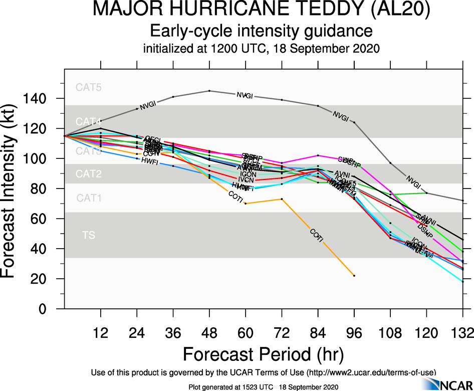
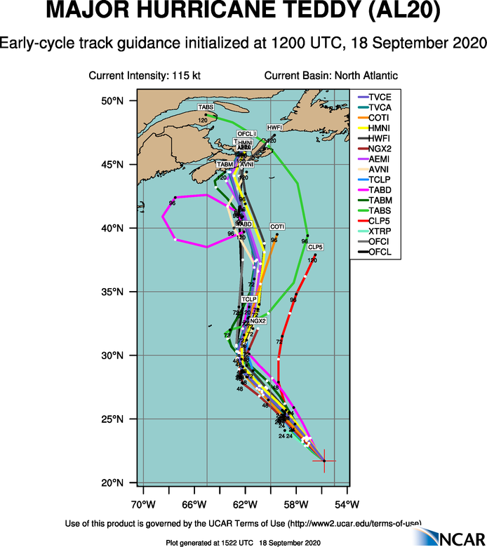
    Meanwhile, Teddy is going strong at 115 knots and should hold that for a little while longer before a gradual weakening phase occurs before hitting Nova Scotia as an extra-tropical storm.

    12Z SHIPS

    aal20_2020091812_intensity_early.png

    aal20_2020091812_track_early.png


  • Registered Users Posts: 14,318 ✭✭✭✭M.T. Cranium


    Now they have slapped the name Alpha on the low approaching Portugal. That seems a bit over the top, it's a low.

    Anyway, this means no Hurricane Alpha again in 2020 and probably Hurricane Beta again (the GOM thing about to get a name).

    I just think they are pulling out all the stops to get to Mu and Nu which should excite comedians as much as climatologists.


  • Registered Users Posts: 9,233 ✭✭✭sdanseo


    That seems a bit ridiculous alright. The very first advisory is for it to dissipate within a day or so.
    I get that it technically meets the criteria, but you'd have to think they regularly ignore lows like this so far NE.


  • Registered Users Posts: 8,219 ✭✭✭Gaoth Laidir


    It all helps beef up the stats, the same way they sometimes give intensities higher than any of the available data suggest. Alpha was just a normal extratropical low that's been moving southwards during the week and happened to develop convection, hence it's classified a sub-tropical low. No tropical origins whatsoever. Still, Ryan Maue will be on Twitter with more exaggerated statements on it. It's already made landfall in mid-Portugal.

    526757.png


  • Registered Users Posts: 8,219 ✭✭✭Gaoth Laidir


    UKMO FAX analysis at 18Z.

    ukmo_nat_fax_2020091818_000.png


  • Advertisement
  • Registered Users Posts: 8,219 ✭✭✭Gaoth Laidir


    Tropical Storm Beta has been named in the western Gulf overnight and it may reach hurricane status before making landfall somewhere along the southwestern Texas coast. It looks like it could skirt up along the coast for the next few days, but forecast confidence is very low and this map could completely change again.
    INIT 19/0900Z 26.0N 92.5W 50 KT 60 MPH
    12H 19/1800Z 26.6N 92.6W 55 KT 65 MPH
    24H 20/0600Z 26.9N 93.4W 60 KT 70 MPH
    36H 20/1800Z 27.1N 94.3W 65 KT 75 MPH
    48H 21/0600Z 27.4N 95.2W 70 KT 80 MPH
    60H 21/1800Z 27.7N 95.9W 70 KT 80 MPH
    72H 22/0600Z 28.1N 96.3W 65 KT 75 MPH
    96H 23/0600Z 28.7N 95.4W 60 KT 70 MPH
    120H 24/0600Z 29.7N 93.3W 50 KT 60 MPH

    526805.png


Advertisement