Advertisement
If you have a new account but are having problems posting or verifying your account, please email us on hello@boards.ie for help. Thanks :)
Hello all! Please ensure that you are posting a new thread or question in the appropriate forum. The Feedback forum is overwhelmed with questions that are having to be moved elsewhere. If you need help to verify your account contact hello@boards.ie
Hi all,
Vanilla are planning an update to the site on April 24th (next Wednesday). It is a major PHP8 update which is expected to boost performance across the site. The site will be down from 7pm and it is expected to take about an hour to complete. We appreciate your patience during the update.
Thanks all.

Tralee to Fenit Greenway

2456724

Comments

  • Registered Users Posts: 834 ✭✭✭kingdumb


    That's great news, when do expect clearance work to start on the Bracker o'Reagan to Fenit and Rock Street to the Train Station sections to begin ?
    PRESS RELEASE
    For immediate release

    Council to start clearance work on section of Tralee-Fenit Railway Line
    25/02/2012


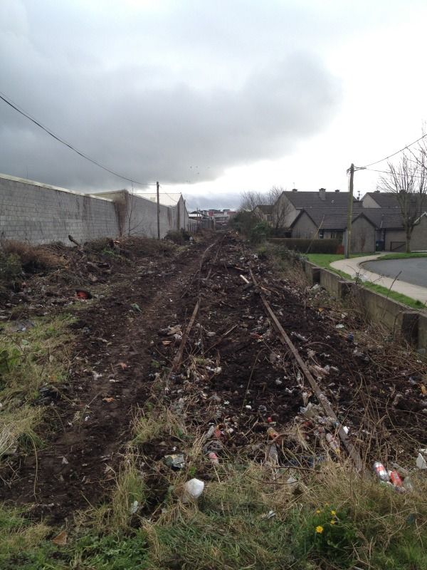
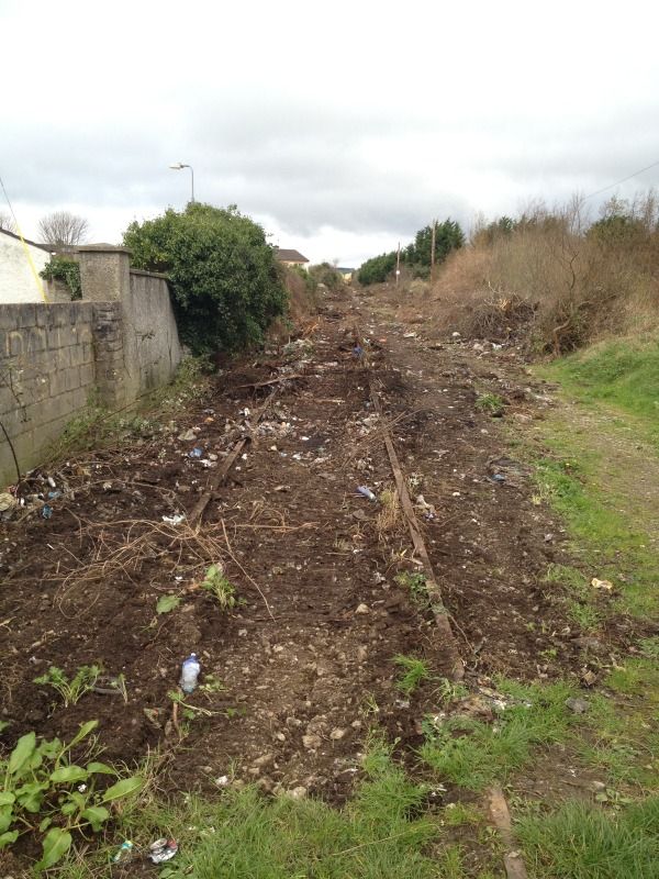
    Kerry County Council will be starting clearance works today, Friday, February 24th on a stretch of the Fenit Railway line from Rock Street to Bracker O'Regan Road, Mounthawk.

    The works will involve the cutting back of the trees and undergrowth, back to the railway boundary, along with the removal of rubbish and debris. The work, which is being carried out by Kerry County Council staff is expected to continue until next Friday.

    In some cases, the clearance works may see some residential properties along the route have their properties exposed. In these cases, Kerry County Council will be working with the owners to secure the property.

    "There will be some properties where the clearance works will expose their property," a Council spokesperson stated. "Where that happens, security fencing will be immediately erected to protect their property and we will be putting more permanent boundaries in place afterwards.

    "We will be speaking to those residents during the next few days and those who have queries are asked to contact Kerry County Council's Roads Department on 066 7183588 or email: roads@kerrycoco.ie

    The clearance works will allow the Council to prepare detailed drawings and costings for works along the route relating to the proposed Tralee-Fenit walkway.

    "We are currently finalising a number of issues and hope to be in a position to start the Part 8 Planning Process in relation to the Rock Street to Mounthawk section of the walkway in the next few weeks," the spokesperson said.


  • Registered Users Posts: 834 ✭✭✭kingdumb


    To you have a link/ref. to NTA's stance ?

    I am sure the NTA should be more concerned at IR/CIE's lack of care for state owned lands.

    Of course I would love to see trains running on the the line again but, that's not going to happen in the near future, so at least by having it as a greenway it will stop encroachments onto the land and keep the line intact !
    Very interesting but as I understand it the NTA have serious reservations about the walkway given that the Tralee/Fenit line is still part of the National rail network - it has never been closed.


  • Registered Users Posts: 203 ✭✭trail man


    CIE dont give a hoot about the line and would gladly wash their hands of it..
    as far as the nta are concerned i wouldnt loose too much about it..
    The hurdle to cross will be the landowners That will be the beechers brook of the fenit line greenway....
    Keep up the good work and anything is possible...
    SOUTHERN TRAIL OLD DOG...


  • Registered Users Posts: 815 ✭✭✭Quaderno


    trail man wrote: »
    The hurdle to cross will be the landowners That will be the beechers brook of the fenit line greenway...

    I thought the ownership issue had already been sorted out between CIE and the town council?
    Anyway, I just went down to have a quick look, and at least on the rock street side I failed to spot any activity apart from the pictured sign. I didn't check from Bracker O'Reagan road, though. Can't wait to see it happen :)

    194080.jpg

    194081.jpg


  • Site Banned Posts: 60 ✭✭Kerry County Council


    Work started this morning on the Mounthawk side


  • Advertisement
  • Closed Accounts Posts: 320 ✭✭stevielenihan


    will there be further photos taken as more work progresses?


  • Closed Accounts Posts: 320 ✭✭stevielenihan


    when will they start building the walkway?


  • Registered Users Posts: 203 ✭✭trail man


    Hey stevie..
    They will start next sunday morning at 5.45 am... come along and give us a hand..:cool:....


  • Registered Users Posts: 815 ✭✭✭Quaderno


    will there be further photos taken as more work progresses?

    Yes, I am sure there are enough people here (myself included) who will keep an eye on the developments and take pictures every now and then. The County Council will want to have a good documentation of the progress as well, so there will be more pics very soon here or there.
    As for the start of the actual building works: I am quite sure there has to be a proper planning process first and then the work and supply of materials will most likely have to go on tender. So I would think that we are still (at least) several months away from anything that goes beyond clearing out overgrowth and securing adjacent properties. But the first steps are done.


  • Closed Accounts Posts: 320 ✭✭stevielenihan


    trail man wrote: »
    Hey stevie..
    They will start next sunday morning at 5.45 am... come along and give us a hand..:cool:....


    Hey Trailman i will give ye a hand. Ok but at least the clearing work is underway


  • Advertisement
  • Closed Accounts Posts: 320 ✭✭stevielenihan


    when will they be clearing the rest of the railway line back to fenit?


  • Registered Users Posts: 815 ✭✭✭Quaderno


    when will they be clearing the rest of the railway line back to fenit?

    I think they cleared a large part of the track between the town and Fenit in 2010 - until they were stopped by some residents. But a lot of the work has already been done:
    194255.jpg

    I took another couple of pictures just an hour ago and the clearing in Mounthawk seems to advance quite well:
    194256.jpg
    194257.jpg


  • Closed Accounts Posts: 320 ✭✭stevielenihan


    will the tracks have to be lifted for the walk to be build?


  • Registered Users Posts: 11,318 ✭✭✭✭carchaeologist


    Quaderno wrote: »
    194080.jpg

    194081.jpg
    Here is the updated pictures of the above as of this morning..

    IMG_2967.jpg
    IMG_2966.jpg


  • Registered Users Posts: 4,349 ✭✭✭Jimmy Garlic


    Second option! Genuinely surprised they havent been nicked, or that the rail crowd didnt take them.
    Anyone know the gauge?

    Nicking them would be way too much work for those who have a habit of nicking scrap metal.


  • Registered Users Posts: 142 ✭✭555guy


    interesting to see how intact the rails are .. you'd never know it from the before pics. Also interesting to see how the clearing so far has opened up onto the housing nearby ...


  • Registered Users Posts: 645 ✭✭✭amadain


    when will they be clearing the rest of the railway line back to fenit?

    The stretch from the Spa back down to Mounthawk is next few weeks.

    Won't it be great to walk to Spa this summer !


  • Closed Accounts Posts: 13,549 ✭✭✭✭Judgement Day


    It would have been even better to take the train to Spa. There were seaside trains to Fenit from Castleisland and Tralee as late as the 1970s - not bad for a line that lost its regular passenger service as far back as 1934!


  • Registered Users Posts: 203 ✭✭trail man


    This is a fantastic development and has gigantic potential as a local/tourist amenity...no reason why in the long term it that it couldnt be linked with the rest of the north kerry line and eventually you could cycle/walk from fenit to limerick city via the great southern trail. ...ALL THE REST OF EUROPE HAVE DONE THIS WITH OLD RAILWAY LINES AND ARE MAKING A MINT FROM ECO TOURISM...


  • Registered Users Posts: 4,349 ✭✭✭Jimmy Garlic


    trail man wrote: »
    This is a fantastic development and has gigantic potential as a local/tourist amenity...no reason why in the long term it that it couldnt be linked with the rest of the north kerry line and eventually you could cycle/walk from fenit to limerick city via the great southern trail. ...ALL THE REST OF EUROPE HAVE DONE THIS WITH OLD RAILWAY LINES AND ARE MAKING A MINT FROM ECO TOURISM...

    Where does the great southern trail extent to now? Abbeyfeale?.


  • Advertisement
  • Registered Users Posts: 815 ✭✭✭Quaderno


    kingdumb wrote: »
    That's great news, when do expect clearance work to start on the Bracker o'Reagan to Fenit and Rock Street to the Train Station sections to begin ?

    I just had a look at that latter part of the track and I now have to say that I do no longer think this will ever happen. The short path between Edward Street and the Big River (behind An Sean Mhuíleann) shouldn't cause any problems, but at least at the moment it doesn't seem to be a realistic possibility to follow the old line from there any further towards the Rock Street crossing.
    I see two reasons for that: there is no longer any bridge over the Big River other than the one used by Dunnes as a storage area. This one doesn't seem to have been part of the old track and it is now separated by a high wall from the area where the track should have been. So a new bridge would have to be built. Certainly possible, but not ideal:
    194396.jpg


    The second bigger problem is that the old track has actually been built on right behind the wall from the Dunnes car park. There is now at least one building and possibly a number of sheds directly on the tracks that can easily be seen from Rock street. I think the first one here belongs to the play school next to the Dunnes back entrance, more may be behind some of the houses on the south side of Casement Avenue. Interestingly they are not visible on the current Google maps imagery, so they must be rather new. I tried to snap a picture with my phone over the wall:
    194394.jpg

    Some residents of Casement Avenue have incorporated the track into their back gardens and erected walls on the track between their properties, also quite recently as can be seen on Google Streetview:
    http://maps.google.ie/?ll=52.273438,-9.704167&spn=0.00071,0.002064&t=h&layer=c&cbll=52.273487,-9.704247&panoid=9pPjwW2TUH9TXqMP5viIOg&cbp=12,6.8,,1,0.88&z=20

    Although I would very much like the track to go straight through to the train station I can't see the council confronting those landowners. Infact, they seem to have already built a way around that "problem". I just spotted a new footpath along the big river (not the one on the CBS-side!) which goes around the small green area a the end of Casement Avenue, then follows the Big River up to the existing pedestrian bridge and then again turns right onto the path on the other side of the river they built two or three years ago. From there the path can easily break through onto the last stretch of old track towards the train station. So it seems they want to use Casement Avenue between Rock Street and the Big River instead of the original rail track. More pictures of the new path:
    194397.jpg
    194398.jpg
    194401.jpg


  • Registered Users Posts: 815 ✭✭✭Quaderno


    One more:
    194408.jpg


  • Registered Users Posts: 834 ✭✭✭kingdumb


    Thanks for all the photos Quaderno,

    That is all very curious re the Edward Street - Rock Street section. I didn't realise that the bridge was remove/never reinstated here.

    It would suggest that the council do intend link [or at least doing something] with this part of the line, why else would the extend two path to it. Also why path on both side of the river, surly one would suffice [the path on the East side of the river was built a few year back] so why the new one ?

    The first thing that popped into my mind was that this might be to get around the bridge issue by making a path use the existing bridge
    _____ _______
    _____|__|
    _____|__|
    _____|__|
    _____==


    I hope you are not right about the use of Casement avenue, this would require users to cycle on an busy road, which kinda defeats the purpose.


    Actually from looking at the aerial shots I suspect the beams in the center of this image could be part of the bridge ?
    http://g.co/maps/snqxm

    Maybe user 'Kerry County Council' would care to comment ?


  • Closed Accounts Posts: 6,543 ✭✭✭JerryHandbag


    Where does the great southern trail extent to now? Abbeyfeale?.

    Yeah ends in Abbeyfeale. Would be great to see it all linked up someday, but not sure about what state the old line is from there to Listowel.

    Actually just following the line there on Google maps, what route does the line take through Listowel does anyone know? I know theres a monorail section reopened there. Its hard to follow it through Listowel as it seems to be covered in clouds on Google maps :)

    Seems to roughly following John B Keane road, from what I can see


  • Closed Accounts Posts: 320 ✭✭stevielenihan


    amadain wrote: »
    The stretch from the Spa back down to Mounthawk is next few weeks.

    Won't it be great to walk to Spa this summer !


    Are they building the walkway from mounthawk to spa in a few weeks time?


  • Registered Users Posts: 28,403 ✭✭✭✭vicwatson


    trail man wrote: »
    This is a fantastic development and has gigantic potential as a local/tourist amenity...no reason why in the long term it that it couldnt be linked with the rest of the north kerry line and eventually you could cycle/walk from fenit to limerick city via the great southern trail. ...ALL THE REST OF EUROPE HAVE DONE THIS WITH OLD RAILWAY LINES AND ARE MAKING A MINT FROM ECO TOURISM...

    I agree. I am a regular visitor to Kerry for holidays and cannot wait to be able to take a cycle along this route and away from traffic. Well done Kerry Co Co and to all the volunteers. I'm sure not everyone is happy with this but hopefully they will come to like it and benefit from it through the likes of tourism.

    I'll be watching this one with interest


  • Registered Users Posts: 28,403 ✭✭✭✭vicwatson


    The second bigger problem is that the old track has actually been built on right behind the wall from the Dunnes car park. There is now at least one building and possibly a number of sheds directly on the tracks that can easily be seen from Rock street. I think the first one here belongs to the play school next to the Dunnes back entrance, more may be behind some of the houses on the south side of Casement Avenue. Interestingly they are not visible on the current Google maps imagery, so they must be rather new. I tried to snap a picture with my phone over the wall:

    If they are relatively new then it's most probable they are trespassing and can be cleared relatively handy?
    Some residents of Casement Avenue have incorporated the track into their back gardens and erected walls on the track between their properties, also quite recently as can be seen on Google Streetview:
    http://maps.google.ie/?ll=52.273438,...8,,1,0.88&z=20

    I wonder have some people along the first few houses extended their gardens in the hope that no one was ever gonna come looking to open the rail line again? Really cheeky if thats the case and if I were Kerry Co Co I'd be asking a few questions about owenership. No way I'd be going aroudn the long way anyways, of course it could have been sold to them but it certainly looks that only a couple took up and option to extend their gardens - funny enough they are ones with large extensions in the back of the house !!
    Interestingly they are not visible on the current Google maps imagery, so they must be rather new.

    Not on Google Earth either - infact it shows that the wall at garden end runs parallel to the Dunnes Wall, yet in your pics it deffo shows they are attached to the Dunnes Wall !


  • Registered Users Posts: 815 ✭✭✭Quaderno


    Short update. Tracks being lifted, but still on site:

    194907.jpg

    194908.jpg


  • Registered Users Posts: 11,318 ✭✭✭✭carchaeologist


    Kinda sad the tracks are being lifted. Last link to an older time.


  • Advertisement
  • Site Banned Posts: 60 ✭✭Kerry County Council


    kingdumb wrote: »
    Thanks for all the photos Quaderno,

    That is all very curious re the Edward Street - Rock Street section. I didn't realise that the bridge was remove/never reinstated here.

    It would suggest that the council do intend link [or at least doing something] with this part of the line, why else would the extend two path to it. Also why path on both side of the river, surly one would suffice [the path on the East side of the river was built a few year back] so why the new one ?

    The first thing that popped into my mind was that this might be to get around the bridge issue by making a path use the existing bridge
    _____ _______
    _____|__|
    _____|__|
    _____|__|
    _____==


    I hope you are not right about the use of Casement avenue, this would require users to cycle on an busy road, which kinda defeats the purpose.


    Actually from looking at the aerial shots I suspect the beams in the center of this image could be part of the bridge ?
    http://g.co/maps/snqxm

    Maybe user 'Kerry County Council' would care to comment ?


    Sorry about the delay in getting back to you all.

    At this moment there are no plans by Tralee Town Council to extend the walkway down by the Big River.

    In relation to the Tralee-Fenit walkway, it was always envisaged that it would run from Rock Street out. At some stage later on we may look at the stretch between Rock Street and the Oakpark Road, but for the moment we're concentrating our energies from Rock Street out.


Advertisement