Advertisement
Help Keep Boards Alive. Support us by going ad free today. See here: https://subscriptions.boards.ie/.
If we do not hit our goal we will be forced to close the site.

Current status: https://keepboardsalive.com/

Annual subs are best for most impact. If you are still undecided on going Ad Free - you can also donate using the Paypal Donate option. All contribution helps. Thank you.
https://www.boards.ie/group/1878-subscribers-forum

Private Group for paid up members of Boards.ie. Join the club.
Hi all, please see this major site announcement: https://www.boards.ie/discussion/2058427594/boards-ie-2026

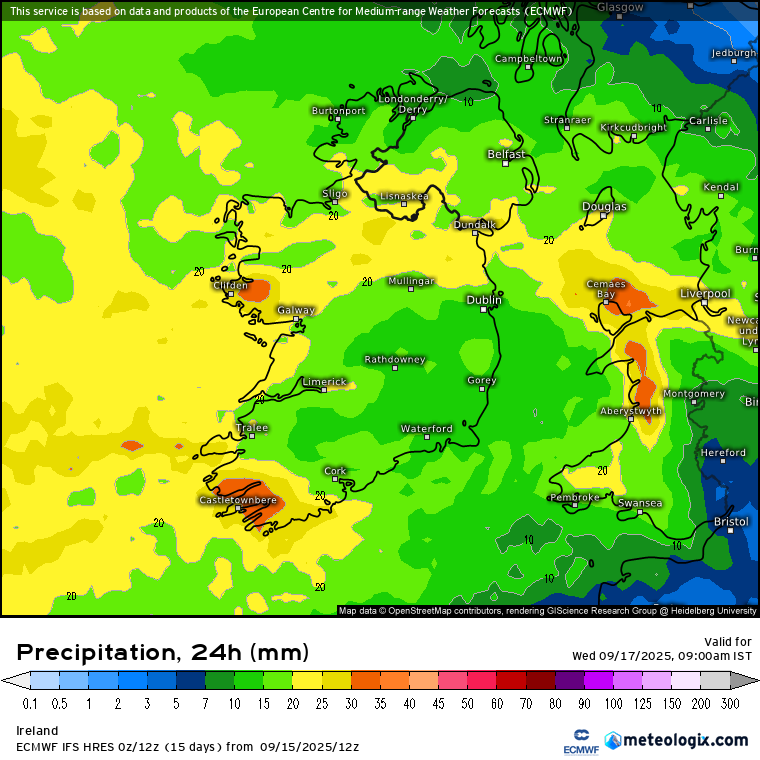
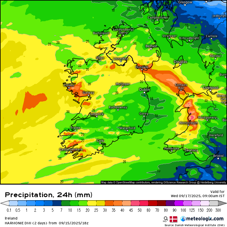
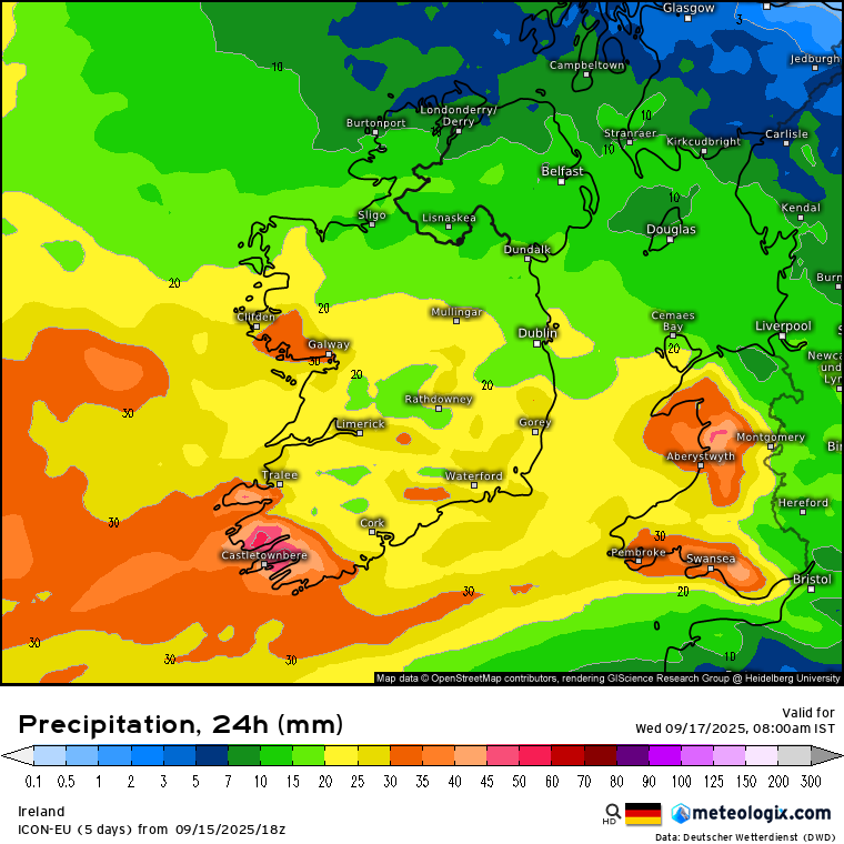
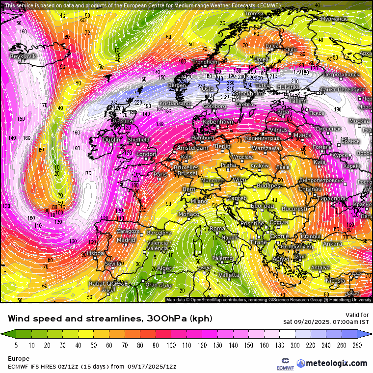
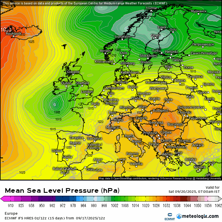
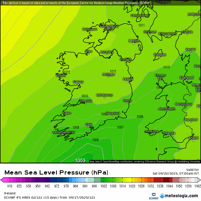
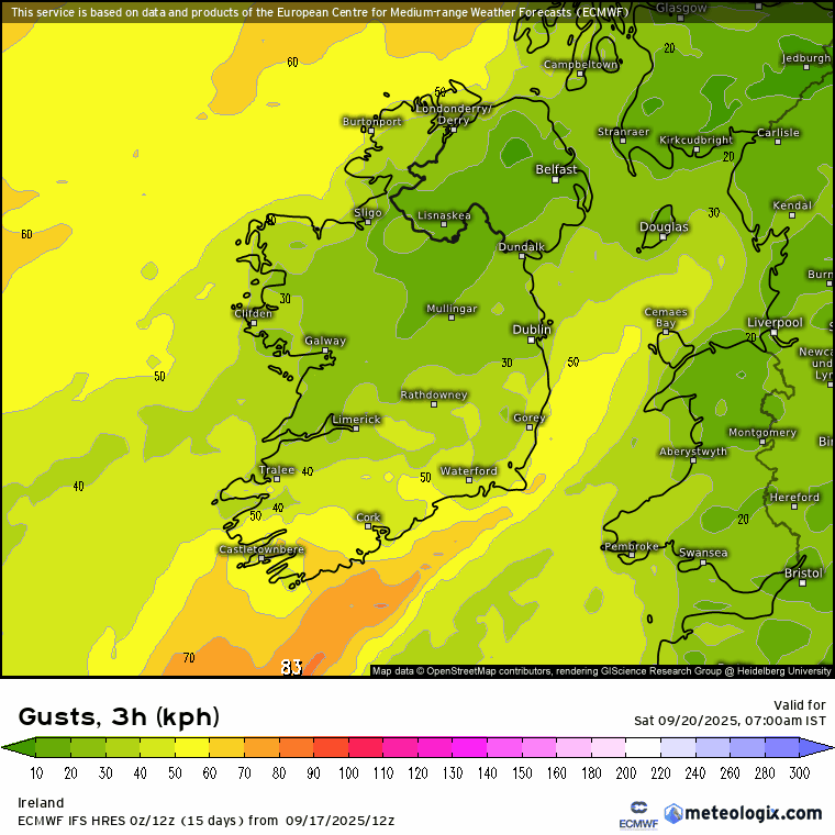
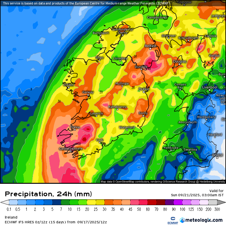
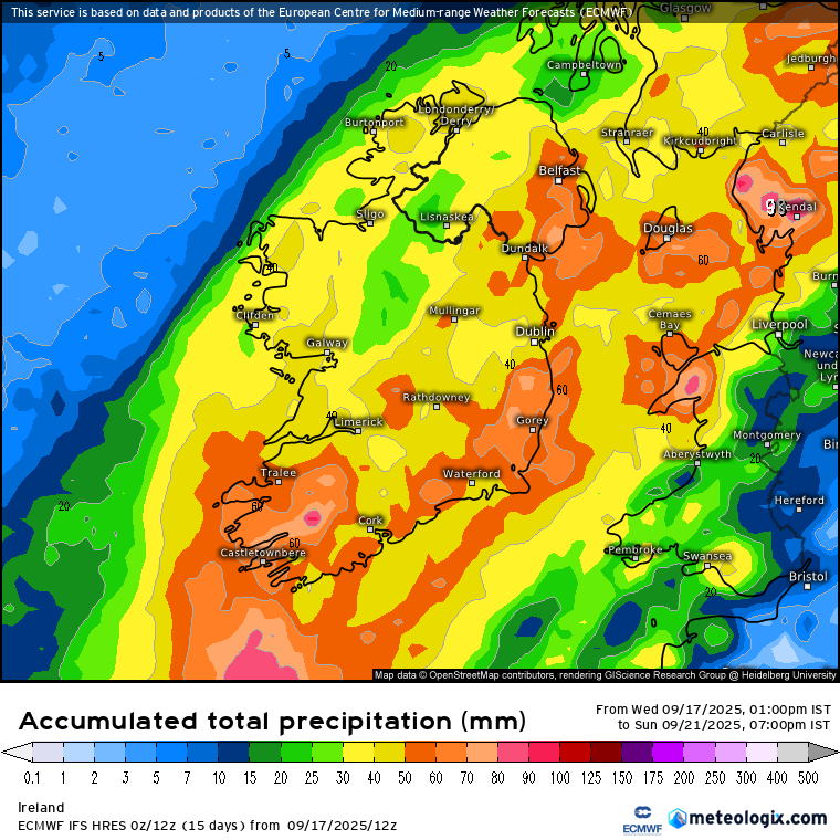
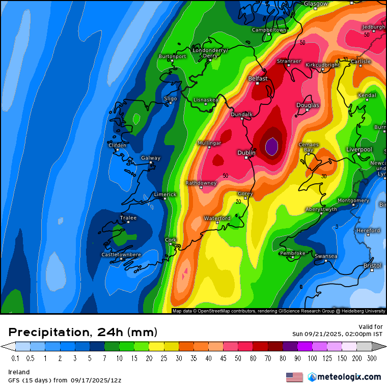
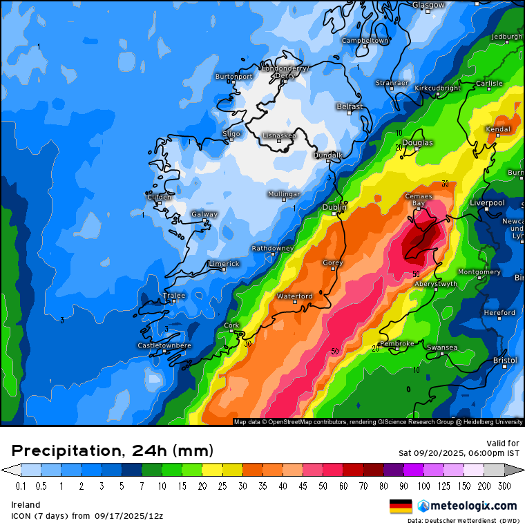
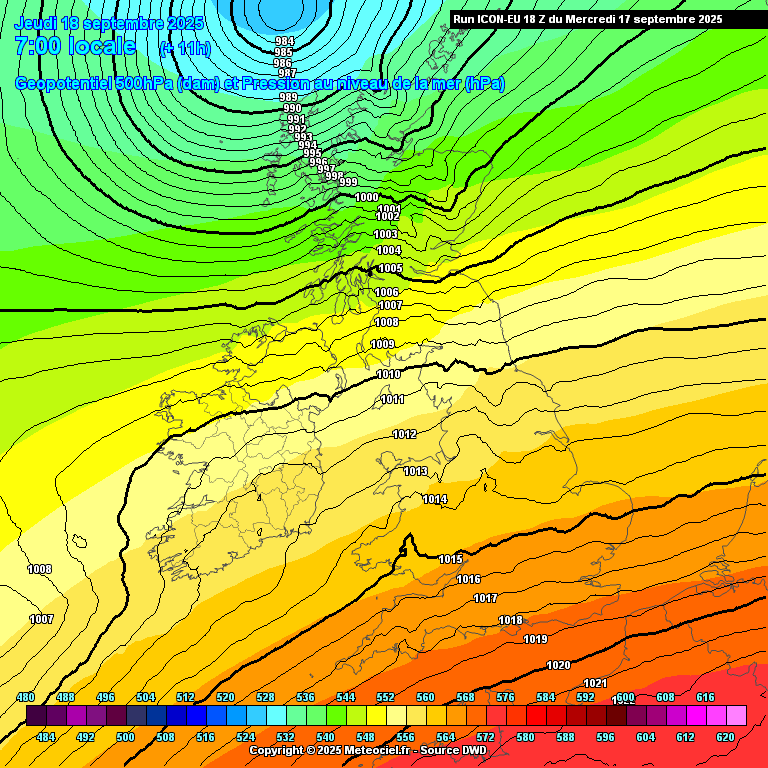
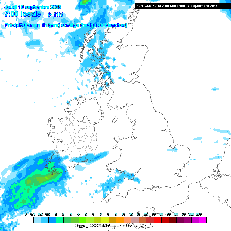
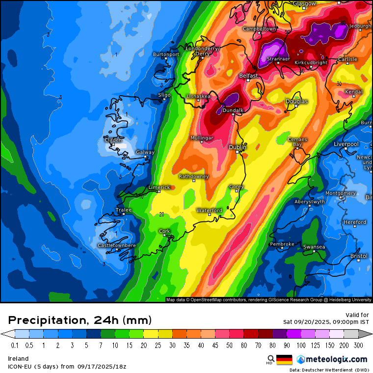
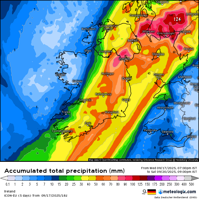
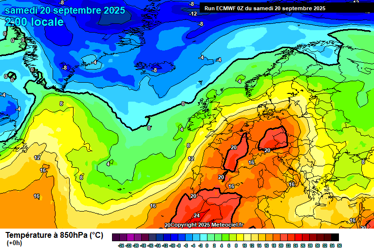
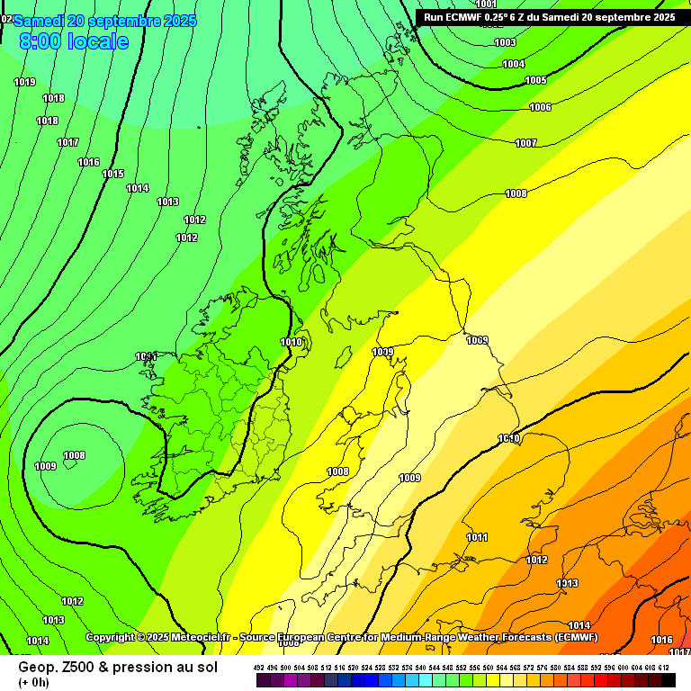
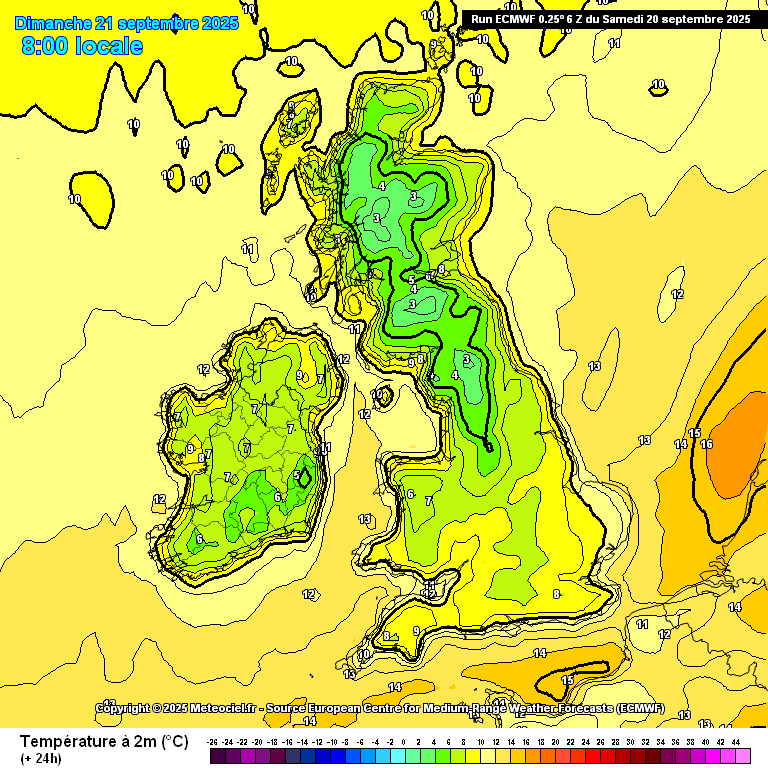
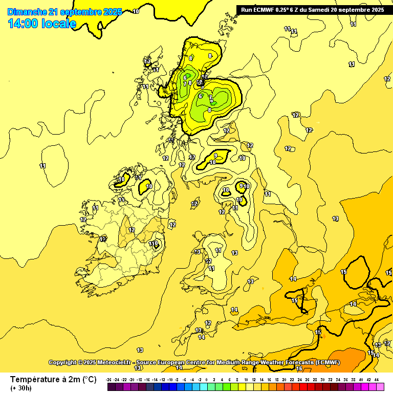
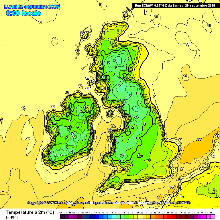
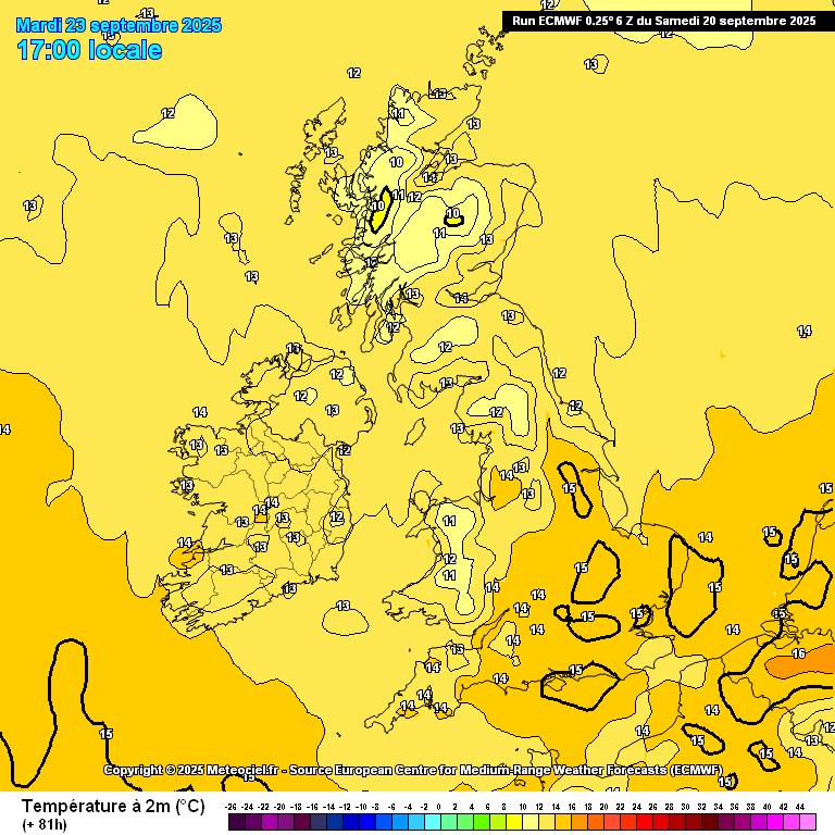
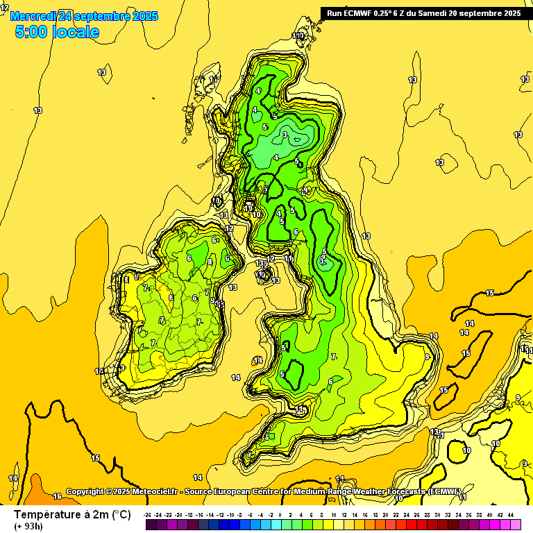
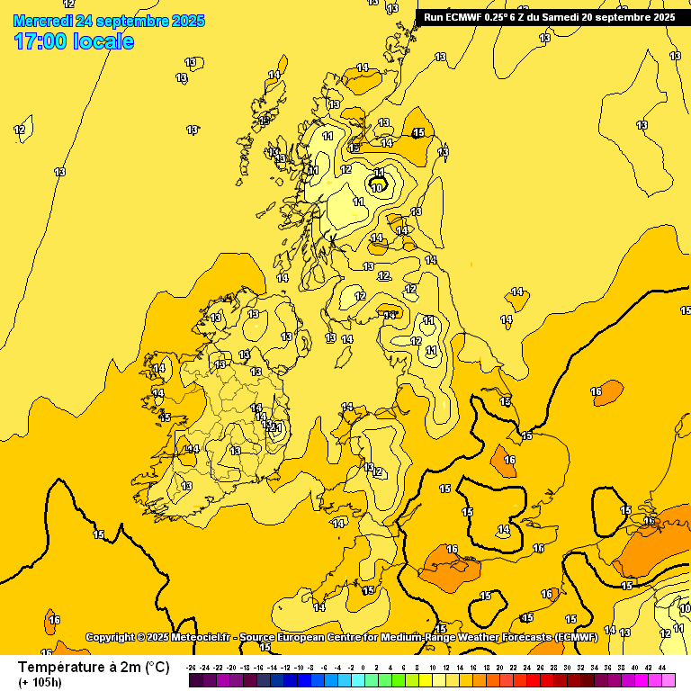
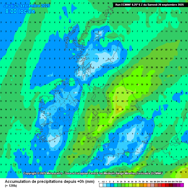
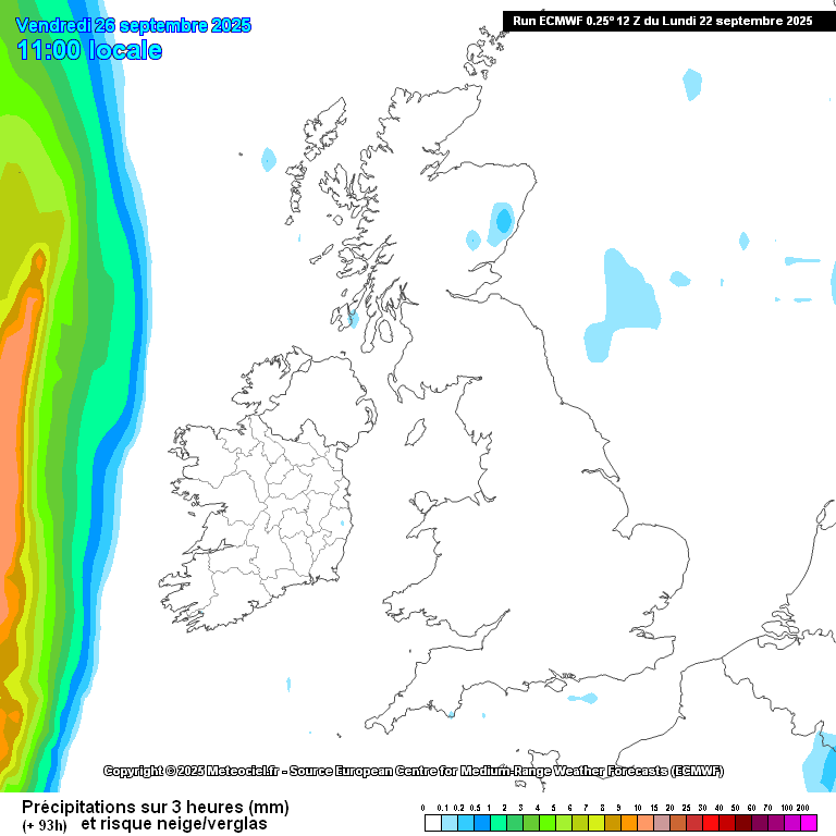
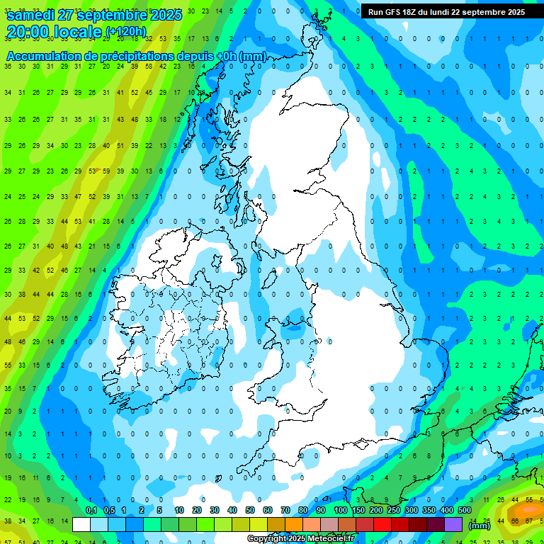
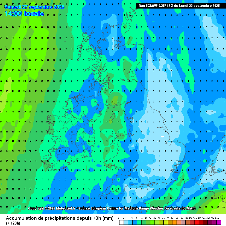
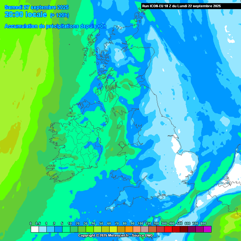
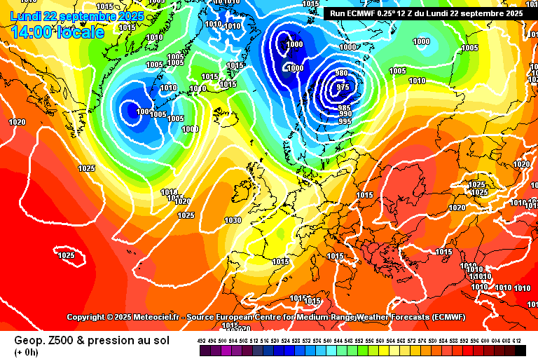
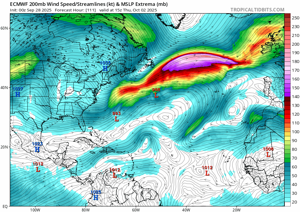
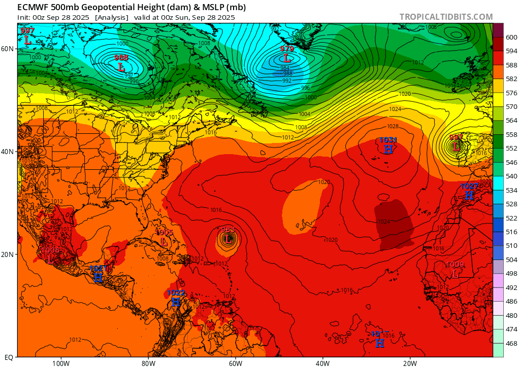
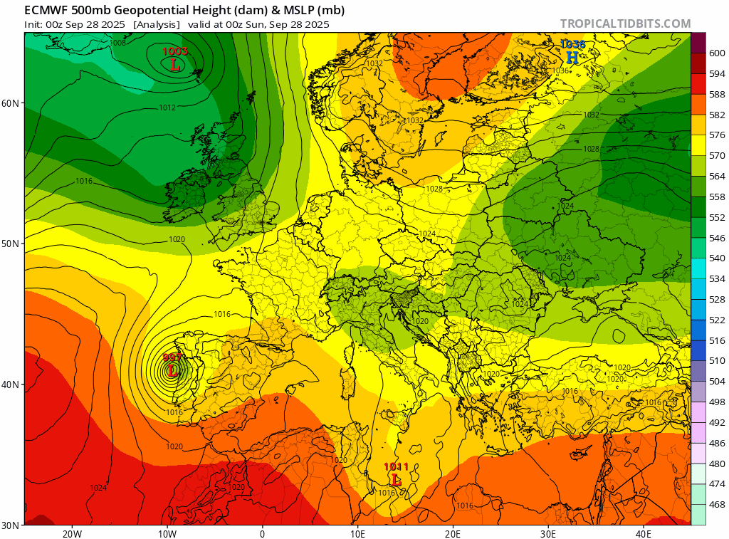
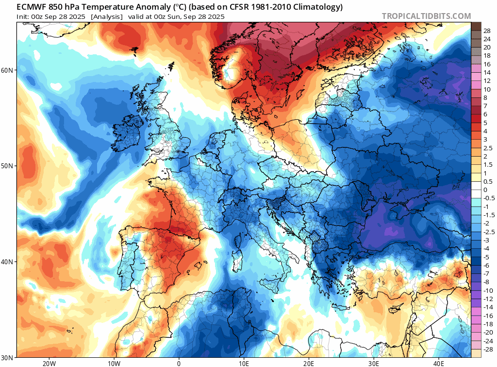
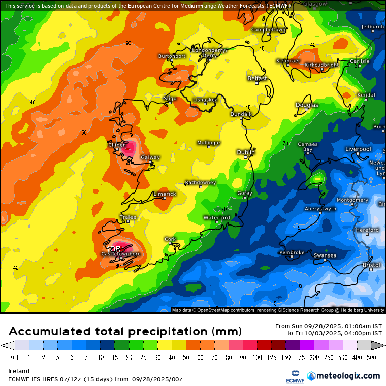
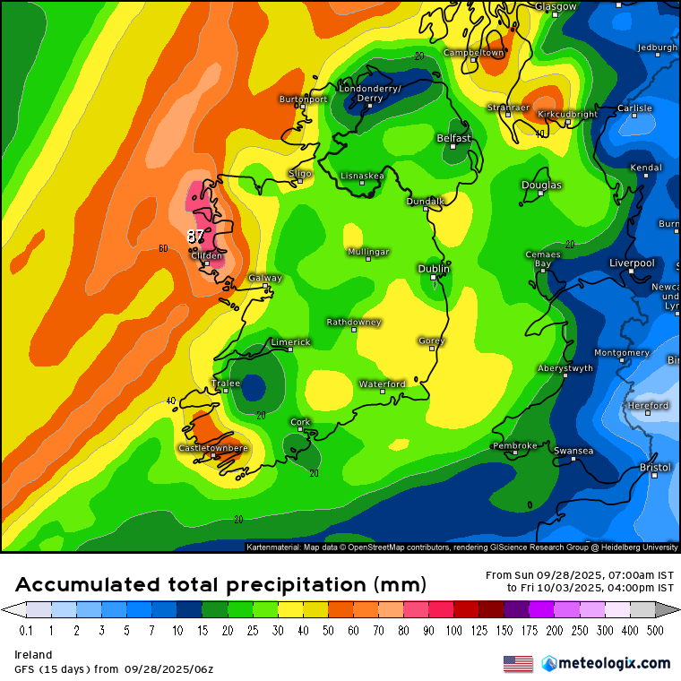
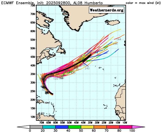
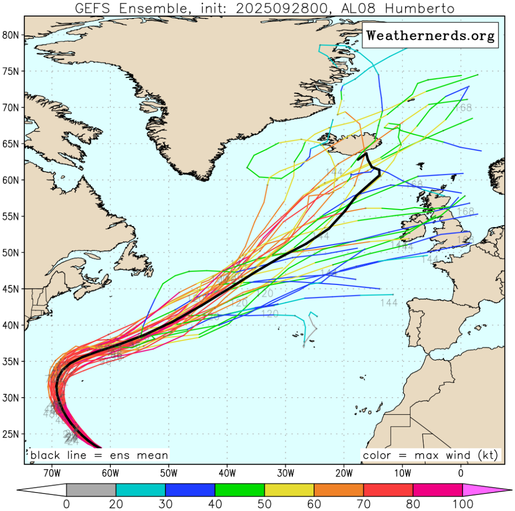
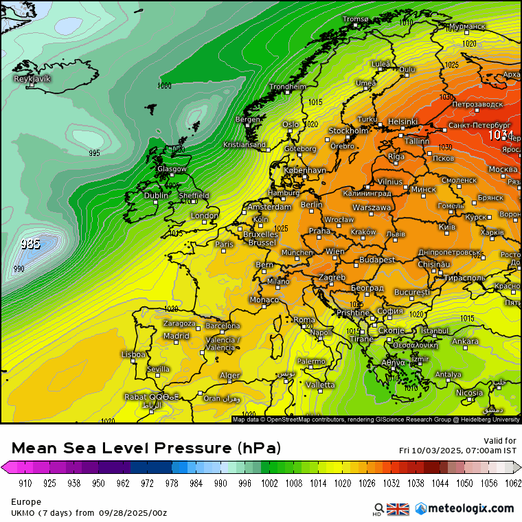
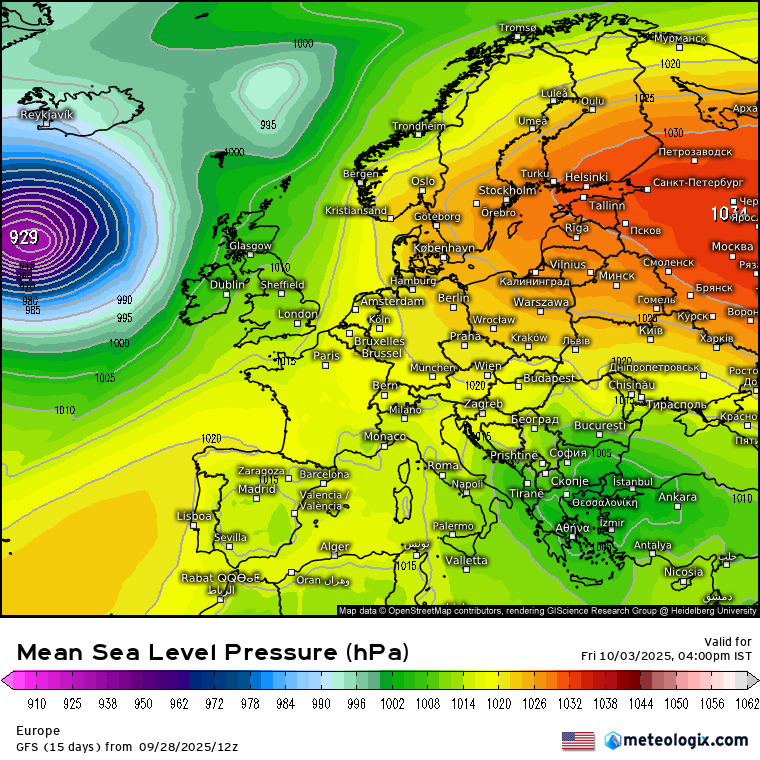
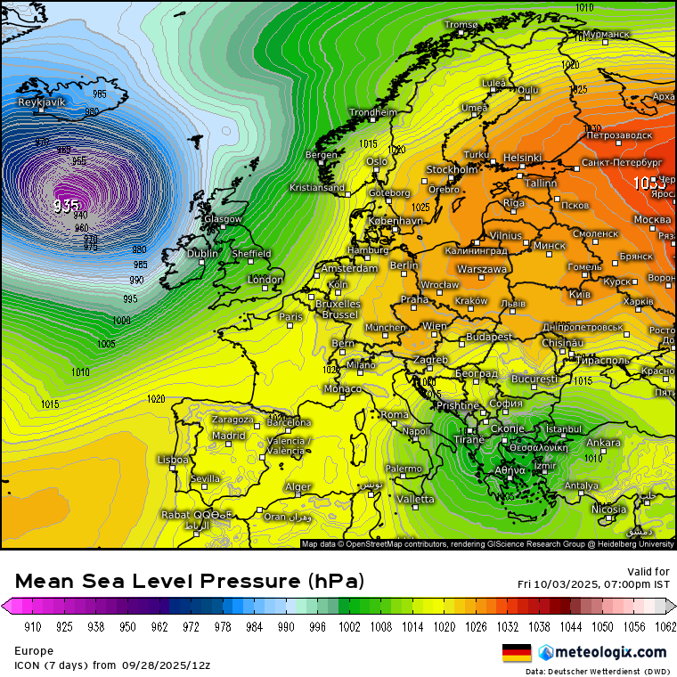
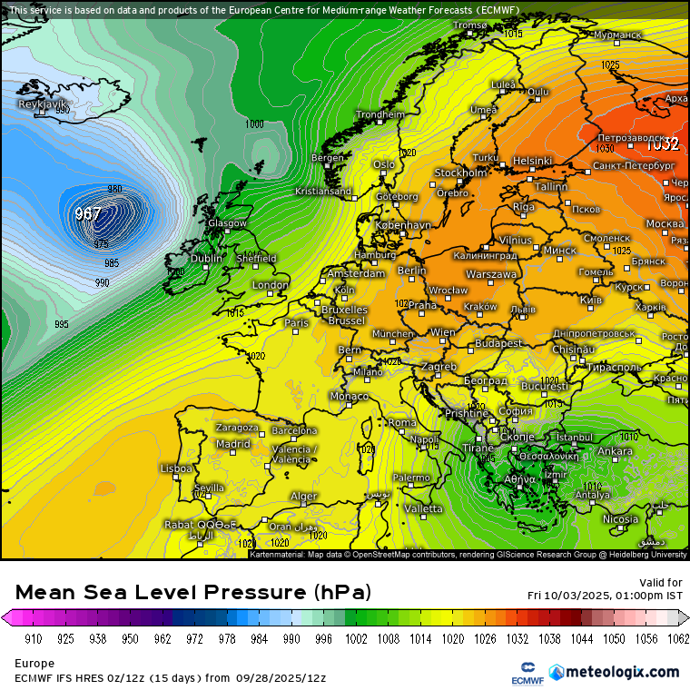
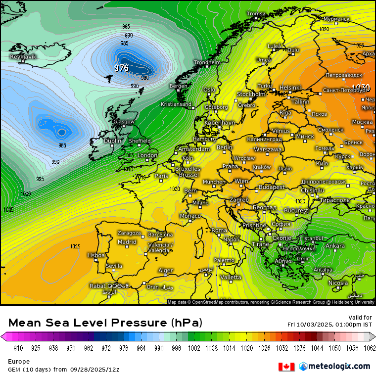
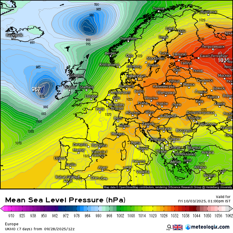
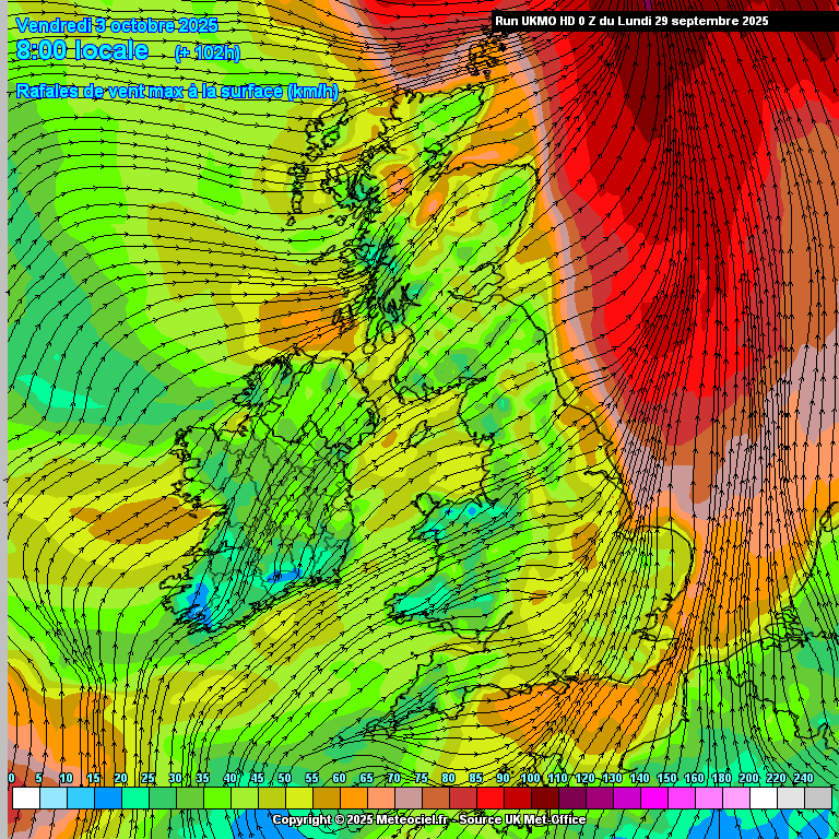
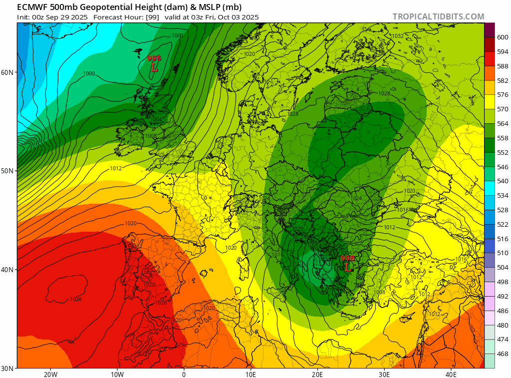
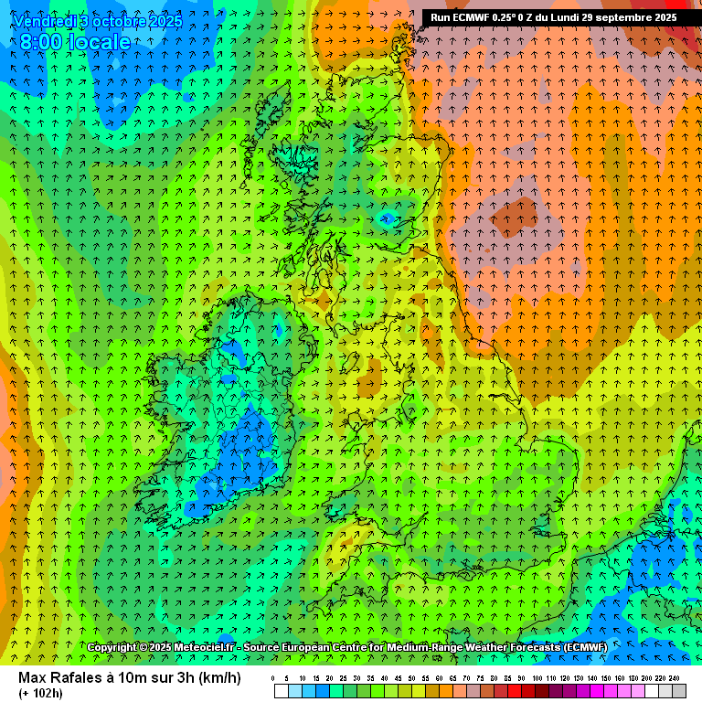
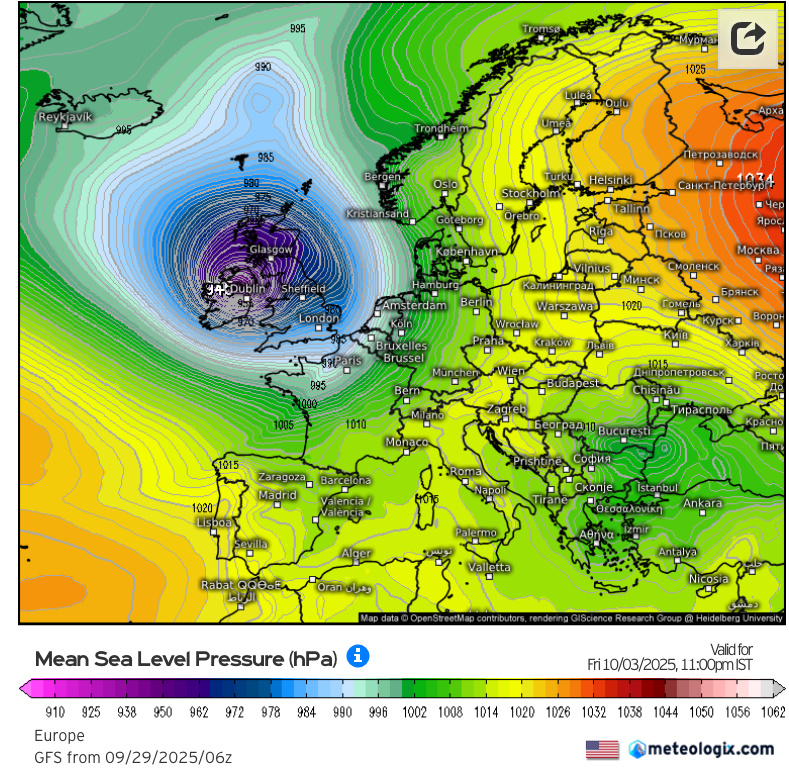
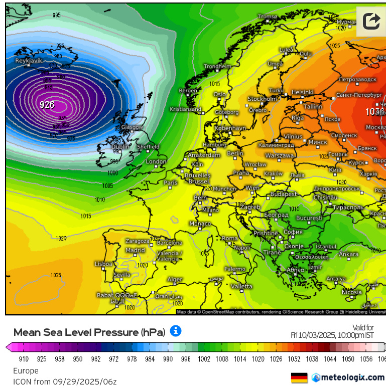
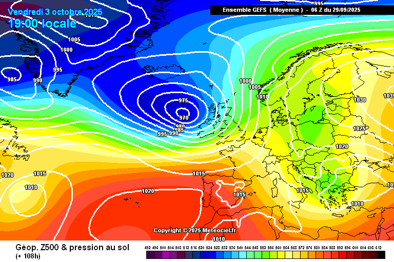
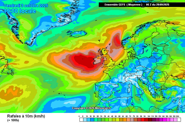
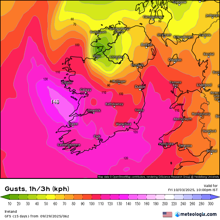
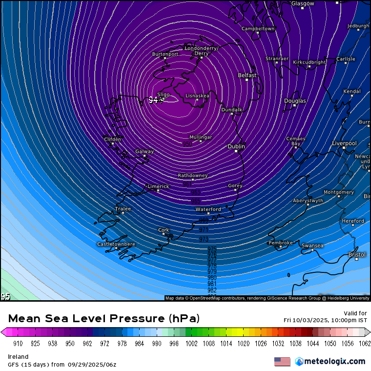
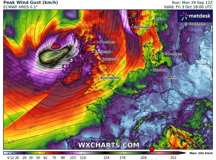
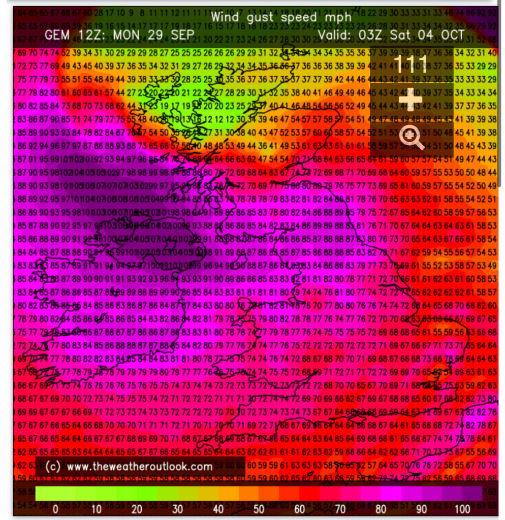
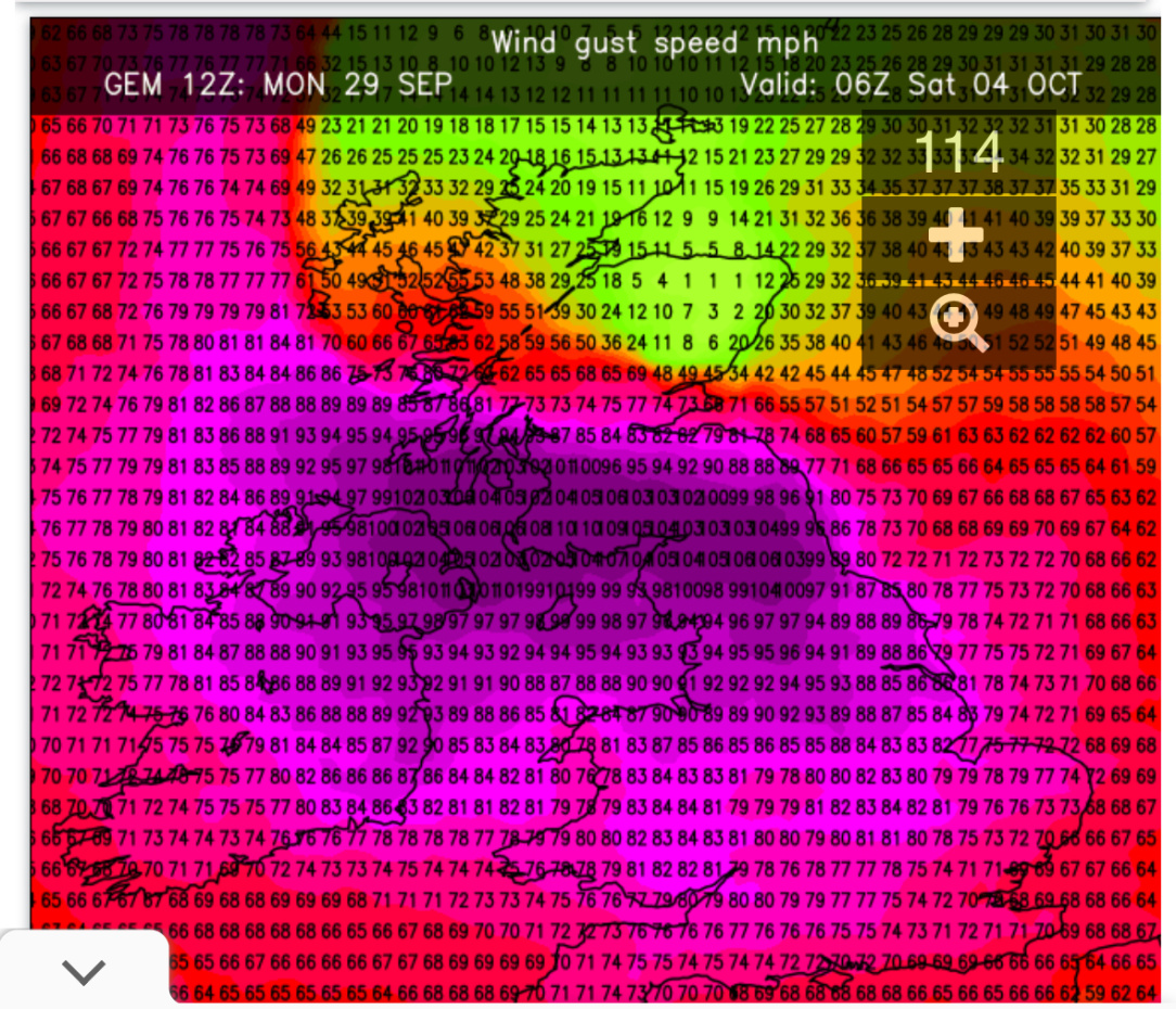
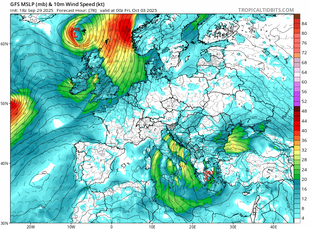
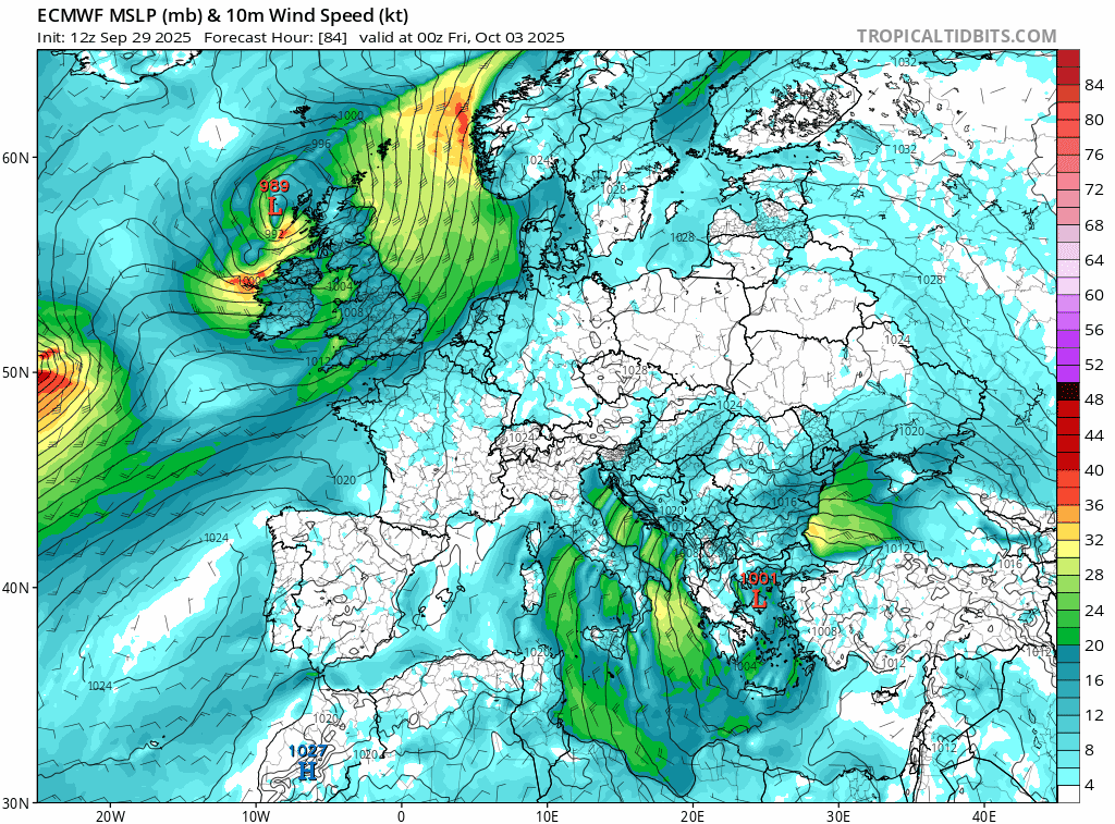
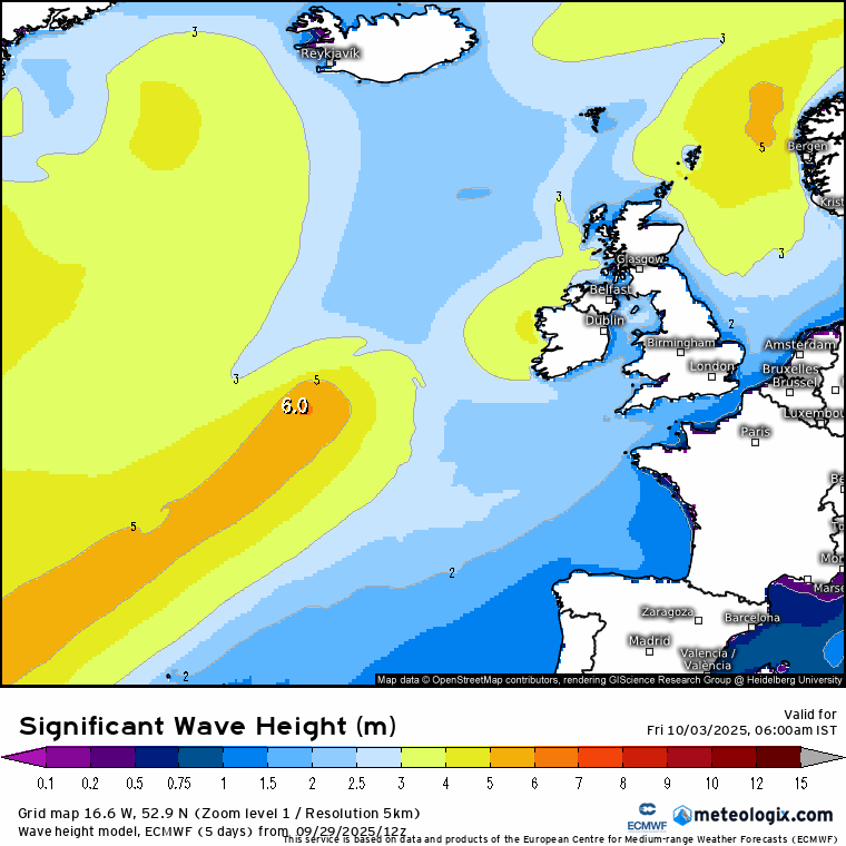
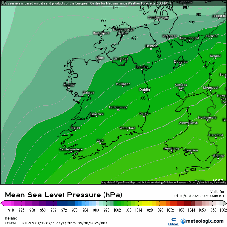
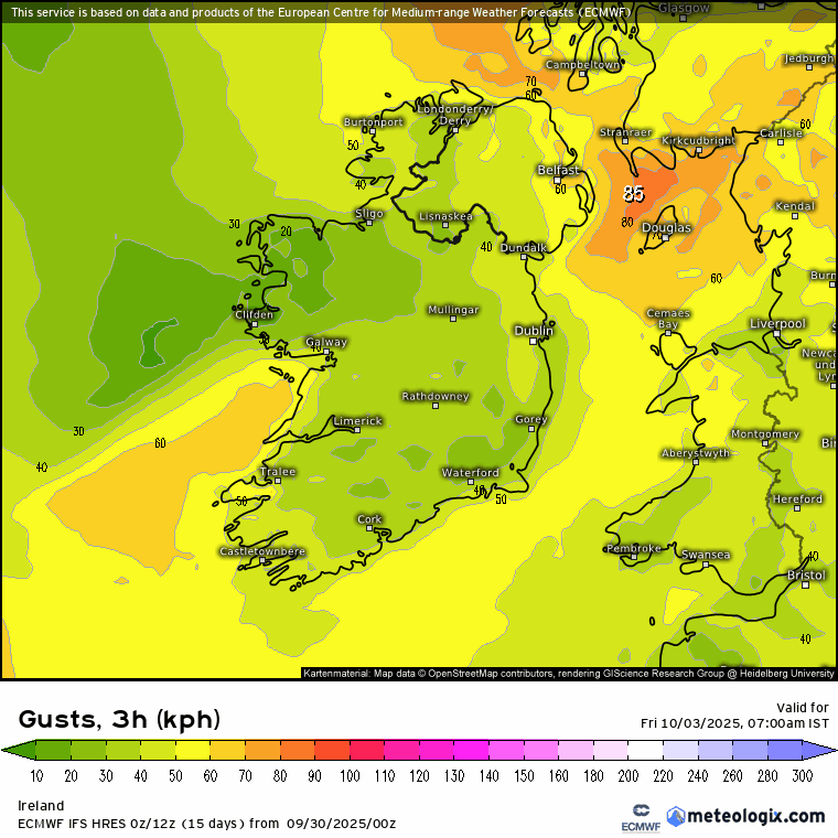
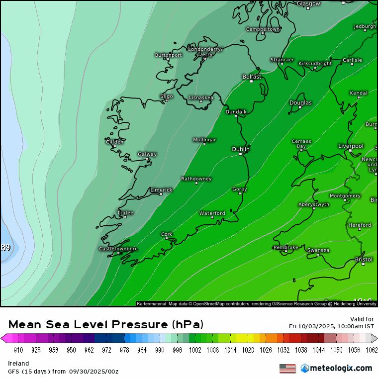
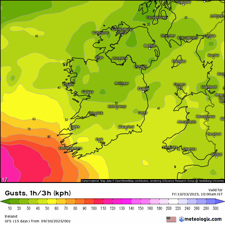
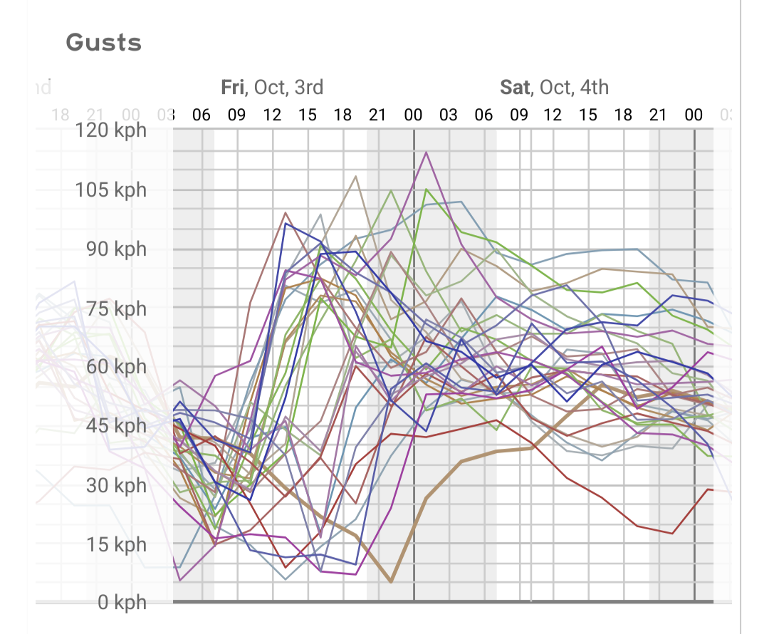
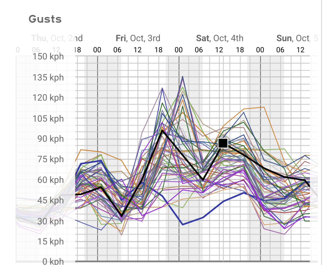
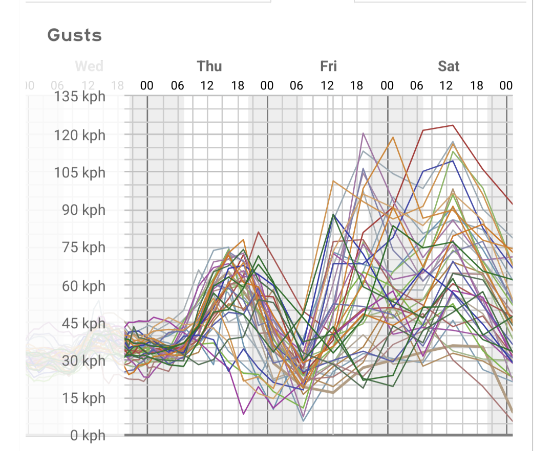
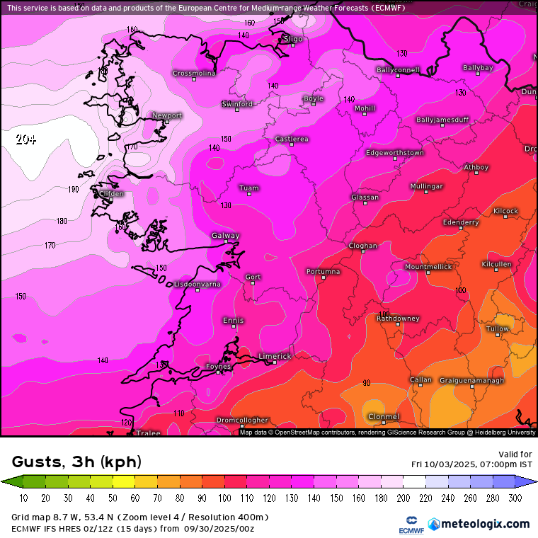
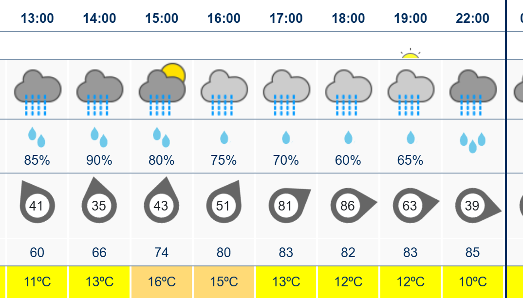
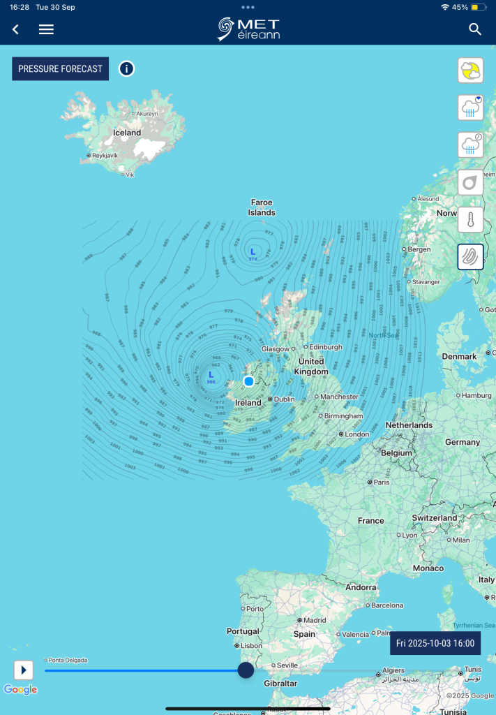
Charts ( up to T120) Autumn 2025 **READ MOD NOTE IN FIRST

24

Comments

  • Moderators, Science, Health & Environment Moderators Posts: 13,104 Mod ✭✭✭✭Meteorite58


    Rainfall warnings for later Tues into Weds.

    image.png

    image.png

    xx_model-en-324-0_modusa_2025091518_36_949_63.png xx_model-en-324-0_modukmo2km_2025091518_36_949_63.png

    xx_model-en-324-0_modez_2025091512_44_949_63.png

    xx_model-en-324-0_modhardmi_2025091518_38_949_63.png xx_model-en-324-0_moddeuhd_2025091518_37_949_63.png


  • Moderators, Science, Health & Environment Moderators Posts: 13,104 Mod ✭✭✭✭Meteorite58


    Even at this late stage huge uncertainty about the weather over the weekend especially Saturday. Models have been changing track by the run but they were mostly all showing potential for some significant falls of rain over a relatively short time and had been showing the chance of strong winds running down along the coasts from a Northerly direction.

    Most notably ECM 12Z showing it to be much windier on the latest run in parts overland and very windy in parts along the coasts but nothing certain as yet to where will get the strong winds or most rainfall as all depends how the LP evolves in such a complex set up, sandwiched between two arms of the the Jet moving in opposite directions .

    Just leading with the ECM as I think it might have a better handle on it but would expect a change in the look of the charts over the coming days one way or the other.

    UKMO similar winds but rainfall mostly in the E.

    GFS quite windy, more so in the Eastern half of the country and extremely wet in the East as the chart shows below.

    ICON not as windy and very wet in the SE.

    modez_20250921_1500_animation (3).gif

    modez_20250921_1500_animation (2).gif

    modez_20250921_1500_animation (1).gif modez_20250921_1500_animation.gif

    24hr precipitation

    xx_model-en-324-0_modez_2025091712_86_949_63.png

    Total accumulated precipitation

    xx_model-en-324-0_modez_2025091712_102_949_157.png

    xx_model-en-324-0_modusa_2025091712_97_949_63.png xx_model-en-324-0_moddeu_2025091712_77_949_63 (1).png


  • Moderators, Science, Health & Environment Moderators Posts: 13,104 Mod ✭✭✭✭Meteorite58


    Still evolving , ICON taking on more of the look of the GFS for highest rainfall totals, windy in the NE for a time on this one. Could be seeing some big rainfall totals. Weather forecast after the news mentioned uncertainty but highlighted the E and S getting the highest rain perhaps. Far from resolved yet.

    Untitled Image

    Untitled Image

    xx_model-en-324-0_moddeuhd_2025091718_74_949_63.png

    xx_model-en-324-0_moddeuhd_2025091718_74_949_157.png


  • Moderators, Science, Health & Environment Moderators Posts: 13,104 Mod ✭✭✭✭Meteorite58


    A couple of cooler days coming up in the N'ly breeze as HP becomes dominant , best chance of a ground frost early Mon morning, a bit milder from around Tues as the winds switch around more S'ly getting up to 13 to 15C or so, after todays rain remaining dry for most out to +120hrs , Thurs, cooler longer nights in single digits now as we ease into Autumn.

    Untitled Image

    Untitled Image

    Untitled Image

    Untitled Image

    Untitled Image

    Untitled Image

    Untitled Image

    Untitled Image

    Untitled Image


  • Moderators, Science, Health & Environment Moderators Posts: 13,104 Mod ✭✭✭✭Meteorite58


    Some frontal rain possible Fri by the European models , GFS for now holding it off the coast. Will see, ECM, UKMO a bit blustery in parts on Fri but nothing too strong at this stage, GEM the stronger one showing a sharp little LP deepening closing in on Ireland but too early to know at this stage.

    Could see it getting up to 17C or so in parts Weds to Fri with cool nights.

    Ex Gabrielle looks to dissipate after the Azores on its way to Biscay. GFS on board with this scenario now too.

    Untitled Image

    Untitled Image

    Untitled Image

    Untitled Image

    Untitled Image


  • Advertisement
  • Registered Users, Registered Users 2 Posts: 6,260 ✭✭✭Chris_5339762


    Now now… lets have the nice weather continue for the weekend please Mr Jetstream


  • Moderators, Science, Health & Environment Moderators Posts: 17,884 Mod ✭✭✭✭Gonzo


    Dunshaughlin Harvest Festival this weekend, really hope that rain stays away until next week.


  • Moderators, Science, Health & Environment Moderators Posts: 13,104 Mod ✭✭✭✭Meteorite58


    Becoming unsettled as the week progresses , mostly dry today and tomorrow but picking up frontal waves at times for the rest of the week as the Atlantic becomes more mobile, clear spells also so not a total washout but when it rains it looks moderate to heavy at times in those moisture rich SW'lys. In general looks quite mild for the time of the year, not a huge diurnal range, getting into the mid teens during the day and not dropping too low at night, seeing temps around 10C or so overnight. Becoming quite wet especially the further W as the week goes on. Big uncertainty with Extratropical Humberto at the end of the week, just outside the +120hrs but including here as could have an effect on model output over the coming days. ECM showing its remaining energy getting directed and squeezed in over Ireland with wet and windy weather but not stormy, showing some high rainfall totals whereas the GFS shows it as storm on its track up by Scotland and sending in windy weather over us but not stormy so models couldn't be more different in track and shape. ECM and GFS accumulation charts below are on the lower side with other models showing much higher totals but they are probably the best to use as a marker and a guide at this stage.

    So models will probably be showing much different output as the week goes on and will be interesting to see how they handle and process the effects from Humberto entering our latitude . With that energy around towards the end of the week could easily see spin off lows and waves forming, I would think rainfall could become a bit of an issue as totals climb and the land becomes saturated towards the end of the week and will see how much rainfall the remnants of Humberto brings to us but not all hinging on it either as the weather pattern in its own right becomes unsettled coming across the Atlantic.

    Adding the UKMO also. At this stage big uncertainty but it is showing a similar track to the ECM of Extratropical Humberto but more organized in this run, showing stormy over Ireland and very wet . ICON a different shape again more to the W but a lot of energy and wide wind field , wet and windy also, showing high totals up to Fri and very wet at times over the weekend .

    ecmwf_uv200_atl_fh111-144.gif ecmwf_z500_mslp_atl_fh0-144.gif ecmwf_z500_mslp_eu_fh0-120.gif ecmwf_T850a_eu_fh0-120 (1).gif

    Untitled Image

    xx_model-en-324-0_modez_2025092800_135_949_157.png xx_model-en-324-0_modusa_2025092806_129_949_157.png

    AL08_2025092800_ECENS.png

    AL08_2025092800_GEFS_large.png modgbr_20251003_0900_animation (1).gif


  • Registered Users, Registered Users 2 Posts: 914 ✭✭✭Robwindstorm


    The weekly weather on RTE with Mark Bowe was a bit all over the place. He has the weekly rainfall chart giving totals 300% of normal for over half of the country and 150 to 180% for the rest. The forecast only stretched until Wednesday where from the midlands to east has little rainfall showing. I assume most of this rain is coming towards the end of the week including Humberto's remains. It's a wait and see. Either way, the west of the country looks like it's going to be miserably wet and manky.


  • Registered Users, Registered Users 2 Posts: 6,174 ✭✭✭Storm 10


    It was the worst forecast that I have seen from ME as you say all over the place they normally go to the end of the week but stopped at Friday, so much for their state of the art equipment they have.


  • Advertisement
  • Registered Users, Registered Users 2 Posts: 7,451 ✭✭✭pad199207


    Do people still watch those televised forecasts after they changed the graphics?


  • Moderators, Science, Health & Environment Moderators Posts: 13,104 Mod ✭✭✭✭Meteorite58


    ECM closer in line now with the GFS and ICON keeping the storm well off to the West, breezy to blustery overland but nothing too strong apart from near the coasts a bit windy . GEM giving wet and windy weather.

    Will see what UKMO does later.

    xx_model-en-324-0_modusa_2025092812_123_1642_149.png

    xx_model-en-324-0_moddeu_2025092812_126_1642_149.png

    xx_model-en-324-0_modez_2025092812_120_1642_149.png

    xx_model-en-324-0_modcan_2025092812_120_1642_149.png


  • Moderators, Science, Health & Environment Moderators Posts: 13,104 Mod ✭✭✭✭Meteorite58


    UKMO 12Z , so the main models agreeing on general track of Ex Humberto but all depends how close it comes to our shores, UKMO has it deepening passing Ireland and still showing stormy conditions over parts of Ireland, long way to go though.

    xx_model-en-324-0_modgbr_2025092812_120_1642_149 (1).png


  • Registered Users, Registered Users 2 Posts: 455 ✭✭Ros4Sam24


    Thursday- one of the only days of the year I need to be dry and we’re looking at over 30mm for a lot of the country… nice. The start of October looks to be following September in having a dreadful start to the month with the weekend looking poor aswell 😕

    IMG_0925.jpeg


  • Moderators, Science, Health & Environment Moderators Posts: 13,104 Mod ✭✭✭✭Meteorite58


    As MT was saying in the forecast thread some models now bringing the remnants of Humberto in over Ireland giving stormy conditions on the latest runs but still a divide in the charts so nothing certain but certainly worth keeping a watch on. GFS capturing the disturbed weather from Thurs out ahead of Extratropical Humberto, ICON quite similar to GFS but ECM now taking a track more or less half way between Ireland and Iceland. ACCESS-G also showing very windy /stormy for Ireland on Fri. GEM a whole different shape and only deepening past Ireland.

    Time will tell.

    gfs_z500_mslp_eu_fh78-138.gif

    Untitled Image

    moddeu_20251004_2100_animation.gif

    Untitled Image

    ecmwf_z500_mslp_eu_fh99-132.gif

    Untitled Image


  • Registered Users, Registered Users 2 Posts: 455 ✭✭Ros4Sam24


    @Meteorite58 6z Gfs and icon following suit…

    IMG_0930.jpeg IMG_0929.jpeg

    The record lowest pressure reading for Ireland in October in 957.5 and all time record is 931.2 . Still a ways to go till Friday 😅

    Post edited by Ros4Sam24 on


  • Moderators, Science, Health & Environment Moderators Posts: 1,663 Mod ✭✭✭✭WolfeEire
    Clare (430ft asl)


    The latest GEFS mean looks fairly ominous

    gens-31-1-108.png gens-31-8-108.png

    www.weatheire.com


  • Registered Users, Registered Users 2, Paid Member Posts: 14,276 ✭✭✭✭sryanbruen


    Friday is October however, not September.

    The October record is 957.5 mb which it would still absolutely obliterate.

    GFS 06z mean does look bad but the OP is bottom end of the range.

    Photography site - https://sryanbruenphoto.com/


  • Registered Users, Registered Users 2 Posts: 2,255 ✭✭✭adocholiday


    Serious drop in pressure with this one looking at the charts. ECM has a massive 52hPa drop from 10pm Thursday to 10pm Friday, GFS 44hPa drop in the same timeframe and it's a direct hit. Explosive cyclogenesis is defined as a 24hPa drop in 24 hours so this is nearly double that. Galway Beo and their ilk I'm sure will have some scare mongering 'weather bomb' headlines if this comes near our shores but at the moment if the GFS 06z were to be accurate we'd be looking at potential red warnings for the Southern half of the country.

    xx_model-en-324-0_modusa_2025092906_111_949_254.png xx_model-en-324-0_modusa_2025092906_111_949_149.png


  • Registered Users, Registered Users 2, Paid Member Posts: 366 ✭✭ascophyllum


    The ECM 06z has a crazy low of <940 a few hundred miles off the NW coast, winds of 140 gusting to 190 kmph on its southern edge, far enough away for now not to bother Ireland, prob 100km gusts in the NW but interesting to see the next few days of modelling.


  • Advertisement
  • Registered Users, Registered Users 2 Posts: 455 ✭✭Ros4Sam24


    We are seriously playing with fire on Ecm… holy Moses

    IMG_0932.jpeg


  • Registered Users, Registered Users 2 Posts: 3,232 ✭✭✭.Donegal.


    GEM looks insane. Pretty much a country wide red. Gusts are mph. 93mph/150km/h over Dublin. 105 or 107mph overland across Ulster if my eyes are seeing it right.

    IMG_4510.jpeg IMG_4509.jpeg IMG_4511.jpeg


  • Registered Users, Registered Users 2 Posts: 3,925 ✭✭✭Dazler97


    I hope it doesn't come off 😕 I don't want a storm anytime soon , although I'm prepared for power cuts anyway loads of candles, proper duracell batteries and superser there for heat, that's quite a strong low and especially so for early October


  • Registered Users, Registered Users 2 Posts: 6,174 ✭✭✭Storm 10


    ME no mention but BBC1 forecast mentioned it could become quite stormy


  • Moderators, Science, Health & Environment Moderators Posts: 13,104 Mod ✭✭✭✭Meteorite58


    Still not cross model agreement in the track of the remnants of Humberto, as mentioned GEM showing strong winds and now ICON 18Z showing very stormy conditions Fri into Sat but models are still very much evolving. Latest ECM on the other hand shows less strong winds overland, windy all right in coastal areas, likewise UKMO not too windy away from the coasts, ACCESS-G a new shape to it being much different now to the rest on the latest run so a bit of an outlier although still showing some strong winds.

    GFS 12Z was very strong and stormy in parts especially over the Northern half of the country, 18Z run just rolling out and looks to be taking a similar track to the ECM keeping the strongest winds away from the country, windy overland for a time but not stormy overland on this one. Also it keeps the storm moving N and not taking a turn to the E like on earlier runs which doubled the strong winds back in over Ireland.

    Looking at the charts and reading the National Hurricane Centre Humberto is entering an area of high shear which is forecast to continue and has begun to weaken the system and as it moves into the Northern Atlantic and colder waters it will get picked up by a trough and get absorbed and begin to accelerate in an NE direction whilst developing frontal features. The NHC mention the track and evolution of GFS and ECM models '

    In about 60 h, both the GFS and ECMWF guidance depict that the system should merge with the previously mentioned trough digging across the north Atlantic and develop frontal features. As the system becomes extratropical across the north Atlantic, the wind field is anticipated to grow in size. The latest NHC intensity forecast lies on the higher end of the guidance envelope given the latest increase in intensity, and then shows weakening throughout the period. By 96h, the system is expected to dissipate and merge within the larger trough.
    

    So ECM, GFS, UKMO all showing a track keeping the strongest storm force winds off shore , strong along coastal areas ( maybe up to Orange ) and yellow in over Ireland at this stage. ICON, GEM very strong in the high warning levels but would have to lean towards the main models at this stage anyway but as ever a long way to go and the main models could easily change track again.

    In neaps at present but tides getting higher again during the weekend so coastal overlapping may be a concern. Some big seas showing up on the prediction charts.

    Will message MT and ask him to consider starting a dedicated Storm Watch thread tomorrow if the morning models warrant it.

    gfs_mslp_wind_eu_fh78-120.gif ecmwf_mslp_wind_eu_fh84-120.gif

    modwaveecmwf_20251003_0500_animation.gif


  • Moderators, Science, Health & Environment Moderators Posts: 13,104 Mod ✭✭✭✭Meteorite58


    Models in total disarray this morning re Friday/ Saturday, tracks all over the place and from full on high impact storm to just a breezy / windy spell.

    ECM showing a massive shift and showing the strongest winds in a head on collision with Ireland but this run is against the trend up to this morning so would need to see a similar chart on next run to have any faith in it. Will include for comparison sake but more than likely to change.

    GFS less structured , not as closed and tightly compact as ECM but similar track bringing less strong winds in over Ireland although still windy enough, will see if there is more alignment in next run.

    modez_20251003_1100_animation.gif modez_20251005_0300_animation.gif modusa_20251005_0000_animation-1.gif modusa_20251005_0000_animation.gif


  • Registered Users, Registered Users 2, Paid Member Posts: 366 ✭✭ascophyllum


    Very strange to have such a large spread these days at just 84 hours. Icon 6z has the low only deepening past Scotland, whereas ECM has Eowyn 2.0 off Mayo. GFS dropping it a bit south, still very strong.


  • Registered Users, Registered Users 2 Posts: 2,255 ✭✭✭adocholiday


    Even the ensembles are still very scattered for each of the models so they have hardly any consistency. The following ensembles are for Mullingar near the middle of the country. ECM a little more clustered than GFS and ICON. Still a good bit to go to see how this plays out. I'd be very concerned for Western areas if something like the ECM were to happen though, most trees are still very much in leaf and with winds that high that area could see some very significant disruption and it's just on the tail end of the commute time too. Towns like Clifden and Westport potentially seeing 170kmh gusts for a few hours.

    I'll refrain from ramping, I don't tend to be a ramper anyway but if this takes a southerly track and deepens as modeled then it needs to be seen as potentially very impactful storm.

    GFS:

    Screenshot_20250930-112531.png

    ECM:

    markup_1000082459.png

    ICON:

    markup_1000082458.png xx_model-en-324-0_modez_2025093000_90_20670_93.png


  • Registered Users, Registered Users 2 Posts: 2,733 ✭✭✭crusd


    I am presuming Met Eireann dont use ECM given the below is the current forecast for Westport Friday?

    image.png


  • Advertisement
  • Registered Users, Registered Users 2 Posts: 3,925 ✭✭✭Dazler97


    I can see a weather advisory being issued tomorrow if models still show a low pressure coming in from the west southwest , quite tightly packed isobars around Galway similar to eowyn in January but at least pressure isn’t as low

    IMG_0264.png


Advertisement