Advertisement
If you have a new account but are having problems posting or verifying your account, please email us on hello@boards.ie for help. Thanks :)
Hello all! Please ensure that you are posting a new thread or question in the appropriate forum. The Feedback forum is overwhelmed with questions that are having to be moved elsewhere. If you need help to verify your account contact hello@boards.ie
Hi all,
Vanilla are planning an update to the site on April 24th (next Wednesday). It is a major PHP8 update which is expected to boost performance across the site. The site will be down from 7pm and it is expected to take about an hour to complete. We appreciate your patience during the update.
Thanks all.

N22 - Macroom to Ballyvourney (Macroom Bypass) [open to traffic]

1575860626394

Comments

  • Moderators, Entertainment Moderators, Science, Health & Environment Moderators Posts: 14,344 Mod ✭✭✭✭marno21


  • Registered Users Posts: 34 FreedomOfSpeechAndChoice


    Great. Although OSM currently shows it as a roundabout under construction.


  • Registered Users, Moderators, Sports Moderators Posts: 7,283 Mod ✭✭✭✭yerwanthere123


    Thanks Marno. So unless I'm misunderstanding you, that's three exits for 22 kilometres of road? Tbh I assumed there'd be a lot more.


  • Moderators, Entertainment Moderators, Science, Health & Environment Moderators Posts: 14,344 Mod ✭✭✭✭marno21


    OSM is incorrect here; the underbridge part of the grade separated junction is already built.


  • Moderators, Entertainment Moderators, Science, Health & Environment Moderators Posts: 14,344 Mod ✭✭✭✭marno21


    Two exits really as the western junction is really a terminal junction connecting the old N22 through Ballyvourney to the new route. The only other junction you could argue for would be a Macroom West junction at Carrigaphooca but the terrain around here is tricky for one.


  • Advertisement
  • Moderators, Entertainment Moderators, Science, Health & Environment Moderators Posts: 14,344 Mod ✭✭✭✭marno21


    Western junction diagram


  • Moderators, Entertainment Moderators, Science, Health & Environment Moderators Posts: 14,344 Mod ✭✭✭✭marno21


    Some detail on the new Toonlane junction east of Ballyvourney

    Roundabout interface with the existing N22 to be built in Q3.


  • Registered Users Posts: 2,455 ✭✭✭dmeehan


    Where did you get this diagram from, I'd like to see this detail for the other junctions


  • Moderators, Entertainment Moderators, Science, Health & Environment Moderators Posts: 14,344 Mod ✭✭✭✭marno21


  • Registered Users Posts: 5,849 ✭✭✭Chris_5339762


    Thats handy, thanks. I thought I looked for an EIS ages ago but couldn't find one. That detail is something thats been missing from this scheme.


  • Advertisement
  • Registered Users Posts: 4,675 ✭✭✭serfboard


    That's great, thanks very much for posting that. I too had assumed that OSM was correct.

    When you combine the Western end with the existing 2-3km of dual carriageway that's already there, it means that travelling West, after Coolcower, you'll have, what, 25km of dual carriageway? At a constant 100km, that's a 15 minute journey. Probably halving the time it takes now. Fantastic.

    Post edited by spacetweek on


  • Registered Users Posts: 34 FreedomOfSpeechAndChoice


  • Moderators, Entertainment Moderators, Science, Health & Environment Moderators Posts: 14,344 Mod ✭✭✭✭marno21


    2 lanes of road rather than dual carriageway, technically

    There’s approx 3km of climbing lane between the western terminus and the Kerry/Cork border near Christy Lucey Transport at the top of the hill. Add this to the scheme and you have 25km of twin lane road between Coolcower and Kerry, ideal for overtaking trucks, tractors, and trundlers. You can do this at the speed limit in 15 mins


  • Registered Users Posts: 5,849 ✭✭✭Chris_5339762


    The only thing we urgently need is a 3 lane motorway (has to be motorway) bypass of Glenflesk. Its unfair to expect drivers to slow down to 60kmh for all of a few hundred meters. We need a motorway there and a trumpet junction AT THE VERY LEAST.

    https://goo.gl/maps/Ti2GRbCJPi2cYZyk8


  • Registered Users Posts: 69 ✭✭confidentjosh


    🤣 You're hilarious Chris. A 3 lane motorway bypass for Glenflesk???? I'd love to know what you're smoking? 😂


  • Moderators, Entertainment Moderators, Science, Health & Environment Moderators Posts: 14,344 Mod ✭✭✭✭marno21


    Tarmac down on both sides of the road now as far as the Coolyhane Rd underbridge. That’s 2.3km of the route tarmaced now. It’s about 5.5km from Coolcower to Millstreet Road.

    Post edited by marno21 on


  • Moderators, Entertainment Moderators, Science, Health & Environment Moderators Posts: 14,344 Mod ✭✭✭✭marno21


    Corrected my earlier post, it's actually 5.5km from the eastern end to Millstreet Road. 2.3km of this has tarmac down, they are getting ready to lay the tarmac at Coolyhane Upper which is 3km from the eastern end and the concrete gullys are down at Kilnagurteen which is 4.8km from the eastern end. They're also flat out at the westbound on/off slips at Millstreet Road.

    Nearly time to start taking guesses on when Millstreet Rd-Coolcower will open at this rate

    (For reference, last week tarmac was down on both sides of the route for 800m and on the left hand part of the route for a total of 2.3km - its now fully tarmaced for 2.3km).


  • Registered Users, Moderators, Sports Moderators Posts: 7,283 Mod ✭✭✭✭yerwanthere123


    Thanks for all the updates Marno, very interesting to read. Do you reckon they'd really open Millstreet Road - Coolcower first? Would that not cause huge backlogs back the Millstreet Road with all the people coming off the new road?


  • Registered Users Posts: 4 bypasser


    The pavement layer being laid at the moment is called CBGM (cement bound granular material) and is now complete from Coolcour to Coolyhane Underbridge - this layer has to "cure" for 7 days before the blacktop layers of road base and binder course can be laid on it. The pavement makeup consists of 5 different layers = 150mm thick layer of Clause 808 stone, 170mm layer of CBGM, 85mm layer of road base tar, 55mm layer of binder course tar with the last layer being a 30mm thick layer of SMA wearing course tar. The laying of blacktop will commence from Coolcour heading west from late next week with the crew continuing to lay CL808 and CBGM from Coolyhane Underbridge to Ballyveerane and onwards.


  • Registered Users Posts: 44 peter.teahan


    As far as Millstreet / Rathmore traffic coming from Coolcour would be concerned this would be their new road complete as they would just head off to the right and only what's left for say Ballyvourney bound would head left back onto the existing N22.


  • Advertisement
  • Registered Users Posts: 1,440 ✭✭✭KrisW1001


    As most traffic between Rathmore/Millstreet to Cork already uses a rat-run via Masseytown Rd and the Mill Road to avoid Macroom town centre, this will have an additional benefit for people living along the northern edge of the town.

    I really don't think that bringing N22 traffic as far as the Millstreet Rd junction will cause any significant backlogs on the Millstreet Road itself: Joining N22 from the Millstreet Road right now, your biggest delaying factor is the long wait for a space in the stream of traffic coming from Macroom itself. Opening the new road will dramatically reduce that stream, and make that right-turn (for Kerry) much quicker it is at present. Coming the other way, it's a simple left turn.

    In any case, whatever traffic there it does cause would be a temporary situation, lasting for a year at most – and as compensation, the town itself will be freed from its appalling traffic problems a little earlier.


  • Registered Users Posts: 6,528 ✭✭✭kub


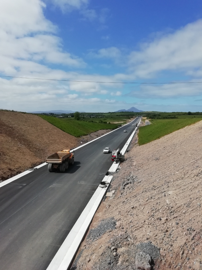
    I have just seen a post by the Principal contractor of this project in LinkedIn

    There is a picture of the road with very long section of it already with a layer of tarmac on it.

    What I am wondering is, is there not a concrete barrier going along the middle of that road ?

    Or does that get put on after the tarmac, just I would have assumed the concrete barrier would go first due to it needing a solid grounding


  • Registered Users Posts: 758 ✭✭✭DumbBrunette


    No, the N5 is the exact same, barrier to go down after:


  • Registered Users Posts: 5,849 ✭✭✭Chris_5339762


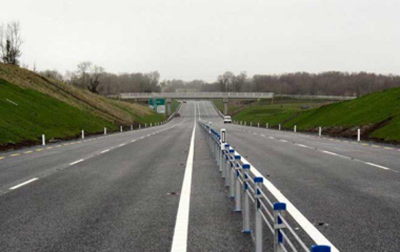
    2+2 roads like this have a wire barrier, not a concrete one. That gets drilled into the tarmac layer afterwards.


  • Registered Users Posts: 1,440 ✭✭✭KrisW1001


    Here's an example:


  • Registered Users Posts: 6,528 ✭✭✭kub


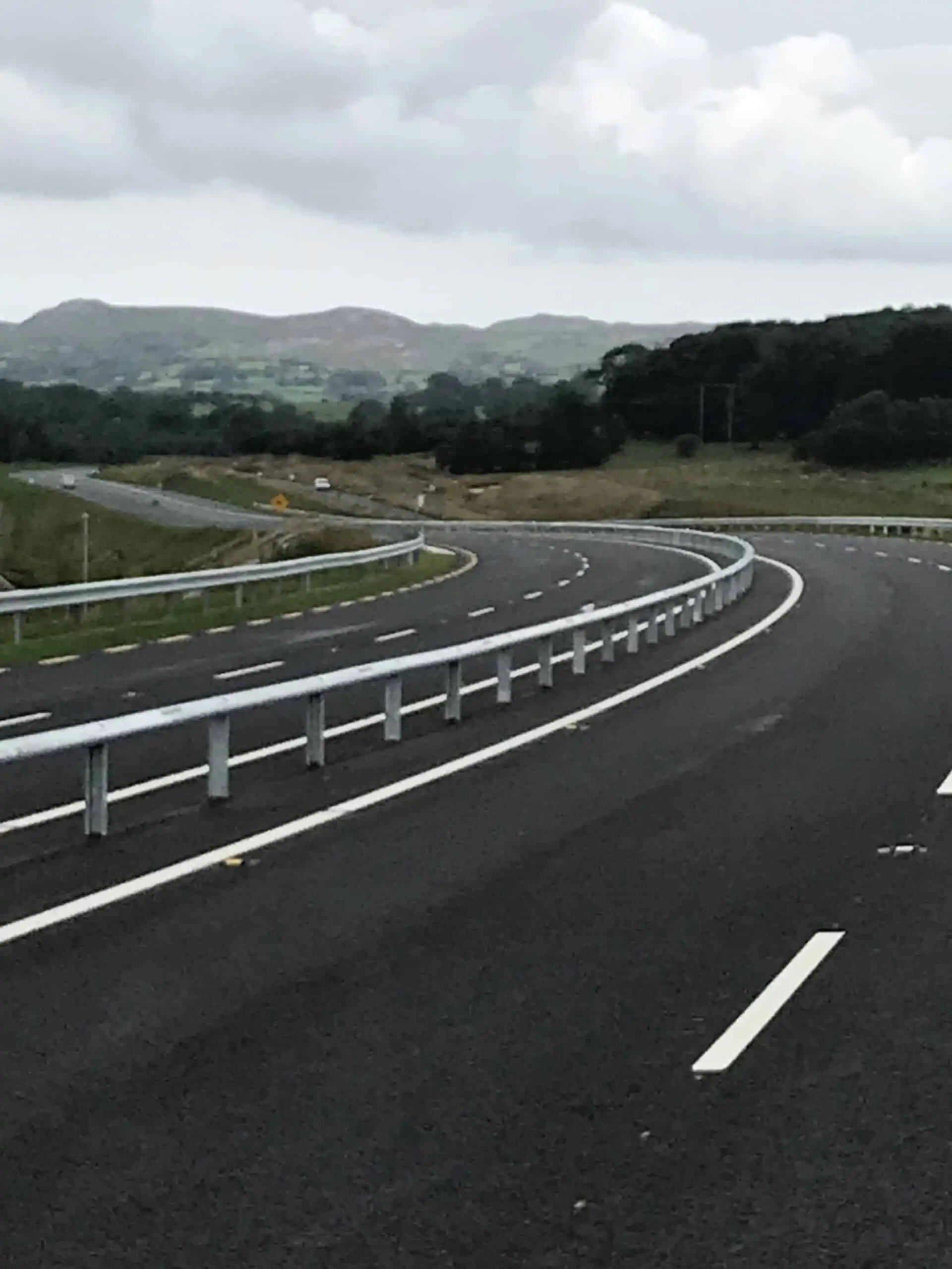
    So more of The Mallow Road cheese graters, is this just a cheap alternative to the proper concrete ones on Motorways ?


  • Registered Users Posts: 208 ✭✭highwaymaniac


    The wire rope has been replaced by a steel barrier - see example picture from N4 Collooney Castlebaldwin.


  • Moderators, Entertainment Moderators, Science, Health & Environment Moderators Posts: 14,344 Mod ✭✭✭✭marno21


    Tarmac down now as far as the eye can see past the Coolyhane Overbridge, which is 3.4km from Coolcower by my estimate. That leaves 2.1km to go to Millstreet Road.

    The next overbridge for visibility is Kilnagurteen which is 4.7km from Coolcower and 800m from Millstreet Road. At this rate they’ll have gone past that bridge within 2 weeks.

    They are absolutely motoring.


  • Moderators, Entertainment Moderators, Science, Health & Environment Moderators Posts: 14,344 Mod ✭✭✭✭marno21


    Notice from the contractors about works at Coolcower:


    From now until June 24th: works continuing offline with minor traffic management required

    From June 27th for 2 week: traffic restricted to one way flow controlled by flag men and traffic lights 24/7 5 days per week

    From July 11th til October: daytime stop go systems in place.

    That 2 week period from June 27th on will be absolute Armageddon at peak times.


  • Advertisement
  • Registered Users Posts: 1,440 ✭✭✭KrisW1001


    The tie-in works on this were always going to cause total mayhem at Macroom, two weeks isn’t so bad. I notice an advance warning sign has been set up on N25 advising people to divert via N20 if possible, but it gets a bit lost in amongst all the other signage for the Dunkettle upgrade.

    But, I wonder is that schedule also a hint that the Eastern section will open in October..?


Advertisement