Advertisement
If you have a new account but are having problems posting or verifying your account, please email us on hello@boards.ie for help. Thanks :)
Hello all! Please ensure that you are posting a new thread or question in the appropriate forum. The Feedback forum is overwhelmed with questions that are having to be moved elsewhere. If you need help to verify your account contact hello@boards.ie
Hi all,
Vanilla are planning an update to the site on April 24th (next Wednesday). It is a major PHP8 update which is expected to boost performance across the site. The site will be down from 7pm and it is expected to take about an hour to complete. We appreciate your patience during the update.
Thanks all.

2021 Atlantic/Pacific Hurricane Season

Options
1356

Comments

  • Registered Users Posts: 8,219 ✭✭✭Gaoth Laidir


    18Z LGEM has it at 109 kts at landfall this time tomorrow.


  • Registered Users Posts: 8,219 ✭✭✭Gaoth Laidir


    The LGEM and Official are both at the upper end of the intensity guidance, just on the cusp of Cat 4 at landfall (24 hours). Others not quite so bullish. It will all come down to nowcasting and ERCs.


  • Registered Users Posts: 8,219 ✭✭✭Gaoth Laidir


    Up a smidgen now to 90 knots (105 mph) in the latest update.


    Hurricane Ida Discussion Number  10
    NWS National Hurricane Center Miami FL       AL092021
    400 PM CDT Sat Aug 28 2021
    
    Ida's satellite presentation has continued to improve this
    afternoon, with the eye becoming more apparent in both infrared and
    visible satellite imagery.  The eye is surrounded by a symmetric
    ring of cold cloud tops and new convection with lightning as seen
    by the GOES-16 GLM sensor has been rotating around the western 
    portion of the eyewall within the past few hours. The upper-level 
    outflow has also become well established over the hurricane and 
    several spiral bands are noted over the northern semicircle.  
    Subjective Dvorak satellite intensity estimates have increased to 
    T5.0 and these support increasing the initial intensity to 90 kt 
    for this advisory.  Both NOAA and Air Force Reserve reconnaissance 
    aircraft are scheduled to be in the hurricane within the next few 
    hours and should provide additional information on Ida's current 
    strength. Earlier aircraft and satellite wind data indicate that the 
    tropical-storm-force wind field has continued to expand over the 
    eastern semicircle and the initial wind radii have been adjusted 
    outward.
    
    The hurricane appears to have begun its anticipated rapid 
    intensification phase.  A favorable upper-level wind pattern, warm 
    waters along the track, and a moist atmosphere are expected to allow 
    for additional rapid strengthening overnight and early Sunday.  This 
    is again supported by the majority of the intensity models, and the 
    NHC wind speed forecast continues to call for rapid strengthening, 
    bringing Ida to Category 4 status within 12 to 18 hours.  An eyewall 
    replacement cycle could occur as Ida nears the northern Gulf coast, 
    so some fluctuations in intensity are possible during that time.  
    After landfall, rapid weakening is expected, and Ida is forecast to 
    become a post-tropical cyclone by day 4, and it is likely to be 
    absorbed along a frontal zone by day 5.
    
    Ida has moved a little to the right of the previous track, but the 
    long-term motion motion is still northwestward or 320/14 kt.  The 
    track forecast philosophy remains unchanged.  Ida is expected to 
    continue on a northwestward heading through late Sunday as it is 
    steered around the southwestern portion of a deep-layer ridge near 
    the southeastern United Stated coast.  After landfall, Ida's forward 
    motion is forecast to slow when it turns northward around the 
    western extent of the aforementioned ridge.  By Tuesday, the cyclone 
    should reach the southern extent of the mid-latitude westerlies, 
    causing it to turn north-northeastward across the Lower Mississippi 
    and Tennessee Valleys.  The track guidance has nudged slightly 
    eastward during the first 12-24 hours, primarily due to the more 
    northeastward initial position, and this has required a slight 
    rightward adjustment in the new official forecast at those times.  
    The remainder of the NHC forecast is largely unchanged from before, 
    and lies near various consensus models and the GFS ensemble mean.
    
    Users are again reminded to not focus on the exact details of the 
    track forecast as storm surge, wind, and rainfall impacts will 
    extend far from the center.  Rainfall impacts will also spread 
    inland across the Lower Mississippi and Tennessee Valleys through 
    early next week after Ida makes landfall.
    
    Key Messages:
    
    1. There is a danger of life-threatening storm surge inundation 
    Sunday along the coasts of Louisiana, Mississippi, and Alabama  
    within the Storm Surge Warning area. Extremely life-threatening 
    inundation of 9 feet or greater above ground level is possible 
    somewhere within the area from Morgan City, Louisiana, to the coast 
    of Mississippi. Overtopping of local levees outside of the Hurricane 
    and Storm Damage Risk Reduction System is possible where local 
    inundation values may be higher. Interests throughout the warning 
    area should follow any advice given by local officials.
    
    2. Ida is expected to be an extremely dangerous major hurricane when
    it reaches the coast of Louisiana. Hurricane-force winds are
    expected Sunday in portions of the Hurricane Warning area along the
    Louisiana coast, including metropolitan New Orleans, with
    potentially catastrophic wind damage possible where the core of Ida
    moves onshore. Actions to protect life and property should be rushed
    to completion in the warning area.
    
    3. Damaging winds, especially in gusts, will spread inland near the
    track of the center of Ida across portions of southeastern Louisiana
    and southwestern Mississippi Sunday night and early Monday. These
    winds will likely lead to widespread tree damage and power outages.
    
    4. Ida is likely to produce heavy rainfall Sunday into Monday across 
    the central Gulf Coast from southeast Louisiana, coastal 
    Mississippi, and far southwestern Alabama, resulting in considerable 
    to life-threatening flash and urban flooding and significant river 
    flooding impacts. As Ida moves inland, significant flooding impacts 
    are possible across portions of the Lower Mississippi, Tennessee, 
    and Ohio Valleys through Wednesday.
    
    FORECAST POSITIONS AND MAX WINDS
    
    INIT  28/2100Z 26.2N  87.0W   90 KT 105 MPH
     12H  29/0600Z 27.5N  88.6W  110 KT 125 MPH
     24H  29/1800Z 29.1N  90.4W  115 KT 130 MPH
     36H  30/0600Z 30.5N  91.3W   65 KT  75 MPH...INLAND
     48H  30/1800Z 32.2N  91.2W   35 KT  40 MPH...INLAND
     60H  31/0600Z 34.0N  90.1W   25 KT  30 MPH...INLAND
     72H  31/1800Z 35.7N  88.1W   20 KT  25 MPH...INLAND
     96H  01/1800Z 38.0N  82.5W   20 KT  25 MPH...POST-TROP/INLAND
    120H  02/1800Z...DISSIPATED


  • Registered Users Posts: 8,219 ✭✭✭Gaoth Laidir


    Windfield based on aircraft recon.


  • Registered Users Posts: 8,219 ✭✭✭Gaoth Laidir


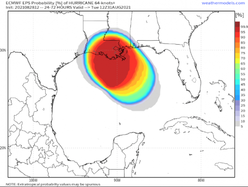
    ECM probability of 96-kt windspeeds.


  • Advertisement
  • Registered Users Posts: 8,219 ✭✭✭Gaoth Laidir


    Latest microwave scan. Still a fairly asymmetrical eye, as evident on conventional satellite imagery too. If it delays any longer then when it does actually form there may not be time for an ERC before landfall.


  • Registered Users Posts: 8,219 ✭✭✭Gaoth Laidir


    Recon has just measured a central pressure of 969 hPa, down 7 hPa since the 10 pm update. Max SFMR surface winds in the northern eyewall 81 knots.


  • Registered Users Posts: 6,235 ✭✭✭Oneiric 3


    Wide risk zone.

    New Moon


  • Registered Users Posts: 23,442 ✭✭✭✭Kermit.de.frog


    Looking healthy right now. The cloud tops firing upward on the western side of the eyewall. The trajectory seems less wnw from the earlier forecast cones. I wonder if that is just the normal wobbling motion or a firmer track east of previously forecast which is important for New Orleans.


  • Registered Users Posts: 23,442 ✭✭✭✭Kermit.de.frog


    The eye is now almost enclosed by deeper convective storms but has yet to clear out. Presumably soon. Definitely strengthening right now.

    blob:https://www.tropicaltidbits.com/80c4e6a8-fd93-4e1f-8f39-691b03be20ad


  • Advertisement
  • Registered Users Posts: 23,442 ✭✭✭✭Kermit.de.frog


    Serious intensification now. Sub -70c cloud tops now completely circle the eye. Much better definition and the eye is clearing out. May be Cat 3 at next advisory.


  • Registered Users Posts: 23,442 ✭✭✭✭Kermit.de.frog


    Looks like it could be a Cat 4 already on the satellite images. Very rapid intensification.


  • Registered Users Posts: 7,116 ✭✭✭pad199207


    😳 serious rate


  • Registered Users Posts: 7,116 ✭✭✭pad199207


    Cat 4 now, basically skipped Cat 3


  • Registered Users Posts: 8,219 ✭✭✭Gaoth Laidir


    Latest multiplatform windfield. The max winds are concentrated in the NE eyewall.


  • Registered Users Posts: 7,116 ✭✭✭pad199207


    Looking at the radar it looked that maybe an ERC was about to get underway.


  • Registered Users Posts: 7,116 ✭✭✭pad199207


    Winds up to 140mph. This is going to be pretty severe for Louisiana


  • Registered Users Posts: 8,219 ✭✭✭Gaoth Laidir


    Up a smidgen now to 140 mph in the 09Z update.


  • Registered Users Posts: 8,219 ✭✭✭Gaoth Laidir


    Currently 120 kts, forecasting 125 at landfall.

    Hurricane Ida Discussion Number  12
    NWS National Hurricane Center Miami FL       AL092021
    400 AM CDT Sun Aug 29 2021
    
    Ida has undergone some dramatic inner-core structural changes since 
    the previous advisory. The eye between 25,000-45,000 ft has become 
    circular with a diameter of about 15 nmi now, and at least two 
    eyewall mesocyclones have been noted rotating cyclonically around 
    the eyewall in both radar and high-resolution 1-minute GOES-16 
    satellite imagery. The result has been rapid strengthening of at 
    least 30 kt during the past 6 hours, along with a pressure drop of 
    more than 15 mb during that same time, with a 6-mb decrease having 
    occurred in the 1-hr period between about 0500-0600 UTC based on Air 
    Force Reserve reconnaissance aircraft eye dropsonde data. The 
    aircraft also measured a maximum 700-mb flight-level wind speed of 
    133 kt in the northeastern quadrant, along with a peak SFMR surface 
    wind speed of 116 kt. Furthermore, NWS Doppler radar velocity data 
    from Slidell, Louisiana, has recently been measuring velocities of 
    120-130 kt between 25,000-30,000 ft, which is quite rare, and 
    indicates that Ida is a vertically deep and intense hurricane. Ida 
    was initialized with 115 kt at 0600 UTC, but the 0900 UTC advisory 
    intensity has been increased to 120 kt based on the 133-kt 
    flight-level wind and the improved structure in both radar data and 
    satellite imagery since the 0609 UTC time of that aircraft 
    observation.
    
    The initial motion remains northwestward, or 315/13 kt. There is no 
    significant change to the previous forecast track or synoptic 
    reasoning. The subtropical ridge oriented east-west along 30N-31N 
    across the southeastern U.S. is forecast to remain intact through 
    the forecast period with only minor shifts in the location and 
    strength of the ridge. As a result, Ida should continue to move 
    northwestward toward the southeastern Louisiana coast today, 
    followed by a gradual turn toward the north tonight after landfall. 
    On Monday, the hurricane is expected to  move northeastward across 
    the Tennessee Valley when Ida moves north of the ridge axis. 
    Impacts and hazards will arrive well before the eye of the hurricane 
    makes landfall. Tropical-storm-force winds are likely to begin later 
    this morning. Therefore, all preparations to protect life and 
    property must be rushed to completion. The new track forecast is 
    basically just an update of the previous advisory track.
    
    Ida will remain over waters with high oceanic heat content for 
    another 6 hours or so. Thereafter, the heat content will drop 
    sharply to less than half of the current value of more than 100 
    units. However, some additional strengthening is expected until 
    landfall occurs. After Ida moves inland tonight, rapid weakening is 
    forecast due to a combination of land interaction, entrainment 
    of drier air, and some increase in westerly vertical wind shear.
    
    Users are again reminded to not focus on the exact details of the
    track forecast as storm surge, wind, and rainfall impacts will
    extend far from the center.  Rainfall impacts will also spread
    inland across the Lower Mississippi and Tennessee Valleys through
    early next week.
    
    Key Messages:
    
    1. There is a danger of life-threatening storm surge inundation
    Sunday along the coasts of Louisiana, Mississippi, and Alabama
    within the Storm Surge Warning area. Extremely life-threatening
    inundation of 9 feet or greater above ground level is possible
    somewhere within the area from Morgan City, Louisiana, to the coast
    of Mississippi. Overtopping of local levees outside of the Hurricane
    and Storm Damage Risk Reduction System is possible where local
    inundation values may be higher. Interests throughout the warning
    area should follow any advice given by local officials.
    
    2. Ida is expected to be an extremely dangerous major hurricane when 
    it reaches the coast of southeastern Louisiana. Hurricane-force 
    winds are expected Sunday in portions of the Hurricane Warning area 
    along the Louisiana coast, including metropolitan New Orleans, with 
    potentially catastrophic wind damage possible where the core of Ida 
    moves onshore. Actions to protect life and property should be rushed 
    to completion in the warning area.
    
    3. Damaging winds, especially in gusts, will spread inland near the
    track of the center of Ida across portions of southeastern Louisiana
    and southwestern Mississippi Sunday night and early Monday. These
    winds will likely lead to widespread tree damage and power outages.
    
    4. Ida will produce heavy rainfall today through Monday across the 
    central Gulf Coast from southeastern Louisiana, coastal Mississippi, 
    to far southwestern Alabama resulting in considerable to 
    life-threatening flash and urban flooding and significant riverine 
    flooding impacts. As Ida moves inland, significant flooding impacts 
    are possible across portions of the Lower Mississippi, Tennessee, 
    and Ohio Valleys through Wednesday.
    
    
    FORECAST POSITIONS AND MAX WINDS
    
    INIT  29/0900Z 28.0N  89.1W  120 KT 140 MPH
     12H  29/1800Z 29.1N  90.3W  125 KT 145 MPH...NEAR SERN LOUISIANA
     24H  30/0600Z 30.6N  91.1W   70 KT  80 MPH...INLAND
     36H  30/1800Z 32.2N  91.0W   45 KT  50 MPH...INLAND
     48H  31/0600Z 33.8N  90.0W   30 KT  35 MPH...INLAND
     60H  31/1800Z 35.4N  87.9W   25 KT  30 MPH...INLAND
     72H  01/0600Z 36.7N  85.2W   20 KT  25 MPH...INLAND
     96H  02/0600Z 38.9N  78.9W   20 KT  25 MPH...POST-TROP/INLAND
    120H  03/0600Z...DISSIPATED
    
    $


  • Moderators, Society & Culture Moderators Posts: 1,706 Mod ✭✭✭✭star gazer


    This is a tough moment for Louisiana and while each storm is different a huge amount has been done to improve defences since Katrina. The risk of Covid spreading in the aftermath won't help either.

    STORM SURGE:  The combination of a dangerous storm surge and the
    tide will cause normally dry areas near the coast to be flooded by 
    rising waters moving inland from the shoreline.  The water could 
    reach the following heights above ground somewhere in the indicated 
    areas if the peak surge occurs at the time of high tide...
    Port Fourchon, LA to Mouth of the Mississippi River...12-16 ft
    Morgan City, LA to Port Fourchon, LA ...8-12 ft
    Mouth of the Mississippi River to Bay St. Louis, MS including Lake
    Borgne...8-12 ft
    Burns Point, LA to Morgan City, LA...6-9 ft
    Bay St. Louis, MS to Ocean Springs, MS...6-9 ft
    Lake Pontchartrain...5-8 ft
    Ocean Springs, MS to MS/AL border...4-7 ft
    Intracoastal City, LA to Burns Point, LA including Vermilion
    Bay...4-6 ft
    Lake Maurepas...4-6 ft
    Pecan Island, LA to Intracoastal City, LA...2-4 ft
    MS/AL border to AL/FL border including Mobile Bay...3-5 ft
    Sabine Pass to Pecan Island, LA...1-3 ft
    AL/FL border to Okaloosa/Walton County Line including Pensacola 
    Bay...1-3 ft
    RAINFALL:   Heavy rainfall from Ida will begin to impact the
    southeast Louisiana coast this morning, spreading northeast into the
    Lower Mississippi Valley later today into Monday.  Total rainfall
    accumulations of 10 to 18 inches with isolated maximum amounts of
    24 inches are possible across southeast Louisiana into far southern
    Mississippi through Monday. This is likely to result in
    life-threatening flash and urban flooding and significant riverine
    flooding impacts.
    
    Ida is forecast to turn to the northeast early Monday and track
    across the Middle Tennessee Valley and Ohio Valley through
    Wednesday, producing the following rainfall totals:
    
    Coastal Alabama to the far western Florida panhandle: 5 to 10 inches
    with isolated maximum amounts of 15 inches, today through Tuesday
    morning.
    
    Central Mississippi: 4 to 8 inches with isolated maximum amounts of
    12 inches, tonight through Monday night.
    
    Middle Tennessee Valley to the Ohio Valley: 3 to 6 inches with
    isolated higher amounts, Tuesday into Wednesday.


  • Advertisement
  • Registered Users Posts: 7,116 ✭✭✭pad199207


    145mph now. Unless the beginning of an ERC occurs, 150MPH might be reached.


  • Moderators, Science, Health & Environment Moderators Posts: 11,814 Mod ✭✭✭✭Meteorite58


    From NWS New Orleans. That is some storm surge

    There has been an update to the forecast storm surge values as of 4AM CT: 12-16ft inundation likely from Port Fourchon to the mouth of the MS River, 8-12ft mouth of the MS to Bay St. Louis. There will be life-threatening storm surge all across coastal Mississippi.

    EDIT: cant edit out the giant wave !!


  • Registered Users Posts: 1,570 ✭✭✭Tyrone212


    Is New Orleans getting a direct hit? I'm abroad at the moment poor coverage can't check anything properly. Cheers


  • Registered Users Posts: 7,116 ✭✭✭pad199207


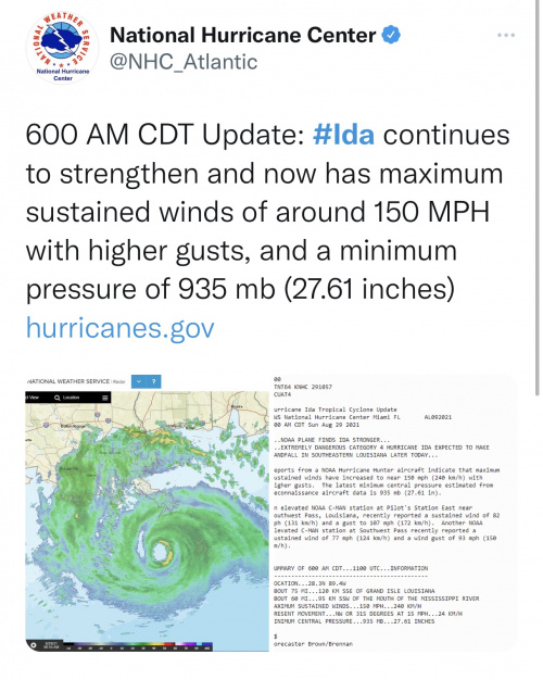
    Looks like latest Recon showing 150MPH.


  • Registered Users Posts: 279 ✭✭almostthere12


    When is this due to make landfall? Thanks


  • Registered Users Posts: 7,116 ✭✭✭pad199207


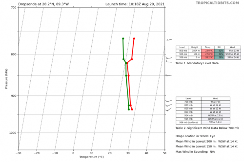
    Latest dropsonde down to 936mb? Strongest storm ever to hit Louisiana possibly.

    Crazy


  • Registered Users Posts: 2,662 ✭✭✭Delta2113


    Hopefully not. You can watch WWLTV LIVE on YouTube.


  • Registered Users Posts: 7,116 ✭✭✭pad199207


    Monster of a storm


  • Registered Users Posts: 8,219 ✭✭✭Gaoth Laidir


    Storm 1 in 1856 got down to 934 hPa as it hit Louisiana.


  • Advertisement
  • Registered Users Posts: 7,116 ✭✭✭pad199207


    Scratch that last. Recon dropsonde just in a minute or two ago has it down to 932mb with Cat 5 winds but this is being checked at the moment.


Advertisement