Advertisement
If you have a new account but are having problems posting or verifying your account, please email us on hello@boards.ie for help. Thanks :)
Hello all! Please ensure that you are posting a new thread or question in the appropriate forum. The Feedback forum is overwhelmed with questions that are having to be moved elsewhere. If you need help to verify your account contact hello@boards.ie
Hi there,
There is an issue with role permissions that is being worked on at the moment.
If you are having trouble with access or permissions on regional forums please post here to get access: https://www.boards.ie/discussion/2058365403/you-do-not-have-permission-for-that#latest

cycle the grand/royal canal

  • 28-01-2014 11:48pm
    #1
    Registered Users, Registered Users 2 Posts: 129 ✭✭


    anybody done the above , whats it like? conditions, accommodation etc


«134567

Comments

  • Registered Users, Registered Users 2 Posts: 2,386 ✭✭✭RebelButtMunch


    pat25c wrote: »
    anybody done the above , whats it like? conditions, accommodation etc

    I did the grand 2 years ago. Camped one night. Conditions varied from good firm gravel to bad grass used by cows or horses. I really enjoyed it though.

    Planning on doing the royal this year.


  • Closed Accounts Posts: 5,793 ✭✭✭Red Kev


    I did both last summer, brief report on the Royal Canal here:

    http://www.boards.ie/vbulletin/showthread.php?p=85607404

    I cycled it in the middle of the hot weather last summer. Believe it or not I traveled by train to Longford today and had a good look at the path I did last summer, some of it is pure muck after all the rain.

    Of the two I preferred the Royal, especially the stretch from Mullingar to the Shannon.


  • Registered Users, Registered Users 2 Posts: 129 ✭✭pat25c


    thanks folks ,that's a great help , i looked it up on line but it was all a bit sh*t & not very helpful


  • Registered Users, Registered Users 2 Posts: 7,769 ✭✭✭Pinch Flat


    Did the Royal and Grand to Tullamore for a day trip a few years back. I used the Inland Waterways for maps: http://www.iwai.ie/framed.map.html


  • Registered Users, Registered Users 2 Posts: 129 ✭✭pat25c


    is the route way marked, to know which side i should be on?


  • Advertisement
  • Registered Users, Registered Users 2 Posts: 110 ✭✭mrbike


    The tow paths are marked on the IWAI maps. There are a few spots where you need to cross over.

    If you can find this book, it's great. It gives you the history of the canal and navigation information. It's great to read as you're doing the trip.

    http://www.amazon.com/Towpath-Tours-Cycling-Irelands-Waterways/dp/1903464757

    It's out of print now, but I managed to find a second hand copy in Chapters bookshop on Parnell Street a while ago. It might be worth a look...


  • Closed Accounts Posts: 5,793 ✭✭✭Red Kev


    pat25c wrote: »
    is the route way marked, to know which side i should be on?


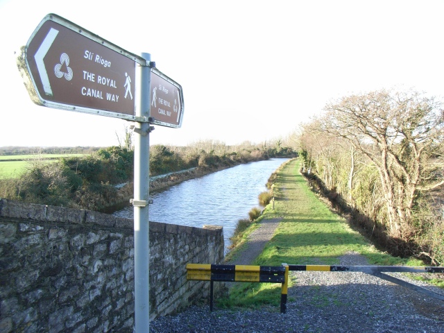
    Both the Grand and Royal are well marked. Always follow the signs, even if the route looks worse at the beginning, as usually only one side is passable.

    Keep an eye out at every bridge for these sign posts.

    1126077_c90b4c3e.jpg


  • Registered Users, Registered Users 2 Posts: 13 WaterwaysIre


    Hi Pat

    We direct people to Irishtrails.ie for the way-marked way information on the Grand and Royal Canal towpath trails. It is the site managed by the National Trails Office http://www.irishtrails.ie/Trail/Grand-Canal-Way/18/ and http://www.irishtrails.ie/Trail/Royal-Canal-Way/28/.People actively use and post reviews about the towpaths, so it is the easiest way to stay on top of any changes or improvements.


    There is also a specific guide to each of the waterways with maps and distance guides enabling you to plan and including village and nearby attractions info. I don't want to promote them specifically here as - its not about us, but you can check out our website/webshop if you wish.


    WI manage both canals on behalf of the taxpayer. We are working to improve the quality of surface on an ongoing basis, currently facilitating work in Fingal, on the Royal Canal, and will be continuing to roll those improvements along the navigations as funding allows.

    I hope thats helpful
    Katrina
    Waterways Ireland


  • Closed Accounts Posts: 2,889 ✭✭✭feck sake lads


    is it permitted to pitch a tent on the walkway overnight you understand.


  • Registered Users, Registered Users 2 Posts: 129 ✭✭pat25c


    thanks waterways ireland that was helpfull


  • Advertisement
  • Registered Users, Registered Users 2 Posts: 110 ✭✭mrbike


    is it permitted to pitch a tent on the walkway overnight you understand.

    According to the canal bye-laws it is... (as long as you stay less than a week).

    http://www.irishstatutebook.ie/1988/en/si/0247.html#zzsi247y1988a30

    Mind you, I was under the impression that cycling on the tow paths was illegal under the bye-laws. It's mentioned here : http://www.iwai.ie/1faq.php3?id=14

    I can't find any reference to bikes being banned in any of the Canals Act bye-laws. That said, I've met plenty of Waterways Ireland employees when I've been cycling on the towpaths, and they never said a word.


  • Closed Accounts Posts: 2,889 ✭✭✭feck sake lads


    last year i cycled from my town drogheda to mullingar camped overnight,i had a look at the canal towpath and to be honest i would not like to cycle on it to feckin rough.


  • Registered Users, Registered Users 2 Posts: 13 WaterwaysIre


    Hi there

    You have a point - the towpaths were designed for house drawn barges, so the surface is not always suitable for cycling, however there actually has been a lot of investment in cycle trails in Mullingar! so I am surprised at your comment there!
    As i said previously, we are rolling out a programme of upgrading the towpaths in conjunction with the local authorities, but we are not there yet!

    RE CAMPING

    I don't tend to camp on the canal itself, some canal towpaths are also roadways, some are farm access, and nearer the towns and villages were you would probably like to stay the towpaths are active walking loops/routes for local people, so they can be quite 'busy' for camping.
    I have asked people if I can camp in their garden or their field, or where there are camp sites not that far off the main line i have stayed in those every couple of nights to 'refresh'.
    Hope thats helpful.

    Katrina
    Waterways Ireland


  • Closed Accounts Posts: 2,889 ✭✭✭feck sake lads


    Thanks Katrina great to hear theres ongoing work, the canal towpaths are a dream for cyclists(no traffic heaven).theres rumers this past 5 years here in drogheda that the drogheda canal will be developed all the way to navan ,oh if this was only the case but not in my lifetime ,i walked it many a time drogheda to slane its only beautifull,and loads of wild camping spots :cool:.


  • Registered Users, Registered Users 2 Posts: 41 HappyNoel


    Have been cycling them over the past few years, did the Grand Canal first (2011), the Royal in 2012 and the Barrow and Grand Canal last summer. Enjoyed them all, some parts are very rough so you'd need a Hybrid at least to be comfortable (mine had front suspension which came in handy at times).

    Hope to do it again this summer, would be a bit slow about doing them outside of summertime, some parts can be mucky. Enjoyed all three but I'd say the best was last summer, did the Barrow from St. Mullins up to where it met the Grand, kept on going West until I met the Shannon. 2 1/2 days solid off road cycling.

    I've met a few Waterways Ireland people on the towpaths, everyone I met was very friendly and accommodating and nobody minded that I was cycling (if anything, they encouraged me). More people using the waterways = more support for WI, I guess.

    Google maps can be useful, some stretches of the towpath are minor roads and have been passed over by the street view car. Just follow the signposts and stick to the official trail.

    Attached are a few pictures from the Grand Canal, you can get an idea of the terrain surface in different spots.


  • Closed Accounts Posts: 2,889 ✭✭✭feck sake lads


    HappyNoel wrote: »
    Have been cycling them over the past few years, did the Grand Canal first (2011), the Royal in 2012 and the Barrow and Grand Canal last summer. Enjoyed them all, some parts are very rough so you'd need a Hybrid at least to be comfortable (mine had front suspension which came in handy at times).

    Hope to do it again this summer, would be a bit slow about doing them outside of summertime, some parts can be mucky. Enjoyed all three but I'd say the best was last summer, did the Barrow from St. Mullins up to where it met the Grand, kept on going West until I met the Shannon. 2 1/2 days solid off road cycling.

    I've met a few Waterways Ireland people on the towpaths, everyone I met was very friendly and accommodating and nobody minded that I was cycling (if anything, they encouraged me). More people using the waterways = more support for WI, I guess.

    Google maps can be useful, some stretches of the towpath are minor roads and have been passed over by the street view car. Just follow the signposts and stick to the official trail.

    Attached are a few pictures from the Grand Canal, you can get an idea of the terrain surface in different spots.
    where is the last picture. i could imagne on a lovely summers day it would be fantastic.


  • Registered Users, Registered Users 2 Posts: 41 HappyNoel


    Last picture was somewhere west of Tullamore, can't remember exactly!

    Did Dublin to Tullamore in one day, although was pretty wrecked when I got there. Had considered camping but by the time I got to Tullamore I was so jacked I went for a B&B instead.


  • Registered Users, Registered Users 2 Posts: 3,095 ✭✭✭ANXIOUS


    I did the royal canal as far as fureys pub and then jumped on the old Galway road to athlone. I had extremely bad luck approximately 8 punctures. The section from
    Castke knock train station through deep sinking was tough not very enjoyable.


  • Closed Accounts Posts: 2,889 ✭✭✭feck sake lads


    its a major pity these canals are a not more cycle friendly it would make for a great cycle tour traffic free heaven.


  • Registered Users, Registered Users 2 Posts: 129 ✭✭pat25c


    its a major pity these canals are a not more cycle friendly it would make for a great cycle tour traffic free heaven.

    i cant imagine that it would cost that much to resurface the tow paths , some kind of packed sand like this off the top of my head
    http://www.mayoman.me/wp-content/uploads/2012/06/greenway99.jpg

    i know i'am probably over simplifying this


  • Advertisement
  • Registered Users, Registered Users 2 Posts: 7,769 ✭✭✭Pinch Flat


    ANXIOUS wrote: »
    The section from
    Castke knock train station through deep sinking was tough not very enjoyable.

    They're in the process of improving this at the moment. New path being laid from Castleknock towards Coolmine bridge. There was talk of a boardwalk to provide a separate path around the Deep Sink. Haven't been down that way in a while, but interested to see how it turns out.


  • Registered Users, Registered Users 2 Posts: 129 ✭✭pat25c


    HappyNoel wrote: »
    Have been cycling them over the past few years, did the Grand Canal first (2011), the Royal in 2012 and the Barrow and Grand Canal last summer. Enjoyed them all, some parts are very rough so you'd need a Hybrid at least to be comfortable (mine had front suspension which came in handy at times).

    Hope to do it again this summer, would be a bit slow about doing them outside of summertime, some parts can be mucky. Enjoyed all three but I'd say the best was last summer, did the Barrow from St. Mullins up to where it met the Grand, kept on going West until I met the Shannon. 2 1/2 days solid off road cycling.

    I've met a few Waterways Ireland people on the towpaths, everyone I met was very friendly and accommodating and nobody minded that I was cycling (if anything, they encouraged me). More people using the waterways = more support for WI, I guess.

    Google maps can be useful, some stretches of the towpath are minor roads and have been passed over by the street view car. Just follow the signposts and stick to the official trail.

    Attached are a few pictures from the Grand Canal, you can get an idea of the terrain surface in different spots.

    great photos , cant believe it's raining in one of them, that's so unlike ireland in the summer


  • Registered Users, Registered Users 2 Posts: 6,737 ✭✭✭Tombo2001


    Possibly not relevant to this thread, but for about two years I was using the Royal Canal for commuting in Dublin.

    Last July there some heavy rains and part of the path at the back of Croke Park subsided into the canal.

    The path was shut off then, and has been shut since, which is a bit disappointing.

    I find the Canal to be a fantastic commuter route, but under used.....it makes sense to put proper cycle paths on it from Castleknock into the IFSC. Would be much faster than the train, and largely off road.


  • Registered Users, Registered Users 2 Posts: 13 WaterwaysIre


    The paths the local authorities or WI put in have to be accessible for as wide a range of users as possible. So yes suitable for cyclists, but also need to be suitable for wheelchair users, buggies, walkers, fishermen etc.

    There are improvements coming: the Castleknowck to Coolmine one is a great example.


  • Registered Users, Registered Users 2 Posts: 13 WaterwaysIre


    Hi Tombo2001

    The towpath in that area is a great way of avoiding the commuter traffic. I have asked the engineer for an update on the repair programme for that section and will come back to you.

    WI


  • Registered Users, Registered Users 2 Posts: 129 ✭✭pat25c


    @waterwaysire, are there any plans to improve the tow paths as far as the shannon? i think it would be a great resourse


  • Registered Users, Registered Users 2 Posts: 13 WaterwaysIre


    Hi Tombo2001

    the engineer has come back to me to say its in the schedule for this session, he will be going out to tender for the work shortly.

    WI


  • Registered Users, Registered Users 2 Posts: 13 WaterwaysIre


    Hi Pat2sc

    Yes there is. We are currently facilitating work in Castleknock to Coolmine and working with the councils in different counties to put the upgraded paths in place. The new strategy by Dept of Tourism on long distance paths is helping focus people's mind's on it, so we are getting the support we needing the local authorities. The paths we put in need to be accessible though, particularly near villages and towns (local people use them for looped walks) so it requires more investment in a better quality surface.
    As funds allow, we will going all the way to the Shannon.

    WI


  • Closed Accounts Posts: 7,410 ✭✭✭bbam


    Hi there

    You have a point - the towpaths were designed for house drawn barges, so the surface is not always suitable for cycling, however there actually has been a lot of investment in cycle trails in Mullingar! so I am surprised at your comment there!
    As i said previously, we are rolling out a programme of upgrading the towpaths in conjunction with the local authorities, but we are not there yet!

    RE CAMPING

    I don't tend to camp on the canal itself, some canal towpaths are also roadways, some are farm access, and nearer the towns and villages were you would probably like to stay the towpaths are active walking loops/routes for local people, so they can be quite 'busy' for camping.
    I have asked people if I can camp in their garden or their field, or where there are camp sites not that far off the main line i have stayed in those every couple of nights to 'refresh'.
    Hope thats helpful.

    Katrina
    Waterways Ireland

    Hi Katrina..
    Has much of the towpath been upgraded at this stage?? And is is mapped anywhere??
    Regards..


  • Advertisement
  • Registered Users, Registered Users 2 Posts: 129 ✭✭pat25c


    does anybody know can you bring a bike on a bus eireann bus , i've looked it up , but can only find scant information on it , like that you will pay a charge , but not how much & that it's at the drivers discretion whether to allow it on board at all . in case your wondering why it's relevant here , i'am planing on cycling the royal canal from longford to dublin & back down on the grand canal , but i'am wondering how to get from galway to longford & back to galway from banagher


  • Registered Users, Registered Users 2 Posts: 22 Paherne


  • Registered Users, Registered Users 2 Posts: 13 WaterwaysIre


    bbam wrote: »
    Hi Katrina..
    Has much of the towpath been upgraded at this stage?? And is is mapped anywhere??
    Regards..

    Hi Bbam

    Towpath upgrades are happening in stages in different counties so there is no map of them yet.

    The maps that we do have are in the Royal Canal and Grand Canal Guides that we publish - remember they are for boats to use, so may lack in detail for cyclists. If you call into any of our offices you could have a look at one to see if it is what you wanted, or they are available through the online shop or Easons. We are working on Activity Maps with OSI but again this is a long term project.

    Katrina
    Waterways Ireland


  • Registered Users, Registered Users 2 Posts: 114 ✭✭01Surveyor


    Last Summer I cycled from Grand Canal Dock to just short of Shannon Harbour. The intention was to cycle to Tullamore in one day and then return to Dublin. Stupidly I went to Ferbane which was way too much. IMO The Grand compares unfavourably with the Royal and much of it is featureless and the tow paths, while easily passable, are mixed in quality and the grass tow paths get quite tiring. There are fewer gates and fences obstructing the Gran Canal towpaths.

    I got a bus from Ferbane to Athlone with my bike no problem.

    The previous year I cycled from Spencer Dock to Richmond Harbour on the Royal. I cycled to just beyond Ballynacargy on day one and from there on to Richmond Harbour and back on day two. Again too much cycling but the Royal was beautiful. However there are quite a few gates and fences which have to be climbed which can be annoying. Be careful on the towpath at the deep sinking after the 12th lock it is rough and very high above the canal, not a good place for a fall.

    Make sure you have well padded gloves and a bike with front shocks as it is very hard on the hands and wrists. Bar ends are vital as you will want to vary your position. Brakes and mechs can get clogged with grass.

    I cant recommend cycling on the canals enough......do it you wont regret it!

    PS A good 'tester' route is to cycle from the Grand Canal Dock via the Grand to Hazelhatch and from there by Road to Maynooth and back to Spencer Dock via the Royal....a really lovely loop


  • Registered Users, Registered Users 2 Posts: 13 WaterwaysIre


    Hi 01Surveyor

    great suggestion for a tester route! How long did that take you and did you meet much traffic on the Hazelhatch- Maynooth road?

    Katrina
    Waterways Ireland


  • Registered Users, Registered Users 2 Posts: 2,386 ✭✭✭RebelButtMunch


    I can chip in here as I cycled from Hazelhatch to Maynooth just last Sunday. Traffic was fine. The only part with traffic is Celbridge. The junction into Celbridge is a bit tricky and needs a bit of bravery but otherwise its fine. Also coming into Maynooth, you'll hit the canal before the town center.


  • Advertisement
  • Registered Users, Registered Users 2 Posts: 114 ✭✭01Surveyor


    Hi Katrina,

    I had no problem with traffic on the roads between the canals however I was doing my spins early on a Sunday morning. I have done two versions of the loop one via Maynooth and a shorter one via Leixlip. In both cases you follow the route from Hazelhatch via Celbridge to Mynooth or turn off the Maynooth road to Leixlip. The Leixlip loop takes less than three hours and the Maynooth loop I seem to recall taking between 3 and 3.5 hours.
    I havent done either loop for a while but I understand that there have been improvements to the tow path making the Deep Sinking in particular a lot safer.
    The trip to Adamstown is very boring and un-canal like due to the development of the tow path as a commuter route with lighting and cctv and paved surface but after Adamstown it is lovely particularly around Gollierstown. It seemed to me that the development of the tow path at the deep sinking was going to be more sympathetic to the canal environment.

    The Canals are a hugely under exploited cycling amentity and offer great cycle tourism potential.

    Hope that helps?


  • Registered Users, Registered Users 2 Posts: 41 HappyNoel


    Would it be a good idea to organise a cycle along the Canals to demonstrate their potential as cycling routes?

    Everyone seems to think it would be a good idea to convert the towpaths to cycle routes - maybe there's a need for an organised cycle to drive the point home....


  • Registered Users, Registered Users 2 Posts: 8,138 ✭✭✭buffalo


    Hi Bbam

    Towpath upgrades are happening in stages in different counties so there is no map of them yet.

    The maps that we do have are in the Royal Canal and Grand Canal Guides that we publish - remember they are for boats to use, so may lack in detail for cyclists. If you call into any of our offices you could have a look at one to see if it is what you wanted, or they are available through the online shop or Easons. We are working on Activity Maps with OSI but again this is a long term project.

    Katrina
    Waterways Ireland

    I'm a little late coming to this, but is there a map of current road*works? I got caught out yesterday at Ashtown where it's blocked off, and had to find my own detour - no suggested alternate routes or signs.

    *path?


  • Registered Users, Registered Users 2 Posts: 1,054 ✭✭✭Bloggsie


    Hi 01Surveyor

    great suggestion for a tester route! How long did that take you and did you meet much traffic on the Hazelhatch- Maynooth road?

    Katrina
    Waterways Ireland
    Hi Katerina,

    good afternoon, I am wondering when the towpath is completed, will it be tramac or gravel. I commute by train from Co. Kildare every day & between Castleknock & NRPW it seems to be tarmac. It would make a far safer commute to the city centre on a car/van/bus/lorry free route.

    Thanks

    Bloggsie


  • Registered Users, Registered Users 2 Posts: 114 ✭✭01Surveyor


    I hope its not tarmac which I think would be inappropriate to the woodland environment. The Deep Sinking section has lots of tree roots which make the path uneven and would soon break up any rigid finish unless the roots and trees were removed which would destroy the canal environment. When I last saw the work it looked to me like a flexible matting was being used. This evens out the surface but allows grass etc to grow through it and will accommodate roots etc. I hope what I saw wasnt temporary.


  • Advertisement
  • Registered Users, Registered Users 2 Posts: 2,386 ✭✭✭RebelButtMunch


    01Surveyor wrote: »
    I hope its not tarmac which I think would be inappropriate to the woodland environment. The Deep Sinking section has lots of tree roots which make the path uneven and would soon break up any rigid finish unless the roots and trees were removed which would destroy the canal environment. When I last saw the work it looked to me like a flexible matting was being used. This evens out the surface but allows grass etc to grow through it and will accommodate roots etc. I hope what I saw wasnt temporary.

    Good point about the tarmac.


  • Registered Users, Registered Users 2 Posts: 114 ✭✭01Surveyor


    HappyNoel wrote: »
    Would it be a good idea to organise a cycle along the Canals to demonstrate their potential as cycling routes?

    Everyone seems to think it would be a good idea to convert the towpaths to cycle routes - maybe there's a need for an organised cycle to drive the point home....

    I think thats a great idea. Perhaps Waterways ireland would promote it, I'd certainly go on it. I suppose there is always the dreaded insurance problem with organising this kind of event though. Maybe its better if a bunch of interested people meet up informaly and head off for a spin. If anyone is thinking of doing so why not post here and we could meet up somewhere.


  • Registered Users, Subscribers, Registered Users 2 Posts: 2,173 ✭✭✭wanderer 22


    Planning on cycling Dublin to Shannon harbour next week. Anyone have any idea what the conditions are like? Hopefully it's not too muddy, though I guess I could always go onto the road for any particularly bad spots.


  • Registered Users, Registered Users 2 Posts: 2,386 ✭✭✭RebelButtMunch


    I'd say the going will be fairly soft, so if you have fat tyres, use them. Also the road doesnt really follow the canal for a lot of stretches so you may find your self taking detours. I'd just stick to the canal.


  • Registered Users, Registered Users 2 Posts: 336 ✭✭franer1970


    Series of photos taken along the Royal Canal from Dublin to the Shannon, approximately one every kilometre.
    http://www.geograph.ie/search.php?i=14551044&page=1&displayclass=slide

    Bit out of date now - latest is from 2010.


  • Registered Users, Registered Users 2 Posts: 336 ✭✭franer1970


    franer1970 wrote: »
    Series of photos taken along the Royal Canal from Dublin to the Shannon, approximately one every kilometre.
    http://www.geograph.ie/search.php?i=14551044&page=1&displayclass=slide

    Bit out of date now - latest is from 2010.

    Same thing for the Grand Canal - Dublin to Shannon Harbour. Latest is from 2012.

    http://www.geograph.ie/search.php?i=49037578&page=1&displayclass=slide


  • Registered Users, Registered Users 2 Posts: 114 ✭✭01Surveyor


    I did the Grand-Royal loop via Hazelhatch and Maynooth on Sunday Maybe the following will be helpful to others.

    Towpath from Grand Canal Dock to the 12th lock is paved all the way and there are no hazzards. I stayed on the South Bank all the way though there are options on the North Bank in some areas. Ignore signs for the 12th lock at Adamstown and stay on the towpath. From the 12th lock to Hazelhatch is largely grass and passes through the Gollierstown Quarry area which has to be one of the nicest stretches of the canal. Grand Canal dock to Hazelhatch is 1.5 to 2 hours.

    Hazelhatch to Maynooth by road is 30 minutes. Follow the road from Hazelhatch to Celbridge and then follow the signs for Maynooth. You will come to a roundabout just at the edge of Celbridge and it is 5k from there to either Maynooth or Leixlip. When you come to the Railway bridge and Canal bridge on the approach to Maynooth cross the road and go onto the towpath which leads to Leixlip and is paved for the first 2k or so. After that its grass but very nice and quite smooth. From Leixlip the towpath is again very good. You will come to the Deep Sinking at the 13th lock (I think). The towpath on the North bank is fine and eventually you have to switch to the South Bank at a bridge and from there to the 12th lock it is an earth track high above the canal and very rutted with tree roots. Its a beautiful area and if you are confident it is great fun but be careful it would not be hard to end up in the canal.

    Unfortunately the stretch from the 12th lock to Ashtown is still closed for works. I took the road South (cul de sac) and took an underpass to a rounddabout that got me back on the N3 and straight to the Half Way House where turned North and back on to the canal at Ashtown and onwards to Cross Guns. The trip from Maynooth was an easy 1.5 hours.

    All in all it was a really lovely spin and not at all hard and conditions were perfect thanks to a dry sunny day on Saturday.

    I'll try to post a few photos later.


  • Registered Users, Registered Users 2 Posts: 1,407 ✭✭✭OldBean


    Do you have a Strava/MapMyRide mapping of that? I'd love to give it a go during the week if the weather is half decent.


  • Registered Users, Registered Users 2 Posts: 307 ✭✭useeme


    01Surveyor wrote: »
    I did the Grand-Royal loop via Hazelhatch and Maynooth on Sunday Maybe the following will be helpful to others.

    Towpath from Grand Canal Dock to the 12th lock is paved all the way and there are no hazzards. I stayed on the South Bank all the way though there are options on the North Bank in some areas. Ignore signs for the 12th lock at Adamstown and stay on the towpath. From the 12th lock to Hazelhatch is largely grass and passes through the Gollierstown Quarry area which has to be one of the nicest stretches of the canal. Grand Canal dock to Hazelhatch is 1.5 to 2 hours.

    Hazelhatch to Maynooth by road is 30 minutes. Follow the road from Hazelhatch to Celbridge and then follow the signs for Maynooth. You will come to a roundabout just at the edge of Celbridge and it is 5k from there to either Maynooth or Leixlip. When you come to the Railway bridge and Canal bridge on the approach to Maynooth cross the road and go onto the towpath which leads to Leixlip and is paved for the first 2k or so. After that its grass but very nice and quite smooth. From Leixlip the towpath is again very good. You will come to the Deep Sinking at the 13th lock (I think). The towpath on the North bank is fine and eventually you have to switch to the South Bank at a bridge and from there to the 12th lock it is an earth track high above the canal and very rutted with tree roots. Its a beautiful area and if you are confident it is great fun but be careful it would not be hard to end up in the canal.

    Unfortunately the stretch from the 12th lock to Ashtown is still closed for works. I took the road South (cul de sac) and took an underpass to a rounddabout that got me back on the N3 and straight to the Half Way House where turned North and back on to the canal at Ashtown and onwards to Cross Guns. The trip from Maynooth was an easy 1.5 hours.

    All in all it was a really lovely spin and not at all hard and conditions were perfect thanks to a dry sunny day on Saturday.

    I'll try to post a few photos later.

    I did the exact same trip yesterday, except on the Royal Canal at the 12th lock I pulled over the hoarding and cycled through to Ashtown. However I was stopped by a pleasant security man who told me the canal path was not yet completed and I was trespassing but it will be completed in 3 weeks, he then allowed me through. It took me almost 4 hours but I thoroughly enjoyed it.


  • Registered Users, Registered Users 2 Posts: 114 ✭✭01Surveyor


    Old Bean,
    Sorry I have no strava data, its a very intuitive route, even my basic advice above is not really needed. You'll enjoy the trip and if you get a day or so of dry weather before hand even the earth tracks are fine, the ground seems to dry out very quickly.

    General Motors,
    I'm sorry I missed you on Sunday, I saw several cyclists fort the first time ever so the word is spreading. I met a guy going against me on what looked like a Trek 30 speed complete with drop bars........hard work!! I met two pedestriansd at the 12th lock who had exactly your experience with the security man but I decided not to chance it.

    I met four boats heading West as there was an 'Effin' bridge opening in Ballybough on Sunday morning or perhaps Saturday.

    I usually stop for a coffee and cake at Douglas and Kaldi in Ashtown but it has got a bit expensive so I now go to Supervalu accross the road and sit on the Quay wall.


  • Advertisement
This discussion has been closed.
Advertisement