Advertisement
If you have a new account but are having problems posting or verifying your account, please email us on hello@boards.ie for help. Thanks :)
Hello all! Please ensure that you are posting a new thread or question in the appropriate forum. The Feedback forum is overwhelmed with questions that are having to be moved elsewhere. If you need help to verify your account contact hello@boards.ie
Hi there,
There is an issue with role permissions that is being worked on at the moment.
If you are having trouble with access or permissions on regional forums please post here to get access: https://www.boards.ie/discussion/2058365403/you-do-not-have-permission-for-that#latest

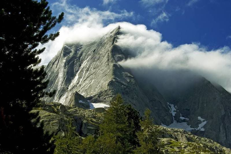
Explanation for these clouds?

  • 10-09-2010 7:52pm
    #1
    Registered Users, Registered Users 2 Posts: 350 ✭✭


    1282600579IIsCPRr.jpg

    I presume the wind is blowing from left to right and is being compressed by the ridge face and then, when the compression is released in the valley, it warms and water vapour is formed? No? Yes?


Comments

  • Banned (with Prison Access) Posts: 2,381 ✭✭✭Doom


    Its Mount Doom, where the nine rings were........:P:P


  • Registered Users, Registered Users 2 Posts: 252 ✭✭alanajane


    Talking of clouds, what sort of clouds were mentioned on this evenings weather forecast of RTE 1, lim something I think? Just curious. (notice all the pregnant ladies gone must be on maternity leave) :)


  • Closed Accounts Posts: 5,150 ✭✭✭Deep Easterly


    1282600579IIsCPRr.jpg

    I presume the wind is blowing from left to right and is being compressed by the ridge face and then, when the compression is released in the valley, it warms and water vapour is formed? No? Yes?

    That is called a 'Banner Cloud'.

    It is formed usually on the side of a hill when air is forced upwards and thus cooled causing condensation.

    Explanation here


  • Registered Users, Registered Users 2 Posts: 5,068 ✭✭✭Iancar29


    Ye i think u hav it there urself.

    I persume it works the same way as hill fog:

    Upslope fog or hill fog forms when winds blow air up a slope (called orographic lift), adiabatically cooling it as it rises, and causing the moisture in it to condense. This often causes freezing fog on mountaintops, where the cloud ceiling would not otherwise be low enough.

    hope that helps :)


  • Registered Users, Registered Users 2 Posts: 5,068 ✭✭✭Iancar29


    alanajane wrote: »
    Talking of clouds, what sort of clouds were mentioned on this evenings weather forecast of RTE 1, lim something I think? Just curious. (notice all the pregnant ladies gone must be on maternity leave) :)

    U sure it was "LIM"?

    I can only think of Lenticular myself....

    http://en.wikipedia.org/wiki/Lenticular_cloud .

    Im sure others wil help if im not right.


  • Advertisement
  • Registered Users, Registered Users 2 Posts: 252 ✭✭alanajane


    nah wasnt that.:o I took notice of the spelling and now I've forgotten, wanted to look it up to see what they were and their effect on weather etc


  • Registered Users, Registered Users 2 Posts: 14,739 ✭✭✭✭M.T. Cranium


    KS, I have seen cloud formations just like that in local mountains, the wind direction is actually more likely to have been right to left or from southeast if this is facing north as I suspect, but winds at peak level could be light westerly. What this shows is probably (as other posters have correctly said) the final stages of some rising moist air on that side of the peak, which for one thing has been shaded while the other side is in full sunlight so any moist layers there would have perhaps evaporated. On a larger scale, this would be upsloping that is common in Alberta and gives them much of their annual rainfall in winds from southeast to northerly directions, otherwise they would be in a dry rainshadow of the Rockies.

    Here's a picture I took with stronger westerly winds blowing through the Crowsnest Pass in southern Alberta (on the BC border) in August 2007, you can see how the cumulus are trying to develop higher and the picture gives some sense of how the air mass dries out once over the crest. On this particular day, skies were generally clear from this point east for about five hundred miles, while partly to mostly overcast to the west for the same distance.

    This is looking north at about mid-day, wind was west 20-30 mph through the pass and probably about 70 mph at cloud height. The mountain is Chief Mountain, and the elevation is about 1200m in the pass to 3000m summit, cloud base about 2800m.


Advertisement