Advertisement
If you have a new account but are having problems posting or verifying your account, please email us on hello@boards.ie for help. Thanks :)
Hello all! Please ensure that you are posting a new thread or question in the appropriate forum. The Feedback forum is overwhelmed with questions that are having to be moved elsewhere. If you need help to verify your account contact hello@boards.ie
Hi there,
There is an issue with role permissions that is being worked on at the moment.
If you are having trouble with access or permissions on regional forums please post here to get access: https://www.boards.ie/discussion/2058365403/you-do-not-have-permission-for-that#latest

Old Pictures or Videos of South Dublin

  • 24-10-2009 10:20pm
    #1
    Registered Users, Registered Users 2 Posts: 47


    Hi, I'm always on the look out for old pictures of south county dublin. I know there is a tread for dublin centre but I thought one for South Dublin would be better. I am looking for old pictures, aerial photos or videos of South Dublin, paricularly the Donnybrook, Dundrum, Blackrock, Clonskeagh area. Thanks.:D


«1

Comments

  • Registered Users, Registered Users 2 Posts: 47 2can


  • Closed Accounts Posts: 9,082 ✭✭✭lostexpectation


  • Registered Users, Registered Users 2 Posts: 47 2can


  • Registered Users, Registered Users 2 Posts: 2,928 ✭✭✭crushproof


    Stillorgan 1964 (Cheers 2can!)
    o_vq0too5g.jpg

    Stillorgan 2009
    stillorgan2009.png w320.png

    You can Bolands at the right hand corner there, the big shed is currently Leisureplex.
    Proof that we really are in love with our cars! :D Suprised that Leisureplex shed has manged to stay up all these years, must be a wreck that this stage!

    I vote for this thread to become a sticky!


  • Registered Users, Registered Users 2 Posts: 720 ✭✭✭1968


    What are we looking at? Would Baumans be on the right and the Stillorgan College of Further Education on the left today?


    stillorgan2.jpg


    from: http://www.histografica.com/view.aspx?p=3lwod70


  • Advertisement
  • Registered Users, Registered Users 2 Posts: 47 2can


    I posted this picture on histographica actually.

    What you are looking at is Stillorgan hill. What is now the Stillorgan Orchard Pub is on the right where you can see the gable with 'J & J Cullen' marked on it. I have heard that this pub was commonly know as 'The Widow Cullens'. To the right is what is now Burn nightclub and what was Blake's restaurant. Further down the hill on the right is now Esmond Motors. All the cottages to the right before 'Cullens' are still there today, everything else is gone.


  • Moderators, Recreation & Hobbies Moderators, Sports Moderators Posts: 15,790 Mod ✭✭✭✭Tabnabs


    2can wrote: »

    To the right is what is now Burn nightclub and what was Blake's restaurant. Further down the hill on the right is now Esmond Motors.

    Eh, these are on the left, no?


  • Registered Users, Registered Users 2 Posts: 47 2can


    sorry, esmond motors is on the left of the picture


  • Registered Users, Registered Users 2 Posts: 47 2can


    I often wondered why the student residences at UCD were called Belgrove. There was no house on that site. I recently figured out that the stream that runs past the residences is flowing through the Belgrove Valley. The was a house (demolished) further down the stream, located at old stillorgan road (approx where the entrance to UCD is, on the N11) called Belgrove.

    The stream flows under the back of the library and into the UCD lake. From there I assume it runs on under the Woodview housing development and into the booterstown marsh.

    Here's a pic of the Belgrove valley, from the 1950's I reckon


  • Registered Users, Registered Users 2 Posts: 4,072 ✭✭✭marcsignal


    This Pathe News clip from January 1941, shows the houses in Rathdown Park in Terenure, that were hit by German bombs.
    It was the first time bombs fell on Dublin during WW2.

    info Here


  • Advertisement
  • Closed Accounts Posts: 4 Wat Tyler


    2can wrote: »
    The stream flows under the back of the library and into the UCD lake. From there I assume it runs on under the Woodview housing development and into the booterstown marsh.

    I believe that's the roebuck stream your referring to?It flows down through elm park golf course on nutley lane before entering the sea behind the petrol station at the merrion gates.It did originally feed into the marsh but at some stage that part of it was cut off.(Apologies for going off topic)


  • Closed Accounts Posts: 1,417 ✭✭✭reprazant


  • Registered Users, Registered Users 2 Posts: 47 2can


    That's interesting to see road before blackrock bypass. Pity it's so fast. Anything else?


  • Banned (with Prison Access) Posts: 94 ✭✭Phenomenally Phrank


    crushproof wrote: »
    Stillorgan 1964 (Cheers 2can!)
    o_vq0too5g.jpg

    That is just insane! other than the shops towards the centre left I wouldn't recognise that picture as Stillorgan at all!:eek::eek:


  • Registered Users, Registered Users 2 Posts: 47 2can


    You can see the old cottages in this article


  • Registered Users, Registered Users 2 Posts: 4,072 ✭✭✭marcsignal


    Terenure Rd East, 1950s, taken from outside the Church, looking towards crossroads.
    The building on the right of the picture, was the tramway ticket offices, and is now Falks Lighting Shop, recently closed down.
    Terenure1950s.jpg

    Terenure 1970. Floods is now Bradys Pub Terenure. The picture was taken from what is now Eddie Rockets Car Park.
    Apartments and shops now stand where The Circle shop used to be.
    The box on the wall at the left hand side of the Circle shop was actually a chewing gum vending machine. 1 piece of gum for 1/2p.
    I was 3 when this photo was taken.
    BradysPubTerenure1970.jpg

    Bank of Ireland Terenure under construction in 1931. Taken from the middle of the crossroads.
    BankofIrelandTerenurebeingbuilt1931-retouched.jpg


  • Registered Users, Registered Users 2 Posts: 47 2can


    Mount Merrion/ Stillorgan/ UCD - 1949


  • Registered Users, Registered Users 2 Posts: 4,072 ✭✭✭marcsignal


    Excellent picture 2can :)

    I uploaded it again here marking some features posters might recognise

    Pink Line = Roebuck Road
    Red Dot = Fosters Avenue
    Yellow Dot = Stillorgan Road
    Blue Dot = St Helens (Radisson Hotel)
    Light Green Dot = Mount Merrion Avenue
    Blue Box = Trees Road district under construction.
    Orange Dot = Mt Anville School


  • Registered Users, Registered Users 2 Posts: 4,072 ✭✭✭marcsignal


    Vaughans Terenure Cross Roads 1910 / 2011
    vaughansmix2.jpg

    Terenure Cross Roads 1910 / 2011
    trnmix.jpg

    Terenure Cross Roads 1910 / 2011
    Bradysmix.jpg

    Terenure Cross Roads 1910 / 2011
    tremix.jpg

    Templeogue Road Looking towards Terenure 1940 / 2011
    Templeogueroadmix.jpg

    Orwell Road Rathgar 1910 / 2011
    OrwellRoad1910-2011.jpg


  • Registered Users, Registered Users 2 Posts: 4,072 ✭✭✭marcsignal


    Did a few of Dublin City

    Rathmines 2011
    rathmines1.jpg

    Rathmines 1910 / 2011
    rathmines1mix.jpg

    Rathmines with Slatterys Pub and Town Hall 2011
    rathmines2.jpg

    Rathmines with Slatterys Pub and Town Hall 1910 / 2011
    rathmines2mix.jpg

    O Connell St 2011
    OConnellst2011.jpg

    O Connell St with Military Parade 1950s / 2011
    OConnellst1942-2011.jpg

    Heuston Station 2011
    heuston.jpg

    Heuston Station 1910 / 2011
    heustonmix.jpg

    Dolphin House Essex St (Off Parliment St) 2011
    dolphinhouse.jpg

    Dolphin House Essex St (Off Parliment St) 1930s / 2011
    dolphinhouse-hotelmix.jpg

    Four Courts 2011
    4courts.jpg

    Four Courts 1930's / 2011
    4courtsmix.jpg


  • Advertisement
  • Registered Users, Registered Users 2 Posts: 4,072 ✭✭✭marcsignal


    During World War 2, on the morning of Jan 2nd 1941 German Bombs fell on Terenure.
    The bombing was believed to be accidental. These were the first bombs to fall on Dublin City during WW2.
    6 Months later, the North Strand was badly hit by German Bombs on May 31st 1941.

    Bomb Damage to houses at Rathdown Park Terenure.
    The top of a 'Beehive' type Air Raid shelter is visible over the garden wall slightly to the right of centre.
    Image0400-1.jpg

    Bomb Damage to houses at Rathdown Park Terenure.
    Image4001-1.jpg

    Police and other Officials survey damage to one of the Rathdown Park Houses.
    3-1.jpg


  • Registered Users, Registered Users 2 Posts: 1,545 ✭✭✭Luckycharm


    Some great pictures there - looks like Terenure has not changed that radically in 100 years


  • Registered Users, Registered Users 2 Posts: 4,072 ✭✭✭marcsignal


    Thanks Luckycharm :) It's hard to get the precise spot for the modern shots with Street View. Ideally I should actually take the modern ones myself from the same spot, so that all the angles, perspective and distance works out, but I've been lucky with some of them.


  • Registered Users, Registered Users 2 Posts: 2,227 ✭✭✭Thinkingaboutit


    http://source.southdublinlibraries.ie/

    Lots here, SDCC area only, but lots to see.


  • Registered Users, Registered Users 2 Posts: 27,349 ✭✭✭✭super_furry


  • Registered Users, Registered Users 2 Posts: 2,820 ✭✭✭donaghs


    crushproof wrote: »
    Stillorgan 1964 (Cheers 2can!)
    o_vq0too5g.jpg

    Stillorgan 2009
    stillorgan2009.png w320.png

    You can Bolands at the right hand corner there, the big shed is currently Leisureplex.
    Proof that we really are in love with our cars! :D Suprised that Leisureplex shed has manged to stay up all these years, must be a wreck that this stage!

    I vote for this thread to become a sticky!

    Great photo! Anyone ever come across photos of the Stillorgan dual carriageway being built, or photos of the old road?


  • Registered Users, Registered Users 2 Posts: 18,854 ✭✭✭✭silverharp


    a reasonably well known one, Sandymount village

    176826.jpg

    A belief in gender identity involves a level of faith as there is nothing tangible to prove its existence which, as something divorced from the physical body, is similar to the idea of a soul. - Colette Colfer


  • Registered Users, Registered Users 2 Posts: 10,758 ✭✭✭✭TeddyTedson


    Imagine we had of kept all our tram lines and railway lines. We'd have one of the best public transport systems in the world.
    Those old trams look amazing. Where are they now? Destroyed?


  • Registered Users, Registered Users 2 Posts: 4,240 ✭✭✭bullpost


    This private collection on flickr has some great old photos of Ireland going back over 50 years.

    Some south Dublin included:

    http://www.flickr.com/photos/88051129@N00/


  • Advertisement
  • Registered Users, Registered Users 2 Posts: 4,072 ✭✭✭marcsignal


  • Closed Accounts Posts: 6,296 ✭✭✭RandolphEsq


    Play The Sopranos song until 13 seconds, then press play on the driving video.
    marcsignal wrote: »


  • Registered Users, Registered Users 2 Posts: 3,614 ✭✭✭The Sparrow


    Play The Sopranos song until 13 seconds, then press play on the driving video.

    That actually works surprisingly well.

    I saw a similar video of London a while ago that was taken in the 50s if I remember correctly. In both videos the thing that stood out most was the lack of road marking and flashing lights/ signs that we have every where now. And somehow the traffic still seemed to flow better.


  • Registered Users, Registered Users 2 Posts: 5,297 ✭✭✭Ron DMC


    That's fantastic. Perfect song for it.


  • Registered Users, Registered Users 2 Posts: 5,150 ✭✭✭homer911


    This 1982 video features Dun Laoghaire / Blackrock

    http://vimeo.com/27435412


  • Closed Accounts Posts: 9,273 ✭✭✭Morlar


    Wow, that one really brought back memories.

    I used to get all those buses (having walked from Cushlawn down that bloody road) whenever the bus drivers decided to stop going up via Cushlawn/Donomore/Knockmore.

    I think that clip was filmed from here:

    187165.JPG


  • Advertisement
  • Closed Accounts Posts: 9,273 ✭✭✭Morlar


    Here are a couple more, Monkstown Village circa 1901, 1905 & a few years ago (not my pics)

    MonkstownChurches_LROY696.jpg


    Monkstown1905.jpg


    monkstown_church_lge.jpg


  • Closed Accounts Posts: 9,273 ✭✭✭Morlar


    (Not my pics) Dun Laoghaire, Georges St
    dusdul1701.jpg

    East Pier, I have apostcard of this one at home with a union jack flying high :

    3142311-East_Pier_1910_Dun_Laoghaire.jpg

    1187267594-2888-0.jpg


  • Registered Users, Registered Users 2 Posts: 5,297 ✭✭✭Ron DMC


    Morlar wrote: »
    East Pier, I have apostcard of this one at home with a union jack flying high :
    I'd love if you could scan that if you get a chance.


  • Closed Accounts Posts: 9,273 ✭✭✭Morlar


    Ron DMC wrote: »
    I'd love if you could scan that if you get a chance.

    Yep, will try and dig it out some evening this week.


  • Registered Users, Registered Users 2 Posts: 398 ✭✭Tripp


  • Advertisement
  • Registered Users, Registered Users 2 Posts: 4,072 ✭✭✭marcsignal


    The Big Snow of January 1982 - Walkinstown / Crumlin


  • Banned (with Prison Access) Posts: 94 ✭✭Phenomenally Phrank


    Tripp wrote: »

    ****ing hell, all the old opels, fiestas + lorries!Not to mention flat tops+levi 501s!!:D


  • Closed Accounts Posts: 6,296 ✭✭✭RandolphEsq


    Looking at all these photos, I really wish we still had those trams!


  • Registered Users, Registered Users 2 Posts: 4,072 ✭✭✭marcsignal


    The Cherry Tree Pub building is visible @ 1:43 in both, the snow, and the football vides above.
    They were both filmed by a guy I know.


  • Moderators, Recreation & Hobbies Moderators, Sports Moderators Posts: 15,790 Mod ✭✭✭✭Tabnabs


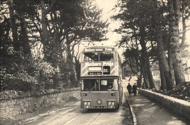
    bb815d7945b03791ea79dca8bcee5d53f9de766.jpg
    In 1980, Brewery Road was still rural, with trees and fields seperating it from Sandyford Industrial Estate, which was much smaller than it is now.

    Just behind the bus you can see the junction with Leopardstown Road - just a simple T junction. The space behind the bus is now taken up by the large roundabout, and Brewery Road is wider, with verges, wider footpaths, and far from rural looking.

    D396 was more often to be found on the 48A, but is seen here on the 86, which was then an all-day service, running half-hourly Mon-Fri and roughly hourly on Saturdays.

    taken from this excellent collection


  • Closed Accounts Posts: 9,273 ✭✭✭Morlar


    Here are the Dun Laoghaire one as promised. It took a while to find them and they are not exactly as I remembered. The union jack is hard to make out but is flying over the yacht club in this one :

    189944.jpg

    Other East Pier one in a postcard taken before Irish Independence.

    189945.jpg


  • Moderators, Recreation & Hobbies Moderators, Sports Moderators Posts: 15,790 Mod ✭✭✭✭Tabnabs


    Morlar wrote: »
    Here are the Dun Laoghaire one as promised. It took a while to find them and they are not exactly as I remembered. The union jack is hard to make out but is flying over the yacht club in this one :

    That's not one of the Clubs, it's the Pavilion.

    untitledyf8.png

    dusdul1695.jpg


  • Closed Accounts Posts: 9,273 ✭✭✭Morlar


    Yep, noticed that after I posted it. Those new ones make it look even more like brighton or one of those south england coastal towns.

    I have another one at home somewhere, it's a photograph gallery of Ireland modern reprint of a famous east pier postcard - I'll see if I can find that one too.


  • Moderators, Recreation & Hobbies Moderators, Sports Moderators Posts: 15,790 Mod ✭✭✭✭Tabnabs


    Actually, I wonder what the Clubs did fly ([pedant]wear[/pedant]) before their current ensigns?


  • Closed Accounts Posts: 9,273 ✭✭✭Morlar


  • Advertisement
Advertisement