Advertisement
If you have a new account but are having problems posting or verifying your account, please email us on hello@boards.ie for help. Thanks :)
Hello all! Please ensure that you are posting a new thread or question in the appropriate forum. The Feedback forum is overwhelmed with questions that are having to be moved elsewhere. If you need help to verify your account contact hello@boards.ie
Hi all,
Vanilla are planning an update to the site on April 24th (next Wednesday). It is a major PHP8 update which is expected to boost performance across the site. The site will be down from 7pm and it is expected to take about an hour to complete. We appreciate your patience during the update.
Thanks all.

WWII structures in Donegal

  • 04-03-2011 5:26pm
    #1
    Registered Users Posts: 610 ✭✭✭muckish


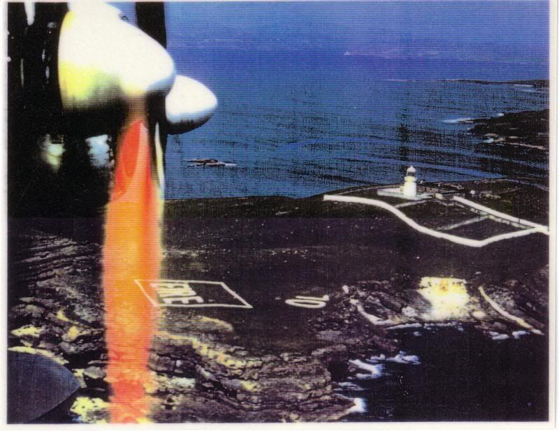
    following on from this post http://www.boards.ie/vbulletin/showthread.php?t=2056009172 in relation to the WWII structures around the Irish coastline. I'm trying to map the locations of the lookout posts and the stone "Eire" signs around the coast of Donegal. I have a few lookout locations such as Shroove head, Malin Head, Fanad Head, Horn head. EIRE signs at shroove head, malin head and sliabh league. Work in progress. If anyone know the locations of more of the above (to quicken the process), I'll be able to plot them on maps.

    much appreciated


«1345

Comments

  • Closed Accounts Posts: 3,548 ✭✭✭Harps


    Lookout post on Arranmore Island, could be wrong about the exact location but I can make out a structure on the ground and its definitely not far off

    http://maps.osi.ie/publicviewer/#V1,564790,918450,7,0


  • Registered Users Posts: 235 ✭✭rushnaldo


    Lookout posts in saint johns point and roshine port Killybegs. Also an eire sign on saint johns point and one on drumanoo head Killybegs. There is also one in Muckross head Kilcar. All in slight disrepair which is a shame I feel.


  • Registered Users Posts: 1,973 ✭✭✭Firblog


    rushnaldo wrote: »
    Lookout posts in roshine port Killybegs.
    Is that the one overlooking Fintra Beach?


  • Registered Users Posts: 235 ✭✭rushnaldo


    No actually its on the other side of the harbour entrance from the lighthouse, there may be two here I havent fished it in a while but definitely one. Access road behind ek marine up in roshine. Forgot bout the one in Fintra.


  • Registered Users Posts: 610 ✭✭✭muckish


    Just found this website. http://www.lookoutpost.com/geographic/
    Should help.


  • Advertisement
  • Registered Users Posts: 692 ✭✭✭Durnish


    According to Karl Cannon's "A Tour of Lettermacaward" there is a white stone Eire sign on a field sloping down to Dooey Strand, Lettermac. I have never been able to make it out, though.
    According to our family legend, far from warning German pilots not to drop their bombs on neutral territory they were in place to warn Atlantic Corridor pilots (Allied airmen) from Lough Erne or B'Kelly that they were now entering neutral Irish airspace.

    I think I remember one outside the Gard station at Burnfoot as well.


  • Registered Users Posts: 3,516 ✭✭✭irish1967


    Another wee link:
    http://www.derelictplaces.co.uk/main/showthread.php?t=15433

    Mainly went googling cause I had no idea what a White stone Eire sign was. Now I do ! :)


  • Registered Users Posts: 610 ✭✭✭muckish


    Harps wrote: »
    Lookout post on Arranmore Island, could be wrong about the exact location but I can make out a structure on the ground and its definitely not far off

    http://maps.osi.ie/publicviewer/#V1,564790,918450,7,0
    Heading out there tomorrow. Will check it out and let you know if you're right! Cheers


  • Registered Users Posts: 610 ✭✭✭muckish


    Durnish wrote: »
    According to Karl Cannon's "A Tour of Lettermacaward" there is a white stone Eire sign on a field sloping down to Dooey Strand, Lettermac. I have never been able to make it out, though.
    According to our family legend, far from warning German pilots not to drop their bombs on neutral territory they were in place to warn Atlantic Corridor pilots (Allied airmen) from Lough Erne or B'Kelly that they were now entering neutral Irish airspace.

    I think I remember one outside the Gard station at Burnfoot as well.

    I can't see the EIRE near Dooey strand on the OSi Aerial Photos. Perhaps the stones were reused after the war.http://maps.osi.ie/publicviewer/#V1,575927,902778,6,0


  • Registered Users Posts: 692 ✭✭✭Durnish


    also one, a concrete lookout from WW2, on Dunmore head above Portnoo.


  • Advertisement
  • Registered Users Posts: 610 ✭✭✭muckish


    I've just noticed from the piece from the BBC "Coast" series about the EIRE markers that the location they have in the video doesn't correspond to the location on the aerial photographs(just behind/above the upper car park at Slieve League) http://maps.osi.ie/publicviewer/#V1,555947,875645,7,0
    Was it moved at some stage recently?

    Also this is EIRE 71 and Shroove Head, Greencastle is EIRE 82, Malin Head 81. I'm presuming they're sequential around the coast. So only 9 to find.


  • Registered Users Posts: 610 ✭✭✭muckish


    EIRE 75 or 76? on Aranmore Island. http://maps.osi.ie/publicviewer/#V1,564839,918510,7,5


  • Registered Users Posts: 1,282 ✭✭✭Carrickman


    Don't know if this counts or not it is a site of a WWII air crash in Kilcar as you can see in some of the photos part of the plane are still their hard many interesting story's about this crash from older family members who lived across the glen at the time. http://www.facebook.com/?ref=logo#!/photo.php?fbid=465321554555&set=a.464984319555.254475.246299599555&theater


  • Registered Users Posts: 3 tunnelvision


    IMG_0700.JPG


  • Registered Users Posts: 3,516 ✭✭✭irish1967


  • Closed Accounts Posts: 1,103 ✭✭✭North_West_Art


    in case it hasn't been mentioned, there is a half buried look-out hut on the beach at Murvagh. It must have been higher up on the dunes at one stage, but ended up on the beach after the dunes were eroded. The concrete hut sticks out of the sand by about a metre.


  • Registered Users Posts: 610 ✭✭✭muckish


    Carrickman wrote: »
    Don't know if this counts or not it is a site of a WWII air crash in Kilcar as you can see in some of the photos part of the plane are still their hard many interesting story's about this crash from older family members who lived across the glen at the time. http://www.facebook.com/?ref=logo#!/photo.php?fbid=465321554555&set=a.464984319555.254475.246299599555&theater
    I'd forgotten about the crash sites. I supposed the most obvious one is on the bluestacks but there are others. There's one at shroove; part of the undercarriage in the car park of the Drunken Duck pub.


  • Registered Users Posts: 235 ✭✭rushnaldo


    A sunderland bomber crashed into crownarad mountain in Killybegs up behind the blue haven killing all onboard. The grass never grew since where it hit. There is a monument erected by locals and older parishioners still remember it happening. Also a plane crash landed on Fintra beach and they survived. The prop of that plane can be seen in the entrance to the clock tower restaurant in Fintra today with the story on their website


  • Registered Users Posts: 692 ✭✭✭Durnish


    looking at Cannon's Lettermacaward book again, I see he says that the Eire sign was in a field to the left of the beach, (to warn German pilots, which sounds a bit unlikely, way beyond their range)which I presume means the present day car park.

    Also to the right on the headland is what must be a WW2 lookout post, immortalised in a poem by Tom Paulin who calls it Melly's Hut or something.

    I also remember a lookout hut on a headland to the east of Portnablagh far pier. Out past the Blow_Hole and climb up to ridge, far as I remember.


  • Registered Users Posts: 82 ✭✭Termonator


    Lookout at crohy head, also supposed to be another Eire in stone there as well but have never seen it.


  • Advertisement
  • Registered Users Posts: 610 ✭✭✭muckish


    Apparently a lot of the EIRE sign were made from whitewashed turf sods laid out on the ground. Probably explains why a lot of them are no longer about. Others seem to be completely overgrown (horn head & St. John's point)


  • Closed Accounts Posts: 3 dinkiedo


    Up in bunglas there are two of these 71 eire .1 is beside car park as shown in os map and the 2nd is further down on the right at the 2 big bends you can make out the 7 and the R clear and the rest if you look close have photo on computer but cant figure out how to load


  • Registered Users Posts: 1,177 ✭✭✭sesswhat


    Another link from a list compiled by Dennis Burke in Tubbercurry:

    Foreign Aircraft Landings in Ireland 1939 - 1946

    Locations are not precise but there is quite a bit of information about each incident.

    My mother remembers the bomber coming down in a field at Edenmore outside Ballybofey so I should be able to pinpoint that one.


  • Registered Users Posts: 610 ✭✭✭muckish


    Great responses from everybody. thanks a million. Plenty there to keep me mapping for a while. Keep them coming though. If anyone can get an XY coordinate from the osi map website for any structure they know of, they'd be greatly appreciated. Cheers all.


  • Registered Users Posts: 610 ✭✭✭muckish


    dinkiedo wrote: »
    Up in bunglas there are two of these 71 eire .1 is beside car park as shown in os map and the 2nd is further down on the right at the 2 big bends you can make out the 7 and the R clear and the rest if you look close have photo on computer but cant figure out how to load
    Just spotted the 2nd one at Bunglas. Feint or what? Cheers


  • Registered Users Posts: 90 ✭✭iioklo


    On the Rosguill peninsula between Horn Head and Fanad there is a WW2 tower near Melmore,
    (where the red cross symbol appears at the center of page)
    http://maps.osi.ie/publicviewer/#V1,612649,943472,7,0


  • Registered Users Posts: 90 ✭✭iioklo


    An EIRE 78 sign is also located just to the north of the Melmore tower on the low lying flat grass mostly overgrown but somebody has been oncovering it you can see from the picture i took last year the 78 is visable

    http://maps.osi.ie/publicviewer/#V1,612681,943730,7,0


  • Registered Users Posts: 610 ✭✭✭muckish


    iioklo wrote: »
    An EIRE 78 sign is also located just to the north of the Melmore tower on the low lying flat grass mostly overgrown but somebody has been oncovering it you can see from the picture i took last year the 78 is visable

    http://maps.osi.ie/publicviewer/#V1,612681,943730,7,0
    That's brilliant. I think it's clearer on the 1995 B&W orthos. http://maps.osi.ie/publicviewer/#V1,612754,943824,7,5


  • Closed Accounts Posts: 3 dinkiedo


    If i get my way the one in bunglas will be clear soon enough :)


  • Advertisement
  • Registered Users Posts: 1,282 ✭✭✭Carrickman


    dinkiedo wrote: »
    If i get my way the one in bunglas will be clear soon enough :)
    Good job, what have you in mind?


Advertisement