Advertisement
If you have a new account but are having problems posting or verifying your account, please email us on hello@boards.ie for help. Thanks :)
Hello all! Please ensure that you are posting a new thread or question in the appropriate forum. The Feedback forum is overwhelmed with questions that are having to be moved elsewhere. If you need help to verify your account contact hello@boards.ie

Hurricane Debbie (1961)

  • 14-08-2010 10:35pm
    #1
    Registered Users Posts: 11,134 ✭✭✭✭


    at196104.gif

    Well it's almost the middle of hurricane season and the models are hinting that there could be some big storms brewing in the not too distant future, so I thought it was a good time to look back at Hurricane Debbie of 1961, an example of how on rare occasions these tropical systems can have a major impact on us.

    Some snippets from the wikipedia page for the storm...
    Debbie is the only known tropical cyclone in history to strike Ireland while still tropical.
    Hurricane Debby made landfall in Dooega on Achill Island during the morning of September 16. Shortly thereafter, it had moved into the Irish mainland over County Mayo. Debby re-emerged into the extreme northeast Atlantic before being declared extratropical.
    When Hurricane Debbie made landfall in Ireland on September 16, it became the only known tropical cyclone to do so while tropical. Hurricane Debbie caused about 11 fatalities in Ireland. It was estimated that Hurricane Debbie and its remnants also injured at least 50 people. A few locations reported winds in excess of 100 mph (161 km/h), including at Balleykelly, Tiree and Snaefell. Strong winds were also reported from Bay of Biscay to location in northern Norway. Its remnants were also responsible for flooding in Ireland, Scotland and Wales.

    Another account of the storm can be read here : http://www.jstor.org/pss/25534822

    From the Met Eireann page for Malin Head :
    The highest measured gust to date is 98 knots, recorded on 16th September 1961 when the remnants of "Hurricane Debbie" swept up along the west coast of Ireland causing widespread damage in this part of the country.

    98 knots is about 181 kph.


Comments

  • Closed Accounts Posts: 4,279 ✭✭✭Su Campu


    Thanks for that, I hadn't heard that fact. I'm a bit puzzled though, as the NCEP Reanalysis shows Debbie losing its tropical characteristics late on the 14th September, being no longer a warm core system, rather a slack baroclinic low as it gets picked up by the deep 500hPa trough in mid Atlantic. By the time it reaches us a day later it's a normal storm system with its centre lying right under a strong southwesterly jet.

    Rrea1961091500.gif

    Rrea1961091512.gif

    Rrea1961091612.gif


    Either I'm reading this all wrong or the reanalysis is wrong. I wonder MT would you shed some light on this as you'll have a lot of professional experience such systems. Do you see tropical characteristics in it??


  • Closed Accounts Posts: 5,150 ✭✭✭Deep Easterly


    Thanks for the Maq! A storm I would have loved to have experienced! I am not sure of whether Debbie was tropical or not but the effects of it certainly were colossal here in the west according to my ancestors.

    Currently uploading the M.S.L.P charts (from the ECMWF re-analysis) between the 13th and 17th of September onto youtube at the moment, should be up in a wee while. A bit shaky as done in a hurry but might give us an idea as to how the storm developed before it smashed into us. Will post up when upload complete.

    Edit. Uploaded now, quality is a bit tripe but might help in M.T's analysis should he hopefully oblige us with one.


    Edit: Link as fecker is coming up as blank! http://www.youtube.com/watch?v=r9rhgofiYz0


    The above shows the east Atlantic M.S.L.P between 00z 13th September 1961 right through to 18z 17th September 1961 in 6 hour increments. We can see the brith of Debbie at around 46sec (15th Sept 18z) forming, as Su notes, within a slack area of low pressure to the SW of Ireland, it then deepens rapidly as it skirts up the west coast at 1.06 mins. (16 Sept 0600) and peaks of the NW coast at 16th Sept 12z).

    What is just as amazing as the rapid development of Debbie is it's rapid disipation once it moves away to our north! :eek:


  • Closed Accounts Posts: 4,279 ✭✭✭Su Campu


    Thanks for that Deep, I can't see the video in your post but I managed to copy the url from it.

    Where did you get the ECMWF reanalysis from? I had no joy getting it from their official site....or else I'm thick! :rolleyes:


  • Closed Accounts Posts: 5,150 ✭✭✭Deep Easterly


    Su Campu wrote: »

    Where did you get the ECMWF reanalysis from? I had no joy getting it from their official site....or else I'm thick! :rolleyes:

    Here you go, thicko!! ;):p

    Edit: Just remembered I had these charts on my hard drive that I posted up before I think at some time.

    High gusts reported during Debbie:

    124188.jpg

    Synoptic chart for 12 noon that day:

    124189.jpg


  • Registered Users Posts: 14,316 ✭✭✭✭M.T. Cranium


    The archived maps show Debbie retaining hurricane intensity until leaving the map grid near the Hebrides.

    http://www.nhc.noaa.gov/tracks/1961atl.gif

    Looking at the surface analysis in this thread, it looks extratropical at map time but back around 1961 the designations would have been more governed by maximum sustained wind speed than structure.

    Whatever it was structurally, it had hurricane force winds and did cat 1-2 type damage in parts of Ireland.

    This reminds me of the un-named tropical storm that we tracked in July through the Irish Sea. In fact that one had more tropical structure, possibly, and a tighter core of strong winds. It would be interesting to see any satellite photos of this storm, from what I remember, satellite imagery was just starting back around that time.


  • Advertisement
  • Registered Users Posts: 6,866 ✭✭✭pauldry


    Here you go, thicko!! ;):p

    Edit: Just remembered I had these charts on my hard drive that I posted up before I think at some time.

    High gusts reported during Debbie:

    124188.jpg

    Synoptic chart for 12 noon that day:

    124189.jpg

    The perfect storm or imperfect maybe. There was also a storm when I was born in 1974 on January 10th. Nothing like debbie but severe none the less. Going to bed to dream of tomorrows sun


  • Closed Accounts Posts: 4,279 ✭✭✭Su Campu


    Thanks for that MT. Maybe that Wikipedia article should be changed to reflect the fact that it wasn't tropical, now that such criteria have changed since that period. But it sure was some storm alright, I wonder will we ever see the like again?


  • Closed Accounts Posts: 5,150 ✭✭✭Deep Easterly


    Met eireann did a feature on Debbie in their september 2001 monthly bulletin. (go to page 16).

    Extract:

    "..Debbie was unusual in developing into a hurricane so
    far east in the Atlantic. It reached category 1 status
    on the Saffir-Simpson scale on the 6th, just off the
    Cape Verde Islands (see chart below) where it caused a
    plane crash and the deaths of 60 people. After
    reaching category 3 status in mid-Atlantic on the
    11th, with mean windspeeds of over 100 knots
    (120m.p.h.), it turned northeastwards towards Ireland
    and lost some of its intensity over the cooler waters
    of the North Atlantic."


    Sustained wind speeds reached violent strom force 11 at many western stations, reaching hurricane force at Malin Head :eek::eek:.

    I wonder is it worth contacting met eireann to get them to shed some light the actual origins of the storm? whether it retained its full tropical status or not as it rammed its power over Ireland?


  • Registered Users Posts: 1,789 ✭✭✭BEASTERLY


    Hi Deep , it's awkward to get the vids imbeded , I managed to figure out last week:D , I hope ya don't mind but i yought I'd post it here for you.

    Deep Easterly's Debbie video:


  • Closed Accounts Posts: 4,279 ✭✭✭Su Campu


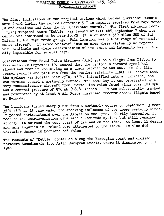
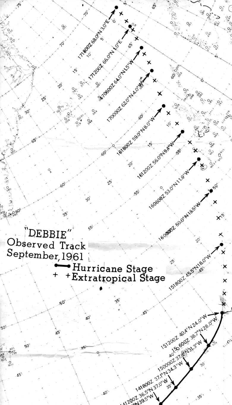
    I've done a bit of trawling and here is some info from the NHC archive. Interesting that they too have it turn extratropical before reaching Ireland, so where did this idea that it was still tropical come from?

    Plenty more info on her here


    prelim1.gif


    track1b.gif


  • Advertisement
  • Registered Users Posts: 14,316 ✭✭✭✭M.T. Cranium


    The difference of opinion about status probably comes from the widely-accessed seasonal map that I posted earlier -- that series maintains the graphics of "hurricane" as the storm passes Ireland, while other storms in other years at high latitudes are ramped down from hurricane to TS to TD to extratropical. Anyway, with such a strong storm, probably the designation hybrid rather than extratropical is appropriate.

    Evidence that it retained any true tropical characteristics would be in terms of detected eye near the centre, tropical dewpoints around the centre, and fronts not completely absorbed into the central circulation. The map seems to reflect that the storm had been extratropical for at least 12 hours at that point. A large area of hurricane force gusts remained in the vicinity of the rapidly occluding cold front. Compare the July 2010 storm where a very confined area of hurricane force gusts occurred near Aberdaron, Wales for about three hours.

    This storm is probably quite similar in dynamics to the October 1987 "hurricane" that hit southern England. However, instead of redeveloping out of a dormant shadow of a former tropical cyclone, this one (Debbie) was a straight-forward extratropical phase of a continuously active and strong Atlantic hurricane. It's natural that it would be remembered as a hurricane given the transitional phase and weather events.

    By the way, wasn't there a similar strength tropical remnant in October 1927?

    I have the printout of all tropical seasons since 1871 in map form. There have been at least four other extratropical storms that either made landfall in Ireland or came very close. I will post maps of these in a moment. They occurred in 1883, 1887, 1950 (remnants of "Dog") and 1957 (remnants of "Carrie.") Please, no cheap jokes. :cool:


  • Registered Users Posts: 14,316 ✭✭✭✭M.T. Cranium


    For the two references above in the 1880s, go to this link on wetterzentrale

    http://www.wetterzentrale.de/topkarten/fsslpeur.html

    and scan maps for Sep 26-28, 1883 as well as 6 Sep 1887. Maps in this series are for 12z. The 1883 case was depicted at 54N 19W (on 28th at 12z) on the NHC maps, so either this wetterzentrale map has incomplete analysis or there are conflicting data. Another case on Aug 28 of 1883 has an obvious map error incorporated near the NHC reported position of another decaying hurricane. Maps before 1890 do not show anything but tracks so there is no idea of intensity.

    Then for the two more recent events, go to this series and set the dates for September 17, 1950 and September 24, 1957.

    http://www.wetterzentrale.de/topkarten/fsreaeur.html

    These maps are set to 00z ... I verified the time switch from the older series to the newer series by comparing maps for the overlapping time period 1948-50 where it's clearly evident from strong lows that the older maps are for 12z on dates shown.

    The 1950 case is very similar to Debbie, actually -- it was the remnants of the D storm, names had just been introduced and they were using morse code so this was remnants of Hurricane Dog, and look how strong it is on the map near Donegal at 00z 17 Sep 50. This storm followed a strong mid-latitude cyclone as you can see by going back (zuruck) a day or two. Would be interesting to see the wind reports from Belmullet and Malin Head in association with this storm.

    The 1957 remnants of Carrie bounced off the south coast thanks to a high over Scotland and then this storm died out over France. I would imagine there was a heavy rainfall in southern counties from this event.


  • Closed Accounts Posts: 5,150 ✭✭✭Deep Easterly


    This storm is probably quite similar in dynamics to the October 1987 "hurricane" that hit southern England. However, instead of redeveloping out of a dormant shadow of a former tropical cyclone, this one (Debbie) was a straight-forward extratropical phase of a continuously active and strong Atlantic hurricane. It's natural that it would be remembered as a hurricane given the transitional phase and weather events.

    A personal thing but I often wonder (well, actually, I don't..;)) about the 'great' october storm that hit the south of the uk in 1987. Was it, as an actual storm, that great? Of course, hitting such a highly populated area it would have gained some momentum but it is nothing that does not occur say in Scotland at least 3 or 4 times every autumn, winter etc. Had the same storm hit Western scotland, for example, would it have gone down in history as much as much as it did? :confused:


  • Registered Users Posts: 14,316 ✭✭✭✭M.T. Cranium


    DE, you've got a valid point there, but the Oct 1987 storm had the additional component of a thunderstorm squall line which would not have developed in the similar quadrant of the storm further north, although it would have been extremely windy anyway. It was the thunderstorm squall line and the wind rush behind it that did all the damage to forests and buildings in the 1987 storm. Probably something similar happened in the Daniel Defoe storm in 1703.

    I wonder where the "great storm" of January 1839 originated, probably over the central Atlantic somewhere, and it could have had subtropical origins, early January is the very tail end of hurricane season.


  • Closed Accounts Posts: 5,150 ✭✭✭Deep Easterly


    I wonder where the "great storm" of January 1839 originated, probably over the central Atlantic somewhere, and it could have had subtropical origins, early January is the very tail end of hurricane season.

    I actually have a book here right beside me about 'the big wind' of 1839!! (I need to get a life I know..:p).

    From page 47:

    "Meteorologically, when the data is untangled, and the good measurments sorted from the bad, it can be desicribed relatively simply. The storm was the result of a deep depression centrerd to the east of the Hebrides (with an estimated central pressure of 918mb at midnight on sunday at 58N 11W-making it one of the deepest lows recorded so close to the British Isles. This did not wander up from the tropics, it is more likely to have formed in these latitudes, and then moved eastwards across the British Isles".

    taken from 'The Big Wind' by Peter Carr. Published by The White Row Press, 1991 edition.

    The book deals more with the folklore and legend of the storm of 1839 than with the science behind it but my guess it would have been just a standard mid Atlantic storm that bombed big time as it neared Ireland.


  • Registered Users Posts: 14,316 ✭✭✭✭M.T. Cranium


    The great windstorm of Jan 5-6, 1839 is confused in Wikipedia's account with a hurricane in September 1839 that hit Bermuda and was later recorded hitting Ireland ... this is clearly not true of the January storm but I wonder if there's any record of a second big windstorm in September of that year?

    Getting back to the 1839 storm, I have some data here from Providence, Rhode Island for that decade (a daily weather journal with all elements recorded). Looking at that, I see the following:

    A very strong high crested over New England on 31 Dec and 1 Jan 1838-39 (about 1040 mbs). This was followed by a weak coastal storm and northeast winds with 2 inches of snow on the morning of the 4th. This could have been the Ireland storm in its formative phases or at least a trailing piece of energy related to a stronger low that might have been tracking northeast around 40-45 W. The flow after this event seemed to pivot around to fast WNW with a deep but precip-free frontal system racing past on the 7th and 8th.

    From my research model I can see that there was a 3-4 day energy cycle at that point in time, and from these obs I would estimate the track of the low was probably from around 50N 30W towards Donegal and western Scotland.

    It must have deepened to about 930 mbs near the M4 buoy location to have produced the reported winds of 80-100 mph. Is there any source of information that could shed light on the possible September 1839 storm? I would like to send in a correction to the Wikipedia entry where they have this confused with the "Great Wind" event.


  • Closed Accounts Posts: 5,150 ✭✭✭Deep Easterly


    I wonder is it worth contacting met eireann to get them to shed some light the actual origins of the storm? whether it retained its full tropical status or not as it rammed its power over Ireland?

    Contacted them and they agree with M.T and Su on the formation of Debbie:

    Patrick,
    “The dynamic nature of tropical storms and mid-latitude cyclones differ. Tropical storms are warm core, mainly closed cell systems, requiring a sea surface temperature (SST) of at least 26 Celsius and high humidity, the latent heat released as warm, humid, air rises and condenses is converted to kinetic energy as wind if the right conditions exist. Mid latitude (30-60 N) cyclones form under the jet stream where warm and cold air masses meet, resulting in the formation and development of low pressure areas at the surface.

    Tropical storms become extratropical as they move Northwards and the SST decreases, at this stage they also come largely under the influence of the wider atmospheric circulation, including the jet stream. The rapid cyclogenisis in the ‘Debbie’ case is a clear mid-latitude extra tropical phenomena. We would not consider ‘Debbie’ to have been tropical storm when reached in Ireland, although it retained many hurricane characteristics”

    Hope this furthers describes what you are looking for.

    Kind Regards

    Annmarie Hickey

    Climate Enquiries
    Phone: 01 8065533
    Fax: 01 8064216
    www.met.ie


Advertisement